Showing posts with label Plate Tectonics and Associated Hazards. Show all posts

Sunday, 29 April 2012

Geography related Books and Films

Teachers may disagree with this but I dont necessarily think that staring at a textbook all night every night is the only way to revise. Of course there is no substitute for hard work but sometimes (especially for development) I think that watching a relevant film can be quite good. Now for those of you who have kept up with your three hours extra reading each week since Septembet (haha!) then you may have watched/readed a few of these but seeing as a few have asked me for suggestions, I thought I would just qucikly write it all up on here! Follow the links for more detailed reviews, explanation of relevance to modules and trailers....
Development and Globalisation:

Darfur - a group of international journalists travel to a village in Darfur in search of evidence to persuade the UN that genocide has occured but are forced to live after the Janjaweed turn up and threaten to kill them. I am sure you are all aware of the Darfur Crisis and it is a case study you caould name-drop into an answer, also could be useful AS population module but be warned it is very graphic and definetly not one for the faint-hearted!

Invictus - after 27 years imprisionment, Mandela becomes South Africa's first elected president and this film follows his bid to unite the country via the rugby world cup, seeing unification as a prerequisite to development.

Goodbye Bafana - follows the unlikely friendship that forms between Mandela and his prision officer and illustrates some of the social and political impacts of colonialism in South Africa and how they continued to hinder development.

Blood Diamond - amid the explosive civil war overtaking 1999 Sierra Leone; it explores many issues including those surrounding the diamond trade, supply of arms to rebels and child soldiers. This includes links to globalisation, colonialism, the 'paradox of plenty' and simply how civil unrest prevents development.

Painted Veil -  set in China, in the 1920's, and explores the impact of a cholera outbreak on a village, including references as to how religious beliefs make containing cholera even more challenging and the impacts of an earthquake. Focuses quite a bit on the importance of a water supply to development - the link to the module is slightly more tenuous than with some of the other films and books but it is still worth a watch!
Cry Freedom - in South Africa and tells the true story of Biko and his friendship with a white liberal newspaper editor. Good film to watch for development as explores impact of apartheid on development and the importance of political stability for development to occur.

Gandhi -  a biopic about the life of Gandhi with particular reference to his prominent role in India's struggle for freedom from colonial rule.

Slumdog Millionaire - provides an insight into the life of children living in the Indian slums the problems associated here. Also illustrates how they are trying to improve education to enable development.

Erin Brockovich - a good film that presents the negative impacts of the natural gas industry and the extent to which large companies are prepared to go to, to cover this up. Not only would this be good for the AS Energy module but also globalisation with reference to the negative impact of TNCs.

The Constant Gardener - a rather sad story about how a drug company exploit the Kenyan population to allow them to test a new drug, despite the fact they know it has harmful side effects. Also explores the idea of corrupt governments and issues faced in LDCs.
The Cove - this film is very thought provoking and presented the issues surrounding the dolphin trade - before watching this I didn't know a lot about the issue, especially the scale of it in Japan, and it left me feeling very shocked that something like this still exists today in such a developed country. Issues of groupings, tied aid and trade are briefly explored also.

Blood River by Tim Butcher - tells the story of Tim Butchers quest to retrace the journey taken by H.M Stanley in the 1870s. from this you get an insight into the history of the Congo and the factors have effected its development - great book for the development and globalisation module as it provides an insight into the impact colonialism has had on Africa. Chasing the Devil: On Foot Through The Killing Fields of Africa is another Tim Butcher book, although this time based in Sierra Leona, that covers many issues intrinsic to low levels of development in Africa and the problems associated with this.

The Boy Who Harnessed The Power Of The Wind by William Kamkwamba and Bryan Mealer - tells the extraordinary true story of a Malawian teenager who overcame many obstacles to provide electricity and clean water for his village by capturing the energy in both the wind and the sun. Good for AS Energy as well as A2 development and illustrates the importance of energy supplies and appropraite technology to development. It also touches on the issues of living in areas of climatic extremes, the role of education and how corrupt governments influence aid distribution.
PeopleQuake: Mass migration, ageing nations and the coming population crash by Fred Pearce - a book about the population bomb and how demographics is driving politics. Explore how we got to this point and where we are currently heading and how it can be solved. Therefore it is a great book for AS Population (covers practically the entire module with some useful case studies and statistics!) and for A2 development and Globalisation. Human geographers will not doubt love this book but any geographer out there, like myself, who get carried away with the science and forget to mention people, this book is worth a read!
Globalization and Its Discontents by Joseph Stiglitz - as chief economist at the World Bank that author has a unique insider's view into the management of globalisation. In this book he speaks out against the IMF and WTO and the role of the West in driving global politics. This makes it a very good book for globalisation!

Plate Tectonics and Associated Hazards:
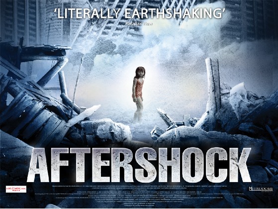
Aftershock - based around the Tangshan 1976 earthquake, which killed 242,000 people and coincided with huge political changes in China. This film cover issues including aid, politics and follows China as it changes over the time period covered. However, it is centred on one question; which 7 year twin will the mother chose to save? Bewarned it is a very said film, Millie was not overexaggerating when she said it was!

Dantes Peak - we watched this one in class, the worksheet we used in lessons is on Millie's blog so this could be a useful thing to watch and complete again as part of your revision. Covers preparation, evacuation and monitoring techniques as well as a few inaccuracies that you should be able to point out!
Eruptions That Shook The World by Clive Oppenheimer - I havent quite finished this book yet but I thought I should mention it as I am finding it quite useful for finding the odd statistic or two! Bascially this book covers everything we need to know about volcanoes and a bit more! Geologists, this is probably a really good book for you to read, but for Geographers it does link all the volcano stuff back to its impacts on people.

Weather, Climate and Associated Hazards:

The Day After Tomorrow - the Larsen B ice shelf collapses, the thermohaline circulation shutdowns, provoking glacial inception in the northern hemisphere, with other appending impacts - a good film to watch and then point out the geographical/scientific mistakes to test how much you have understood about the influence of ocean circulation on global climate and how a freshwater input could affect it!
Encounters at the End of the World - a great documentary with some simply stunning footage and interesting interviews that collectively provide an insight into life in Antarctica and the important research that is taking place
The Age of Stupid - great film to watch for the energy module as it talks about climate change, energy consumption and production via some interesting case studies so also good for the A2 climate module
Gaia by James Lovelock - presents the Gaia hypothesis which is the idea that the Earth functions as a living organism and so self-regulates to adapt to changing conditions. This book puts forward some very interesting ideas, linked very closely to climate change both naturally and anthropogenically forced, making for an interesting read!

 The Revenge of Gaia by James Lovelock - applies the Gaia hypothesis to global climate change - again an intriguing read which presents some interesting ideas and solutions to problems we are likely to face with population expansion and coming global climate change
An Inconvenient Truth by Al Gore - I am guessing most will have heard of this one! It presents the issue of climate change and discusses how it has been caused and the impacts it is likely to have - well worth a read but if you prefer there is also a film version.

Our Choice by Al Gore - this book follows on from An Inconvenient Truth by offering the solutions Al Gore thinks are required to solve the issue of global climate change

Here on Earth by Tim Flannery - This is essentially a "revolutionary dual biography of the planet and our species." It covers the history of the earth from its earliest origins to the world we currently live in. it offers answers to a long list of questions - How did life first emerge? What forces have shaped it? Why did humans come to dominate? And when didiwe start to have an impact? How has this changed use as a species? It is probably wise to have a bit of knowledge of the Gaia hypothesis before reading this as it does mention this a bit. It is a very interesting book and one that leaves you questioning why on earth we did some of the things we have and continue to do - essentially a great book for all Earth Scientists!
Climate Wars: The Fight For Survival As The World Overheats by Gwynne Dyer - "An increase of 2C in average lobal temperature - which is almost inevitable - will hear global politics to boiling point." Bringing together extensive interviews and latest research this book revela the realities of a planet facing scarce food, water and land. Can out technology save us, or is it too late? It is written in an interesting way as takes the science, makes it understandable before focusing on what excatly this means for society now and in the future. Any geographers out there, like myself, who get too carried away with the science of climate change, without consideration of what that means for people, this book is definently worth a read!!!
Storms of My Grandchildren: The truth about the coming climate change and our last chance to save humanity by James Hansen - covers global climate change, with both causes and consequences and the more contemporary role of politics, especially in the USA, in climate research - an interesting read but in places the level of science goes beyond the A-level syllabus.

Well, there are plenty more but this is probably enough to keep you busy for a while! There are also all the relevant documentaries, parts of which we have watched in lessons, like How Earth Made Us, for example, and I think quite a few of them are in the LRC. Unfortunately not many Geography related things are that happy so perhaps don't watch/read them all at the same time! I am still on the hunt for a 'happy' geography film or book! If you have any suggestions for others, or any comments on the above, let me know!


Friday, 2 March 2012

Intrusive Igneous Activity

---> Not all magma makes it to the surface to be extruded, some of it solidifies underground. The igneous rocks formed can contribute to surface geomorphology through uplift, erosion and exposure at the surface.
SILLS = concordant (replaces a bedding plane)
- Rocks get intruded, hotspot of magma underneath, replaces a layer of bedding, therefore is concordant in relation to bedding planes
i.e Whin Sill, Greenland, Palisades
 
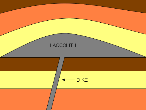
DYKE = discordant (cuts through other bedding planes)
- A vertical intrusion that cuts through bedding planes, therefore discordant in raltion to bedding plane
- Spines of igneous material formed as where dykes cut through bedding rocks surrounding softer rock is easily eroded
i.e Arran dykes

LACCOLITH
- Forms a small upwards, flat-bottomed, dome located within first kilometre of the surface
i.e Montana

BATHOLITH
- slowly cooled igneous rock, greater than 100km2
- produces lots of sandy beaches due to erosion of silica rich granite
- moors very boggy as granite is impermeable to water
- china clay formed by hydrolysis of feldspar within granite
- top of batholith, pressure release cracks, not layers, as weight has been removed
- very popular with climbers and possibilty to exploit geothermal energy = 'Hotrocks' project
i.e Dartmoor to Landsend
VOLCANIC PLUGS
- Quite a lot of castles are built on old igneous intrusive landforms such as volcanic plugs
i.e Edinburgh

GIANTS CAUSEWAY/FINGALS CAVE
- largest basltic lava flows that cooled slow enough to form columnar rock joints, forming hexagnol shapes. Middle parts cooled very slowly comapred to outside
- Gaps that appear between rock columns means it is vulnerable to freeze haw amongst other weathering processes
- Produces very steep-sided coastlines, cliff roughly on a 85 degree angle

Thursday, 1 March 2012

Minor Forms of Extrusive Volcanic Activity


Geysers and Hot Springs :- Even in areas where vulcanism does not generate active volcanies, water heated at depth in the crust by magma chambers can periodically escape as steam and hot water. A geyser is an intermittent turbulent discharge of superheated water ejected and accompanied by a vapour phase. Where hot water on its way upwards mixes with muds near the surface, a bubbling, boiling mud volcano may form. In some places hot springs have become tourist attractions: in Pamukkale (Turkey), dissolved salts from the hot water are lard down in spectacular calcium carbonate deposits, though the area is not volcanically active (read past post on this here).
Geysers
- hot pressurised water, stored in rock cavities underground which increases pressure
- normally find a small mound surrounding a pool of water. The water is very mineral enriched and when it 'splatters' minerals are deposited, forming the mound.
- pools are incredibly colourful due to dissolved minerals
- periodically form a fountain
i.e Old Faithful (Yellowstone National Park), Geysir (Iceland), New Zealand
RISKS - hot water and sulphurous gases
BENEFITS - tourism and geothermal energy exploitation oppurtunities

Hot Springs
- pool of warm geothermally heated water
- less pressurised water, hence no fountains
- water laden with minerals
i.e Japan, BlueLagoon (Iceland - technically a manmade version)
RISKS - very hot water
BENEFITS - tourism and social
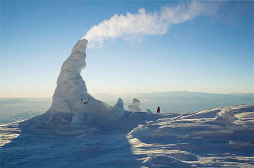
Fumaroles:- Fumaroles are ares where superheated water turns to steam as it condenses on the surface. Personally, I think they look most spectacular when they form in ice, like those on Mount Erebus (this a film review but also contains a description of such fumaroles)

Fumaroles
- superheated water turns to steam, rises and deposits minerals to form chimney-like structures
i.e Stromboli, Erebus
RISKS - hot steam and sulphorous gases
BENEFITS - tourism and mineral extraction

Mudpots
- water geothermally heated, interacts and mixes with mud and surface deposits
i.e Vulcano
RISKS - slightly radioactive and very hot
BENEFITS - tourism


Volcanic Hazards and Management

I am sure everyone is aware of the varying impacts of hazards around the world (Millie has written a very interesting post comparing recovery after the Christchurch, Great Honshu and Haiti earthquakes - it is worth checking out!) and volcanic hazards are no different. Much of this variation is dictated by degree of development but it is important to note that, due to our ability to predict them, no one anywhere in the world should really die as a direct consequence of an eruption. Instead it is the secondary impacts that cause the most problems.

Gas
- All volcanic eruptions are caused by gas escaping from magma with the viscosity of magma determing the ease at which gases escape
                - High viscosity = explosive eruption with pyroclastics
                - Low viscosity = effusive fumaroles with fire fountains and lava
- Active volcanoes produce large volumes of water vapour, carbon dioxide, chlorine, hydrogen sulphide, hydrogen, helium, hydrogen monoxide, hydrogen chloride, amongst other nasty gases. Fortunately they rarely reach lethal levels in populated areas but as carbon dioxide is denser than air it can collect in depressions which allow concentrations to build up to a level capable of suffocation.
- Lake Nyos, 1986, is the only example of gas killing people.
                - August 21st, 1986, limnic eruption occured, triggering sudden release of 1.6 billion tonnes of carbon dioxide. As carbon dioxide is 1.5 times more dense than air, the cloud suffocated some 1,700 people within 20km of the lake and 3,500 livestock. A further 4,000 people fled the area, with many developing health problems a as result of exposure to this hazard.

--> Degassing the lakes is a form of managment as by capturing the gas the risk is minimised. Important to note that 1986 was the first limnic eruption we have known to occur as there is no record of past eruptions. Therefore we were unaware that such a hazard existed. Now, degassing columns have been placed into the lake. The same has been done with Lake Kivu which contains methane. The difference here is that the degassed methane is beign used to run powerstations to provide electricity, aiding development.

Lava Flows
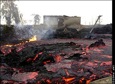
- Only basaltic lavas are 'runny' enough to travel far from their source. Although all lavas slow as they start to cool, basaltic lavas often destroy property but rarely kill people as flows are predictable
- Nyiragongo is the only example where people have died -  in 1977, 70 people were killed. Most recent eruption was 2002 when 300,000 people were forced to flee into neighbouring Rwanda and 15% of Goma was consumed.

--> Management is possible as was seen during the 1973 eruption of Heimaey (Iceland) and Etna. In both cases the lava flows were diverted away from populated areas.

Pyroclastic Flows
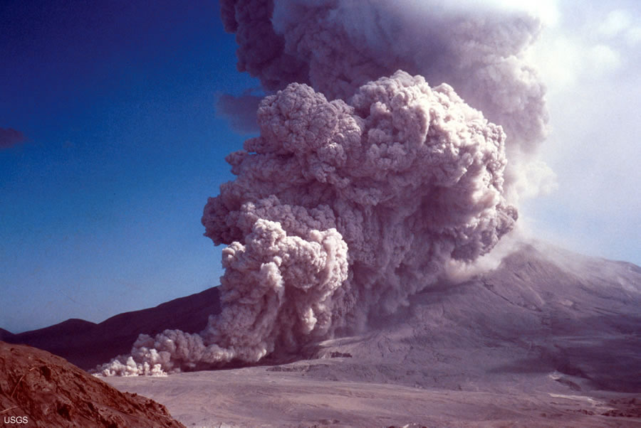
- Mixture of rock, gas, magma blasted out of composite volcanoes.
- Viscous lavas
- Travel at over 300mph with inner temperatures of 500C
- Deadly killers as can affect up to 40km from the vent, travelling in all directions
- Examples = Mount St Helens, Pinatubo and Unzen

--> Only management is effective evacuation, which is reliant on good prediction, as nothing can really stop a pyroclastic flow

Lahars
- Can be set off by the eruption by the melting of a summit glacier - e.g Nevado del Ruiz and Iceland (jokulhlaup)
- Or caused by rain mixing with ash and causing massive continuous flooding - e.g PInatubo, although eruption was last in 1991, a tropical cyclone passed over the area last year provoking a lahar

Landslides
- Landlisdes set off by the eruption can cause destruction
- Mount St Helens eruption was caused by a landslide
- Landslides also can cause tsunamis on islands and coastal volcanoes i.e Stromboli and Krakotoa

Ash
- Ash causes total destruction for hundreds of square kilometres
- Building collapse is most common cause of death due to volcanic hazards
- Destroys land and kills animals. Contaminates water supplies and sets like concrete with rain
- Can cause global cooling and reduce rate of sea level rise - e.g Pinatubo cooled world temperatures by 1C for 5 years
- Economic impacts with disruption to air travel - e.g Iceland E-15 eruption

Good Managment Case Studies
  • Lava flows of basaltic eruptions = Etna and Heimaey
  • Channelling of lahars = Japan
  • Prediction success = Pinatubo, Unzen and Montserrat
  • Prediction failure = Nevado del Ruiz, Mount St Helens
As with any hazard management can be split into several catergories:
- Prediction - now very advance with volcanoes
- Hazard mapping i.e of past eruptions
- Monitoring - many of the worlds volcanoes, especially those near densely populated areas, are monitored
- Evacuation plans and procedures
- Education
- Hard engineering management such as lava flow diversion

Key Points:
- The variation of impacts is controlled by the type of volcanic eruption (therefore in an essay on hazards you could slip in some of your knowledge on silica content etc.)
- Further variation is provoked by degree of development
- If we knew were the volcanoes were it is unlikely we would have settled there! However, the offerded fertile lands to earlier settlers and since then many have grown into densely populated cities. It is unlikely that we will just move the cities away from the hazard (will be interesting to see what decision is made with Christchurch though!) and as population continues to expand more people will come into contact with the risk. Therefore there is an increasing need for management.
REMEMBER:- A hazard does not necessarily put you at risk.....
Hazard = the way in which an object or situation may cause you harm
Risk = the chance that harm will occur
Disasters only occur when people come into close contact with a hazard, hence why the risk will increase as global population expands and more are forced onto marginal lands.
- Nowadays people shouldn't really die directly from volcanic hazards due to our ability to predict them, but people do - why?


Tuesday, 28 February 2012

How are lava type, volcano shape and eruption style linked?

So, I have covered all the boundary types and seeing as I have had a lot of requests on this topic I thought I would move on to the different volcano types and what dictates their formation. Sorry that there has not been much activity on here for a while but there is lots on its way to make up for it!!!

I have to admit that I think the fact that silica, alone, can be used to link all this volcano stuff together is pretty amazing (and surely I can't be the only one!) but how excatly is this the case......

How are lava type, volcano shape and eruption style linked?

Wednesday, 8 February 2012

Convergent Boundaries

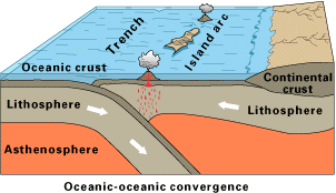
Oceanic vs Oceanic
STAGE 1 - Subduction produces partial melting and the formation of a chain of volcanoes = island arc
STAGE 2 - Build up of intrusive and extrusive igneous material, mixed with sediments, forms larger material
STAGE 3 - The island chain joins up and sediments form an accretionary wedge or prism which builds on to the fore arc area

When the plates collide, one is usually slightly denser than the other, or one is moving slightly faster then the other, so subduction occurs. Consequential subduction and its appending processes are much the same as with oceanic vs continental convergence. When volcanoes erupt islands can form and they usually form characteristically curving lines of new volcanic land (island arcs), with deep trenches. They islands can evolve over millions of years to form major landmasses, like Japan and Indonesia.
Hazards
- Volcanoes = wide cariety of typesm explosive and effusive
- Earthquakes = can be very powerful such as in Indonesia in 2004
- Tidal waves = offshore earthquakes generates waves and the steep islands often suffer inundation, the other cause is collapse of oceanic islands i.e Stromboli

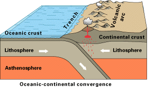
Oceanic vs Continental
STAGE 1 - Weight of continental sediment causes subsidence of the crust
STAGE 2 - Subduction develops and an island arc forms
STAGE 3 + 4 - Compression from plate movement cause the crust to thicken and shorten through folding and thrust faulting. Fold mountain chains are formed i.e the Andes
- Mount St Helens was formed in this way, the Cascades represent the curved line of volcanoes jusr inland on the Western Seaboard
- Thicker the crust the more explosive the volcano is
Oceanic crust is denser than continental crust so when they collide the oceanic crust is subducted. As oceanic crust descends, friction with the overlying crust builds up, generating powerful shallow-to-deep focus earthquakes  that chart the descent of subducting crust. Rocks scraped off the descending plate and folding of continental crust aids fold mountain formation, whereas deep trenches form along the seaward edge of convergent boundaries. Friction generated by subduction processes generates lots of heat that enables partial melting of the crust. Consequently magmas derived from here are less dense than the mantle so it rises up through fissures until it reaches the surface. This magma is also silica enriched, therefore more viscous, hence the explosive volcanic eruptions and presence of intrusions like batholiths.

Hazards
- Very explosive volcanoes i.e Mount St Helens and Popacatepetl

Structure of Subduction Zones

- The shallower the angle of subduction, the greater the Benioff zone, therefore earthquakes can be felt over a larger area. This means it is better/safer to live in an area with a greater angle of subduction.
Characteristics of Subduction Zones
- Trenches - generally 5-8km deep, although Mariana Trench is 11km
- Belt of earthquakes with the shallowest experienced closest to the trench
- Island arcs (archipelago) form, which are usually curved i.e the Aleutian Islands

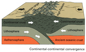
Continental vs Continental
--> This is the process of mountain building as it often reffered to as ab Orogeny, and the moutains as Orogenic Belts
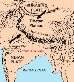
- We are currently in the Himalayan orogeny, where the process of continental collision is still active today
- Over the last 100ma, India has moved northwards. The Himalayan orogeny started well below the equator where an ocean existed to its north called Tethys. The subduction of the oceanic lithosphere thickened the plate to 100km and forced up the fold mountains.
Continental plates have similar densities and their buoyancy means no subduction occurs. Instead, they are associated with orogeny. Volcanics associated with earlier subduction and sediments scraped off the vanishing ocean floor are mixed up and compressed to form young fold mountain chains with deep roots in the lithosphere.
Hazards
- Plate has moved very rapidly (200mm/yr)
- Earthquakes occur often
- Crust is too thick for diapirs of magma to make it to the surface so there are no volcanoes
- Mass movement


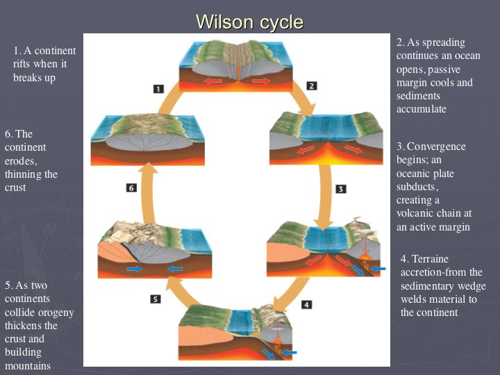
Wilson Cycle = Opening and Closing of Oceans

Rifting controls the opening and closing of oceans. The cycle is known as the Wilson Cycle and it illustrates the balance between new crust being created by volcanic eruptions and destruction of crust at subduction zones, to maintain Earth's fixed size. This helps to explain why there are subduction zones at the edges of most continents.
There are various stages to the Wilson Cycle and each one can be seen in operation across the world today:
  1. The embryonic stage, involves uplift and continental crust extention, resulting in the the formation of rift valleys (e.g. the East African Rift System).
  2. The young stage involves the evolution of rift valleys into spreading regions with thin strips of ocean crust between the rifted continental sections. This forms a narrow, parallel-sided sea, like the Red Sea that is opening between NE Africa and Arabia.
  3. The mature stage is characterised by widening of basin and its continued development into a major ocean flanked by continental shelves and with the continual production of new, hot, oceanic crust along the ridge (e.g. Atlantic Ocean).
  4. Eventually, this expanding system becomes unstable and, away from the ridge, the oldest oceanic lithosphere sinks back into the asthenosphere, forming an oceanic trench subduction system, such as the situation in the western Pacific Ocean. Onset of subduction at the ocean boundary marks the subduction stage (e.g. the Pacific Ocean).
  5. Once subduction overtakes formation of new crust at the constructive boundary, the ocean begins to 'shrink'. Island arc's collide and create young mountain ranges around the periphery of the 'shrinking' ocean. This marks the terminal stage of the cycle (e.g. the Mediterranean).
  6. The end stage occurs when all the oceanic crust between the continental masses has subducted, and the continents converge along a collision zone characterised by an active fold mountain belt, such as the Himalayas. The plate boundary becomes inactive, but the boundary between the two plates remains as a zone of lithospheric weakness. Therefore it has the potential to the site of a new rift and so the cycle continues.

Divergent Boundaries

One of the plate margins is divergent (constructive) and this, in short, is when plates move away from each other, thereby generating tensional forces. As such, they are characterised by shallow-focus earthquakes and volcanism, producing volcanoes which erupt basaltic magma (unevolved) via Icelandic and Hawian style eruptions. 

- Start intra-plate
- Upwelling of magma in a plume, driven by thermo-nuclear reactions in the Gutenburg Discontinuity
- Plume rises and convection starts at the base of the lithosphere
- Convection currents rise and then diverge, creating high temperatures that cause updoming of the crust, along with tensional forces that pull it apart
- In continental crust this can produce rift valley systems such as the East African Rift Valley
- In oceanic crust, new oceanic crust is produced as oceanic ridges are created and seafloor spreading occurs

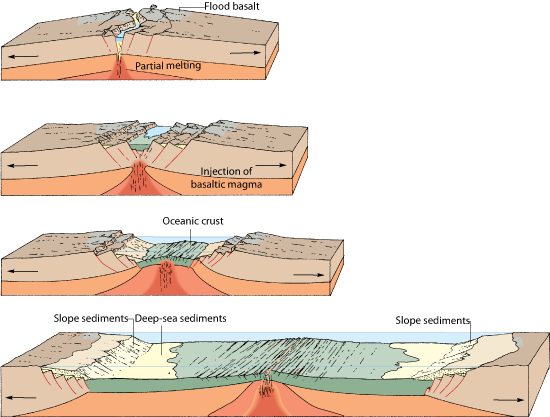
Rifting
- As convection commences the plate is thinned out by a series of extention faults
- As the plate gradually becomes thinner, volcanoes and lakes start to form in the valley
- More volcanoes continue to form until a complete ridge exists, the plate is forced apart and new basaltic oceanic crust begins to form on either side
- As the lakes connect, and the level of the land drops, the ocean floods the valley and forms an elongated sea such as the Red Sea
e.g East African Rift Valley System where eventually a new plate will form (called the Somalia Plate, and the rest of Africa, the Nubia Plate). The sea will eventually flood the valley, connecting to the Red Sea.

e.g Where spreading occurs beneath major landmasses, heating and subsequent updoming leads to fracturing and rifting. As the sides of the rift move apart, central sections drop down to form rift valleys. The Great East African Rift Valley, indicates where the crust has begaun to pull apart, and active volcanoes such as Mount Kilimanjaro and Mount Kenya are surface evidence of igneous activity beneath. At 4000km long, up to 50km wide and 600m in depth, this feature might widen still, allowing sea inundation. To the north, two rifts have widened into the Red Sea and Gulf of Arabia. Here, the rifting has continued, with new sea floor forming between Africa on the south-western side and Arabia on the north-eastern side.
       - Other examples of past rift zones include the steep-sided valley of the River Rhine, athlough there are ancient volcanoes nearby to show how active this region once was, it is no longer subject to rifting.

Oceanic Ridges
= Lines of submarine volcanoes that form a continuous feature throughout the world's oceans
= Centres of spreading where the youngest oceanic rocks are fund closest to the ridge
- They form the longest continuous uplifted feature, with a total combined length of over 60,000km
- Occur on divergent boundaries as a weaker zone is exposed to an increase in surface heat. Hotter crust expandsa new ridge forms and the central part of the ridge may feature a central valley if a section of crust has subsided into the magma below. This split in the crust provides a lower pressure zone where, if more lava erupts, submarine volcanoes can form. If such eruptions persist then volcanoes will develop until they reach the surface, with islands formed in this way i.e Iceland!

Transform Faults
- Spreading does not occur at the same rate along the ridge
- Transform faults offset the ridge, giving it a blocky appearance
- Distance between  the fault varies and they are responsilbe for many undersea earthquakes, but due to a lack of vertical displacement, tsunami's are rarely generated

Hazards
- Frequent low grade seismicity (earthquakes below 5 on Richter Scale)
- Intense and frequent volcanism
- Ultra slow spreading = 10mm/yr i.e Atlantic, Ultra fast spreading = 100mm/yr i.e East Pacific and Galapagos

Tuesday, 7 February 2012

Back to tectonics (FINALLY!!!) - Conservative Margins and Hotspots summary

Hello everyone! I hope the exam went well for you all! We even got mention in the local newspaper - Twin Sails Bridge part of A-level exam - perhaps it would have been interesting to ask students if they would consider visiting Poole before and after studying the bridge for 2 months, then conduct a Mann Whitney U to see if there was a significant difference between number of students inclined to visit the area! Anyway I can now happily say that we will never have to study Poole/Twin Sails Bridge again!!! This means that we can finally get back to good old tectonics.....

Correct me if I am wrong but I think before Christmas I only got as far as outlining the basics of this module, so I have quite a bit to catch up on! I have already lost count of the number of you who have asked very nicely for some case study orientated posts so I will try and find the time over the coming weeks to go over case studies whilst also finding the time to write about Iceland (apologises but I am starting to get a little excited and a condition of me going was that I don't talk about it at home!). For now though I will leave you with a few brief notes on conservative boundaries and hotspots (sorry if the image quality is a bit poor but I gave up trying to find good diagrams online so just photographed my notes) - I am hoping to cover all the volcano stuff this week so I can focus on earthquakes over half term so be warned that a lot of posts may appear over the coming days!

Conservative Margins
These margins are sometimes reffered to as passive or slip margins and occur where two plates meet and the direction of plate motion is either parallel or nearly parallel. No crust is destroyed or created, although these are areas of frequent seismic activity as the build up of friction as the plates pass each other is released by earthquakes. This boundary is not associated with volcanism.
- No subduction or abduction
- Plates try ot move laterally past each other
- Most infamous are the San Andreas Fault in the USA and the North Antolian Fault in Istanbul [both are overdue a huge earthquake!]
- No volcanism
- Generates massive earthquakes

Hotspots
- These are not boundaries, as such, but rather a surface representation of surface plumes
- Plates do not always split above mantle plumes, but as the plate moves over the magma source, it generates a chain of islands
- The oreintation of the island gives an indication of the direction of the plate movement relative to the plume
Hawaii
= Chain of islands, connected to the Emperor Seamount chain (submerged)
= The islands become progressively older to the northwest, indicating the plate is moving in this direction
= This was anticipated before the discovery of continental drift as the islands become shallower in gradient, more advanced vegetation succession and have deeper soils to the northwest.
Other hotspots
- Yellowstone Caldera is probably the niggest and highest risk
- Iceland is unusual being a large plume underneath a divergent boundary
This mantle plume theory is stil hotly debated and poorly understood - it is one of the few remaining mysteries of tectonic theory, which is otherwise now widely accepted.

Divergent and convergent boundary notes are on the way!

Monday, 28 November 2011

Plate Tectonics - the basics...

Seeing as we have just started vulcanicity, I thought it would be a good time for me to re-cap on what we should have learnt so far (we have covered quite a lot of new stuff, especially for non-Geologists such as myself, so this will probably have to be written over a series of posts)......

First up, we need to have a basic understanding of the evidence that exists which supports the theory of plate tectonics. As simply as it can be put, we have older evidence and newer evidence.

Older Evidence:
- Biology - same fossil formations found in different parts of the world
- Geology - rocks of same afe and type and displaying the same formations found across the globe. Similar glacial deposits are found in Antarctica, South America and India, now many thousands of kilometres apart; striations showing the same orientation when the continents are reunited, are found in Brazil and West Africa.
- Climate - fossils of plants that live in tropical conditions found in Antarctica, with it incredibly unlikely that tropical climatic conditions ever existed in Antarctica's current location. PLaces apart across the globe contain coal deposits of similar age that were formed in tropical conditions; they are no longer in tropical climatic belts therefore must have drifted apart since the Carboniferous period.

New Evidence:
- Discovery of the Mid-Atlantic Ridge (1948)
- Paleomagnetism and the reversal of the Earths magnetic field (1950s)
- Seafloor spreading and then carbon dating of the seafloor rocks (1960s)
After passing the Curie Point, iron ions within the lava will
align to magnetic north......
.....This means that as the seafloor has spread, and magnetic reversal has occured in
the past, stripes are visible on the seafloor, preserving a record of the Earth's polarity at the time
of the lava cooling. This has helped to support the idea of seafloor spreading as the youngest
 rock is located nearest to the ridge.

Hopefully, this timeline summarises the key dates and discoveries we need to know about!


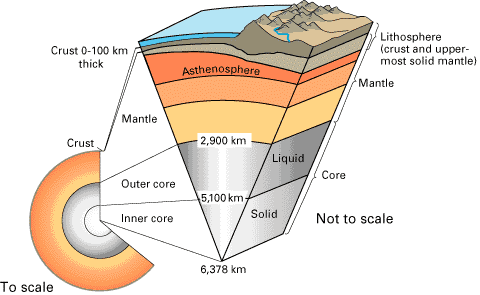
Structure of the Earth:

1. Crust :- it is the upper layer which is solid and is divided into 2 types;
       - Oceanic crust = mainly basaltic in nature and around 6-10km thick. It is more dense and younger than continental curst
       - Continental crust = composed of a wide variety of igneous, metamorphic and sedimentary rock. Can be as much as 70km thick.

2. Moho Discontinuity :- boundary between the crust and the mantle. Average depth of 8km below oceanic crust and 32 km below continental crust. Has density similar tp an olivine-rich rock such as peridotite and so is less dense than the mantle; as such seismic waves accelerate in this region.

3. Mantle :- below the crust. Upper part is solid and is part of the lithosphere. Below this is the asthenosphere which is partly molten and can flow, whilst the rest of the mantle is liquid.
       - Lithosphere = consists of the outer solid part of the Earth, which includse the crust and rigid upper mantle. The lithosphere is about 100km thick, although thickness is age dependent (oldest=thickest). Lithosphere below the crust is brittle enough at some locations to produce earthquakes by faulting, such as within subducted oceanic plate.
      - Asthenosphere = ductile part of the Earth just below the lithosphere, including the lower mantle. It is about 180mk thick. Relatively slow seismic movements compared to the lithosphere.

4. Gutenburg Discontinuity :- boundary between the outer core and the mantle. Where thermal nuclear reactions occur that start convection cells off in the mantle, sending plutons of hot magma upwards. Located at a depth of about 2,800km and marks a sudden increase in density.

5. Outer Core :- liquid iron-nickel alloy, temperatures of over 6000C.

6. Inner Core : - Solid iron-nickel alloy. Even though temperature is higher than the outer core, the pressure produced by overlying weight is strong enough to prevent the liquid state.

How do we know this? Well, studies of earthquake waves, with regards to the velocities and paths of such waves,  depends on what excatly it is they are passing through. P waves can travel through anything but S waves can only pass through solids; so by studying these waves it has been possible for scientists to determine the physical composition of the Earth's interior.

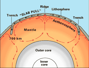
Convection Currents = Driving Force

- Occur in the mantle, very slow convection currents flow in the asthenosphere
- Provide horizontal forces on the plates of the lithosphere, with high temperatures causing updoming and tensional forces pulling the crust apart
- Start in the Gutenburg Discontinuity where thermal nuclear reactions send a pluton upwards

Boundary Types

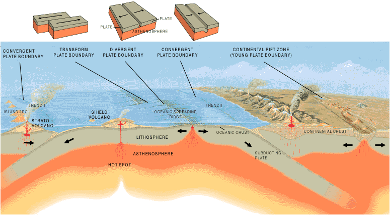
The Earth's lithosphere is split up into 7 major plates, and around 14 minor ones, with some plates composed of both oceanic and continental crust. Between these plates are boundaries/margins, and there are three main types.......
----- I am going to do a seperate post for each boundary type but, in short:-

- Divergent (constructive) = Plates move away from each other, generating tensional forces. Consequently, characterised by shallow-focus earthquakes and volcanoes producing basaltic magma, forming new oceanic crust. Produces oceanic ridges and rift valleys.

- Convergent (destructive) = Plates move towards one another, generating compressional environments, therefore are characterised by deformation, volcanism, mountain building, seismicity and mineral deposits. Three possible types:-
                                                                - Oceanic vs Oceanic
                                                                - Oceanic vs Continental
                                                                - Continental vs Continental
- Conservative = Plates move laterally past each other, or in the same direction at different speeds. Produces a lot of shear stress as lithosphere is neither destroyed or created. No volcanic activity but lots of shallow-focus earthquakes, intensely shattered rock and characterised by production of faults parallel to plate movement.