Sunday, 12 June 2011

Blood River

This is one of the books included on Millie's list of recommended reads and I was slightly apprehensive about reading it as it is classed as travel writing and I don't think I have ever read anything in this genre before as it has never really grabbed my attention ............. BUT I am so glad that I decided to try it as I thoroughly enjoyed it (so much that I have to admit that I read it twice, in succession, before writing this!) and learnt so much about the history of this country!

Butcher, a Daily Telegraph corrsepondent became (ever so slightly!) obsessed with the Congo River after he was posted to Africa and he, soon, developed a desire to follow the route of H.M.Stanley's famous expedition (taken during the 1870s) which, funded by the Daily Telegraphy, altered the course of African history for ever. This book provides a detailed account of Butchers experience as he tried to follow in  the footsteps of Stanley. On his journey, Butcher meets some incredible people who have, equally, incredible stories to tell of the days when the DR of Congo was under Belgium colonial rule, of the wars that have spilled over into the country and the problems faced after independance was granted in 1960. Whilst under colonial rule the Congo had well maintained and frequently used railway networks, riverboat services and around 111,971km of roads. The cities were alive with numerous shops and restaurants whilst industry was also looking good. Since independance was gained war has torn this country to shreds and left behind poverty, disease, civil unrest, disintergrated infrastructure, deteriorated buildings and under 1000km of road.

It is only once you have read the book, I feel that you can fully apprecaited the meaning of the subtitle ' A Journey to Africa's Broken Heart'. Butcher uncovered a country that was not so different to the one Stanley witnessed. Butcher frequently uses phrases like "I was travelling through a country with more past than future, a place where the hands of the clock spin not forwards, but backwards" to describe the fact that this is a nation that is not underdeveloped but underdeveloping. A country where the older generations have had more exposure to the modern world than the younger generations for whom the site of Butcher on a motorbike, the main mode of transport used due to the terrain and scarity of fuel, was the first vehicle they had ever seen in the remote locations many chose to reside. The Congo seems to be a truly broken nation, whose scars run deep into the past and, unfortunately, look likely to be ever present in the  near future.

This is a really really good book and has many links to Geography. It frequently refers back to the Rwandian Genocide and the problems that this caused in the Congo itself. Development is the crucial theme that runs throughout and the impacts that colonialism have had on it. I would definetly recommend that anyone who does Geography or has an interest in, not only Geography but, African history reads this as it is written in such a way that allows it to be remarkably informative and  it grips your attention from beginning to end. The only problem is that, despite the constant references throughout to the forever present dangers that exist in the modern day Congo, I quite fancy visiting some of the places mentioned for myself and witness not only the problems being experienced, but also the efforts of those trying to heal the wounds inflicted by the Congo's messy past - but for now, for safety reasons, I think I might stick to reading about it in books!!!

One thing that both this book and the two films I watched, that were based in India, have made me think about is the impact that colonialism has on sustainable development; something I think I will investigate further before writing a post on it.......

Cry Freedom - a student's film review

Another film review (sorry- I watched these films a while ago and due to revision never got around to writing about them) of a film, that again, could be linked to development. This time though, it is not set in India but in South Africa.

Cry Freedom is a film about the friendship that develops between a black activist, Stephen Biko, and a liberal white newspaper editor  when, after the forceful and violent demolition of a slum in southeast South Africa, Donald Woods (the newspaper editior) goes in search of Biko who was banned, by the South African Government, from talking publicly and leave a stated area. When Woods meets with Biko, he is invited to visit a township where he can witness himself the impoverished conditions people were forced to live in and the impact on the people of the restrictions imposed by the South African Government's apartheid system. Biko later dies, under suspicious circumstances, whilst in police custody. In response, Woods tries to expose the police involvment in Biko's death, and in the process gets himself banned like Biko was, and then goes on, risking his life and that of his family, to bring Biko's message to the world.

I think that this a a really good film and it covers many topics such as discrimination, political corruption and repercussions of violence. The images at the beginning in the slum are horrific and the endless list of names of fellow activists who had died, accompanied by the 'offical' explanations for their deaths, really enforce the scale of this. In conclusion, the film provides a good, accurate historical account of the suffering caused by apartheid and makes it easier to understand why, despite the existance of equal human rights, that seperation in various guises still exists today. I would strongly suggest watching this film as it is a very moving and riveting and, like mentioned previosuly, could easily be linked to develpment.

Gandhi - a student's film review

Another one of my geography films of the week, from a while ago, is also set in India. Gandhi, a film made in 1982, is a film (as the title suggests) that depicts the life of Gandhi.

On the back of the DVD it says that "Gandhi was not a ruler of nations, nor did he have scientific gifts. Yet this small, modest man did what others before him could not. He led an entire country to freedom - he gave his people hope." and that is excatly what he did. He achieved so much for the people of India and, rightly so, is a greatly remembered and celebrated man. There are statues and pictures of him everywhere in India and he also features on their currency and this film tells the story of his life from when he arrived in South Africa in 1893 right up until he was assasinated in Delhi in 1948, with particular focus on India's struggle for freedom from colonial rule from 1915 onwards.

The first part of the film portrays Gandhi's struggle to force the South African Government to end the discrimination against the Asian community. From this struggle, the film provides you with an insight into life in South Africa at this time and this insight enables you to make contrasts to what India was like during a similar period. The majority of the film though is set in India from 1915 onwards, the year in which Gandhi returned to his home country after 20 years away and was driven around the streets of Bombay and deeply hurt and shocked by the poverty he saw.  The film, which I have to point out is 3 hours in length, from then on, focuses on the key events in the sturggle, led by Gandhi, for India's freedom from colonial rule. This includes scenes such as the horrific massacre at Amritsar, 1919,  in an enclosed courtyard, where the British opened fire on 15 000 unarmed men, women and children, killing 400 and severly injuring 1500 and this is just one of the examples of violenced used to try and dilute this movement. Another is the dramatic march to the sea where Gandhi led thousands of his fellow Indians to prove that sea salt belonged to all and was not just a British commodity. In the end India is granted freedom from British colonial rule but this was not gained without further bloodshed. The scenes of endless lines of refugees fleeing, in opposite directions, along the new border between India and Pakistan are very memorable and act as a reminder that peace was never truly achieved despite Gandhi's best efforts to peacefully gain freedom. The final scenes, which re-enact Gandhi's funeral, which was clearly a celebration of his life, just re-enforce the feeling of thanks and love felt by many people that is conveyed throughtout the biopic

So, do I feel it is a good Geography film? The film consists of many stunning images of the Indian landscape and, via the vivid images, it provides an insight into Indian life. Comparing it to Slumdog Millionaire, it is possible to see that many aspects of Indian life have, unfortunately, not changed that greatly. Something that this film does demonstrate, which is not included in Slumdog Millionaire, is an insight into rural life in India, thus allowing for comparisons to be made between rural and urban living. Although I don't feel confident enough to talk about how historically correct this film is, I still feel it is a good film to watch in relation to development and the impact that colonialism has on it. Overall, I would say don't be put off by the length as despite it sounding like a really long film, when watching it, it doesn't feel like you have been sat there for 3 hours. It is a very thought provoking film, partly due to the breathtaking images, but mainly due to the way in which the unforgettable events and messages that Gandhi wanted people to hear, are conveyed.

Glaciers - A summary

I think I am in danger of making quite an interesting topic sound quite boring and so, for the moment, I think I will leave it here. I thought I would do a little summary of the basics what I have (hoped to have!) covered so far.........

Glaciers are an open system with inputs, outputs, processes and stores.
  • INPUTS = Precipitation (primarily snow), Avalanches and the Zone of Accumulation
  • STORES = Ice
  • PROCESSES = Plucking, Abrasion, Flows (all the different types), Ablation, Accumulation and Freeze-thaw
  • OUTPUTS = Meltwate, Moraine, Zone of Ablation
Glaciers originate from heavy, prolonged snowfall and are made when loose snow, that settles, becomes more and more dense.
  1. Loose snow settles
  2. As it becomes more dense it turns into Firn (which is also known as Neve) and then further alterations in weather (as seasons change etc) provoke freezing and thawing which converts the loose snow into icy granules
  3. As more snow falls, it get more and more compacted. This creates pressure between the individual granules and therefore initates pressure melting
  4. Eventually this turns into a dull, white, structureless mass that is less permeable than fresh snow
  5. Air is squeezed out of the ice particels as they are forced to fuse together after further compression by the extra weight of additional ice and snow. This process is known as sintering.
  6. The resulting glacier takes a blue tinge and contain very few air spaces, making it impermeable to water
Snowflakes -----> Granular snow -----> Firn (or Neve) -----> Glacier ice

Glaciers grow and retreat......
  • When the rate of accumulation is greater than that of ablation the glacier advances = positive regime
  • When the rate of accumulation is less than that of ablation the glacier retreats = negative regime
Glaciers can be warm or cold.......
  • In cold glaciers, the ice is very hard and frozen, right to the bedrock. This is because temperatures stay below freezing point all year round. The absence of meltwater greatly restricts movement and the erosive ability of the glacier.
  • In warm glaciers, during summer, some of the ice melts and, via crevasses, finds its way to the base of the glacier where, the meltwater, acts as a lubricant and thereby allows the glacier to move freely. This encouragement of movement greatly increases the erosive ability of the glacier.  
Freeze-thaw is a really important process of weathering in glaciers.......

  •  Produces jagged, rough rocks
  • During the day water enters cracks in the rocks. Overnight, as the temperature drops, the water freezes. As it freezes it expands by 9% thus placing pressure on the rock which, over time, causes the rock to crack and split. This is a form of block disintergration.
  • Freeze-thaw leaves the rocks in an ideal condition for plucking
Abrasion is another dominant erosive process.....
  • Produces a smooth surface as it acts a bit like sandpaper
  • Glaciers carry a large amount of moraine and some of these sharp boulders are embedded in the bottom of the glacier and act as erosive agents. These rocks scour the valley floor and leave behind grooves which are known as striations
Plucking
  • Like freeze-thaw, it leaves behind sharp, jagged rocks
  • It is considered to be the main erosive process in operation in glaciers
  • As the glacier moves along the valley the ice melts slightly around large boulders, and other obstacles, before refreezing around them. As it then advances further the boulders are literally ripped out of the ground. From this point onwards, the boulders ofen act as agents of abrasion.
From this, it is clear to see that despite the forms of erosin being seperate and slightly different to each other they are all interlinked and help to increase the rate at which each one occurs.

There are three main ways in which glacial debris is transported......

- On the surface ---> supra-glacial
Derived from forst shattering of peaks above and lateral moraines meeting after tributary glaciers join.

- Within the ice ---> englacial
Debris falls down through cracks and crevasses in the ice.

- At the base ---> subglacial
This is a mixture of material scarped up from below the glacier and that which has made its way downwards through crevasses, with or without the help of meltwater streams within ice.

Glacial sediment is classified according to its mode of deposition but the collective name for all the sediment and debris deposited under glacial conditions is Glacial Drift. Sediment that is depostied by melting ice or glacial streams is known as Fluvio-Glacial whereas that deposited directly by the glacier, such as moraine and intra-glacial debris dropped in site by retreating ice, is known as Glacial Till.

Well, that it most of what I would consider to be the real basics of glaciers. There is still so much more surrounding this topic and so I think I will pick it back up during the summer holdiays as I have yet to cover topics including ice sheets and their processes and landforms (which will also include lots more on depositional landforms which can also be found in valley glaciers but the size and extent of them are far greater from ice sheets), the effects of meltwater on landscapes, periglacial processes and the resulting landforms and a bit about permafrost.

Glaciers Part 6 - Glaciated valleys

A valley glacier changes the cross profile, plan and long profile of a pre-existing river valley down which it moves. The underlying explanation for all three changes is that the glacier occupies and fills the wholes of the valley floor. Ice erosion takes place wherever the ice is in contact with rock, whereas earlier direct erosion by the river took place only in the small part of the valley where the stream was flowing. When ice is present, meltwater streams are everywhere - within the ice, under it and along its sides; therefore, ersoion is no longer concentrated in one place. River water passes through the system quite quickly, but glacier ice is stored in the system for a much longer time. Ice movement is slow but it is inevitable and unyielding; although ice deforms plastically when it flows as its mass pushes it forward in a straight line wherever possible. Rivers naturally swing form side to side and flow around obstacles forming interlocking spurs. Rivers are less powerful than glaciers. However, the protruding spurs of higher land are cut off, or truncated, by the relentless down valley movement of the ice mass of a glacier. The ice takes away the edges of the valley floor and the lower slopes are eroded by glacier movement which creates the flat-floored, steep-sided and straight valley - the classic  feature of a glaciated valley. The previous positions of the interlocking spurs are marked by higher tops to the valley sides. Today's tributary streams cut their small valleys between truncated spurs before dropping down the stepp valley sides as waterfalls. Above that part of the valley filled by ice, high level benches or shoulders of less steep land are sometimes present.
The irregular long profile of glaciated valleys requires a seperate explanation. The uneveness of the valley floor is partly a reflection of lithological variations, principaly rock resistance and the degree of joitning (a little test to see how much of that 'Geology for Geographers' lesson we had a while ago you can remember!). Soft and well jointed rocks are vulnerable to severe abrasion and plucking. Once a rock basin begins to form, some of the characteristics of ice flow increase its size. For example, extending flow increases ice thickness as it fills the hollow. This increases the weight for abrasion, and leads to more pressure melting at the base of the glacier which encouragesplucking. Another reason for the localized valley deepening is additions of ice. A steep drop in level often occurs towards the head of the valley after cirque glaciers and ice caps increase the size of the glacier in the main valley, theerby giving a increasing its erosive ability.Tributary glaciers joining the main glacier lower down the valley have a similar effect. Hard rock outcrops reduce the valley's width, constricting the glacier, but speding up its rate of erosion as it forces its way through. Where the glacier has melted it can no longer erode and so rock lips or rock bars form (rotational slip also contributes to their formation). Rock bars also form on the seaward edge of a fjord near to the maximum extent reached by the glacier.

Glaciers Part 5 - Cirques, aretes and horn peaks

A cirque (or corrie) is a deep, armchair-shaped hollow high up on the mountain side. The high, steep and rocky headwall, which is frequently 1000m or higher, extends around the back and sides of the cirque. The front, however, is open and often marked by a lip of hard rock. The hollow that is left after the ice has melted forms a natural catchment area that is usually occupied by a circular tarn lake. More cirques are located on the northern and north-eastern facing sides of mountains in temperate lands of the northern hemipshere where it is easier for the snow to accumulate away from direct sunlight.

Nivation hollows from which cirques begin are widespread features in mountainous areas. They form under snow patches which grow sufficeintly to enable meltwater to penetrate crackes in the rock to provoke freeze-thaw action. The weathered material is removed by a mixture of flowing meltwater and solifluction which leaves newly exposed rock surfaces are subject to attack from frost action. As nivation hollows are deepned they become potential sites for ice accumulation and the formation of cirque glaciers.

Freeze-thaw weathering is crucial in there formation as it weakens exposed rock surfaces before they are covered by ice and then continues to attack and sharpen up all rock outcrops above the ice. Wherever water seeping under the ice reaches the headwall, such as near the base of the bergschrund (the semi-circular tensional crevasse that is usually present near the top of the cirque glacier), there are oppurtunties for frost action to operate. There is also pressure release, which leads to sheet jointing parallel to rock surfaces. These joints are important in providing weaknesses for the plucking action of moving ice to pull pieces of rock away from the back wall. Both freee-thaw and plucking provide the conditions needed for abrasion to occur. A rotational element in the movement of a cirque glacier is caused by the imbalance between great ice accumulation in the hollow and little wasting at the snout and this results in the force of the glacier being concentrated on the back of the hollow. It is here at the base of headwall that the great abrasive power of ice ice concentrated. Rotational slip not only helps to explain the great height of the back wall of the corrie, but also the presence of a rock lip on the open side where the erosional power of the cirque glacier is much less.

The cirque lip is made of bedrock and its origins are erosional. However, on some rock lips there is a capping of deposited glacial material. There are two explanations for this. One is that the moraine was deposited as the glacier retreated up valley to iits last resting point within the cirque hollow. The second is that it represents the terminal moriane for those ciruque glaciers which do not grow large enough to flow out of the source hollow.

What happens in the cirque basin is the first stage in sharpening the rounded relief from pre-glacial times. As the head walls of two cirques cut back on either side of a ridge, impressively sharp knife-edged ridge tops are created. The arete is kept sharp by frost shattering. Where three or more head walls cut back, the orginal mountain mass is reduced to a three or many sided slab of rock, of which Matterhorn is the classic example.

Saturday, 11 June 2011

Slumdog Millionaire

My Geography film of the week (from about a month ago!) was Slumdog Millionaire. The film is based on the life of Jamal  Malik, an 18 year-old orphan from the slums of Mumbai,  who is just one question away from winning a staggering 20 million rupees on India's 'Who Wants To Be A Millionaire?'. He is arrested on suspicion of cheating and he tells the police the incredible story of his life on the streets via the experiences that enabled him to answer the questions.


I first watched this film just before I visisted  India, as my teachers suggested it would help prepare me for what I would see when I went over there. Although, I don't really feel that anything prepared me for what I witnessed and the culture shock I experienced whilst  in India, this film does provide a very accurate image and description of the slums which, in large densely populated cities like Mumbai, can be found everywhere (there is a really good documentary on the Geogteacher youtube channel on this The Slumdog Children of Mumbai - it is well worth a watch). Through the life story of Jamal, you get to see how he grows up and confronts the many struggles faced by children living in slums. The glimpse you get of school is similar to what many Indian schools are like - kids literally do fight over textbooks (something that I don't think I have ever seen in an school in this country!) and classrooms are packed with as many children, of various ages, as possible. Other things that you see in the film, unfortunately, do happen in India. For example, the scenes involving the men who pick up children from the streets and then make them to go out on the streets to beg does happen. When I was in India, we spent some time just walking around the streets, perhaps one of the best ways to really get a feel for the daily life of many over there, we were very clearly instructed not to give money to the many that came asking for it because adults will actually rent children, from men like those in the film, for the day as you are more likely to be given money if you have a child - especially if they are disabled (hence why the men do what they did in the film).  If you watch carefully in the film you see Salim filling old water bottles with tap water and then superglueing the lid back on so they look like new bottles of water. Sourcing clean water is a huge issue in India, one that is only going to get worse (hopefully a topic for a new blog post soon!) and this, combined with peoples desperate need for money, means that this is known to happen quite a lot. From the film, you also get an insight into the ongoing development that is occuring in India, in the large cities. Office blocks and new businesses seem to just appear over night as companies are attracted to this developing country. Rapid urbanization is something currently being experienced - which isn't really shown in much detail in the film - and this is only furthering the problems accompanied with the swelling slums.

I personally think that this film is very cleverly made but is it a good Geography film? Well, overall, it does provide quite an accurate insight into life in a slum and life in India, in general. I feel it does fail to capture and convey the real rush and endless pace of Indian life along with the noises (and smells!), especially the beeping of car horns, which apparently all stand for something, although I found it impossible, due to the endless and chaotic beeping, to distinguish between them. Staying on the theme of roads, the footage of the Indian traffic was shockingly calm and orderly, compared to what I experienced, and when you hear people say that in India whole families travel on a moped, they literally do - often accompanied by the family goat or chickens. Films like this are often criticised for showing the extremes and, I have to point out that there are many amazing people in India, working incredibly hard, to fight against the poverty and help get children to safety, away from the streets and into schools, but in India, it seems that only the extremes exist, in terms of the rich and the poor, with no intermediate as the money does not filter down - this is why you often see slums sandwiched between high rise office blocks. In reflection, I would say that it is quite a nice film to watch in relation to development, poverty and population growth and is quite an easy watch as it combines some truly stunning scenery, thought provoking action and a bit of comedy and romance as well. It made me really think about the fact that India already struggles to cope with its population size and so cannot provide health care, education, housing, food, clean water and jobs to all and its population is continuing to grow - a prospect that worries me.

What will India be like in 2030 then, the year its population is predicted to exceed that of China?

Glaciers Part 4 - Glacial Transport

Greatest rates of valley glacier erosion occur in mountainous regions where thick glaciers, well nourished by new supplies of snow, are flowing down steep-sided slopes towards a free outlet, such as a large lowland area or the sea. Some of the pre-existing river valley are often enlarged into spectaaculr glacial troughs, the lower ends of which have been drowned by post glacial rises in sea level to form fjords and many of the world's most rugged coastlines and deepest natural harbours.

The glacial debris removed by erosion or picked up for transport is an unsorted mass of sharp edged rocks and stones, boulders, clay and sand. Some debris is carried on the glacier's surface to produce two distinctive lateral moraines down each side. Frost shattering on rocky peaks above adds to that removed from the valley sides by ice erosion. Lateral moraines join together after tributary valleys have met and several lines of medial moraines may develop on wide glaciers. Close to their snouts many glaciers have a dirty appearance; the presence of surface debris gives the ice and lower albedo and sppeds up melting. A lot of dberis sinks down through the crevasses, some of which is carried englacially, although much reaches the base either carried or moved further down by meltwater. This is added to the sub-glacial material already present having neen removed by abrasion and plucking. Movement reduces the size of eroded pieces of rock and particles; the end product of the operation of the process of erosion is rock flour, fine grained materail carried away by meltwater streas. Under dry condition, it is capable of being picked up and transported by th strong winds.

So, Glacial transport (in short):

-On the surface ---> supra-glacial
Derived from forst shattering of peaks above and lateral moraines meeting after tributary glaciers join.

-Within the ice ---> englacial
Debris falls down through cracks and crevasses in the ice.

-At the base ---> subglacial
This is a mixture of material scarped up from below the glacier and that which has made its way downwards through crevasses, with or without the help of meltwater streams within ice.

Glaciers Part 3 - Why are valley glaciers so erosive?

Ice movement is needed for erosion to occur. In flow ice behaves plastically as stresses within it increase with movement; this takes place by a mixture of basal slippage (this is when, during summer, limited melting occurs and lubricates the base of the glacier, thereby allowing it to move more freely) and internal flow. At its base the ice creeps plastically around obstacles such as rocks. It also melts on the upstream side of the obstacle which aids movement, only to refreeze again after passing over or around the obstacle. Internally the force of gravity means that individual crystals of ice flow within the glacier. Therefore, the pattern of crevasses tell us a great deal about the stresses and strains which are occuring within the glacier as it moves.
In the corrie


In the valley
The two main processes of glacial erosion are abrasion and plucking.

Abrasion:-

Rock fragments embedded in the nase of the glacier are foced, by the weight and pressure of the ice above, into the bedrock below as the ice moves. These pieces of rock are angular; their sharp edges are driven into the bedrock. Exposed bedrock surfaces are scarred with fine grooves or more deeply scratched by striations, which run in parallel lines and act as a good indicators of the direction of the ice movement. If smaller-sized debris is trapped in the bottom of the glacier, upstream rock surfaces are more likely to be polished. In all cases the height of the exposed rock is reduced and it is worn down.

The rate of abrasion is greatest when certain favourable conditions are present. One is a great thickness of ice, which will fill both the floor and the sides of the previous river valley and exert great pressure on a wide area of exposed bedrock. A second condition is'rapid' speed of flow. Not only is meltwater frequently presentat the base of these warm glaciers, but by beginning in high mountains the glaciers are flowing down steep gradients as well. A large ice budget also helps. Much new accumulation is matched by much additional ablation meaning rapid ice through-flow. Beign funnelled down an already existing valley is another contributory factor to rapid  and sides. This is confined to a zone close to the rock and is called Blockschollen Flow. The loose rocks in the glacier are dragged against the base and sides. The unevenness of th efloor over which the glacier is moving produces sequences of extending and compressing flow. As the glacier flows into a hollow the effect if increased gradient is to speed up the glacier movement and the ice becomes thinner. On leaving the hollow there is a reduction in the gradient, which leads to the glacier slowing down and to the ice thickening. The greater pressure on the stones trapped in the base of the glacier from the increased weight of ice above leads to greater abrasion, which in turn increases the depth of the hollow, thereby emphasizing further the uneveness of the valley floor.

Diagram showing Normal Flow and Blockschollen Flow

Diagram showing Extending and Compressing Flow - as with all the diagrams I have
included in the glaciers post, I apologise for the size of my writing as I am known for having
quite small handwriting as I am not great at writing big - I hope you can read the labels though!!!

Clearly the characteristics of the rock over which the ice is flowing were of great importance to the rate of abrasion. Softness and plentiful jointing were great aids to abrasion. Also many of the river valleys down which the glaciers passed had been affected by periglacial processess for a prolonged period before the glaciers arrived. Frost action preceded glacial action, leading to deep shattering of rock on the valley floors and sides, which made glacial abrasion easier and quicker and provided the tools with which to do more work.

Plucking:-


<><>
<>
<><>
 Formation of a Roche moutonnee

This is the pulling away of fragments of bedrock. From time to time glacier ice freezes and sticks to the bare rock below it. Later blocks of rock are pulled away by ice movement. Its effective operation relies upon alternate freezing and thawing taking place in the base, which is most likely to happen in two types of location where high rates of plucking are favoured. One location is where ice passes over a rock step on the valley floor. At this point the glacier is likely to be thinner and heavily crevassed. Both water and warmer tepmeratures may be able to penetrate to the rock face more regularly to create the ideal conditions for plucking. The second  is around an obstacle such as a hard rock outcrop. The increased weight of the ice upon the upstream side of such an obstacle often leads to pressure melting, even where the temperature is below freezing point. The water freezes on the downstream side of the obstacle where pressure is reduced. In both locations, the presence of weaknesses in the rock, especially joints, is of great importance. Water flowing into these is trapped there by refreezing, thereby helping to loosen pieces of rock over time. These are the chunks of rock plucked away by the forward thrust of glacier movement.


Other erosion factors:-
Frost action is a type of physical weathering and it operates whenever there are changes in temperature above and below freezing point occurs. The greater the frequency of these changes, the faster it operates. diurnal changes between night freezing and daytime thaw are most frequent in early and late summer, at the change in seasons and so freeze-thaw occurs rapidly and most effectively at this time. On rock outcrops, protuding above the glacier, it is the main process of denudation. It also effects rocks on the bed and sides of glaciers that are well jointed.

Frequent references have been made to freeze-thaw weathering, without which valley glacier erosion could not be so effective. Other factors are believed to help glacial erosion. One is pressure release. Ice has only one third of the density of rock. After ice erodes and removes rock, the weight of the ice is less than that of the rock removed. As pressure is released, rocks expand slightly and cracks develop running parallel to the surface. This is called sheeting. These are weaknesses into which water can penetrate, increasing the oppurtunities for freeze-thaw to occur and providing more shattered rock for the ice to remove. Another factor is erosion by sub-glacial meltwater streams. Meltwater works its way down through the oce into underwater streams, which flow under conditions of hydrostatic pressure in the glacier's base. The potent mixture of ice pressure and large amounts of water makes the streams perfectly capable of undertaking considerable fluvial erosion and cutting steep-sided V-shaped valleys under the ice. Some valleys are recognised by their uneven floors because, uniquely under hydrostatic pressure, streams can locally flow uphill.

There is lively debate about the relative effectiveness of abrasion and plucking. Some researchers have suggested that abrasion does no more than scrape, scratch and smooth off rock surfaces. They contend that plucking is more effective. Plucking undoubtedly operates most effectively where pre-existing rock fractures are present. It has been discovered that a joint giving blocks between one and seven metres in size seems to favour the maximum removal of bedrock by ice. Others argue that in the absence of jointing even soft rocks may be able to resist ice erosion by plucking. How could the many, very deep rock basins found on the glaciated valleys be formed if not by ice abrasion? The dark colour of many rivers fed by melting glaciers is due ot the ready availability of load materials at the glacier's snout. However, no one disputes the vital part played by freeze-thaw in the preparation of the rock for abrasion, plucking and transport by valley glaciers.

Wednesday, 8 June 2011

Geography Picture of the Day - Why has the USA experienced so many tornadoes this year?


An image shows the damage created by a tornado last week in the USA.
The community featured, to the right, is the community of Sturbridge and is
one of many that settlements that was damaged by the tornado.

The brown scar that runs down the middle of this image depicts the path taken, and the devastation left in its path, by a tornado that ripped through south-west and south-central Massachusetts last week. The tornado travelled over 63 kilometres and was 800 metres across at its widest point. Rated 3 out of a potential 5 on the enhanced Fujita, or EF, scale, it left four people dead, overturned cars and reduced buildings to rubble.  The EF scale, similar to the Fujita scale, has the same basic structure of 6 catergories (zero to five) and is used to represent the damage inflicited by tornadoes. The main difference between the Fujita scale and the revised EF is that the EF was designed to reflect better examinations of tornado damage surveys so that winds speeds could be better aligned with the damage caused.

This tornado is one of more than 875 tornadoes to have hit the US since the beginning of the year which, in total, have claimed the lives of more than 363 people, thereby,  making 2011 one of the deadliest years on record for US tornadoes (link to an interactive map that compares the number of deaths, caused by tornadoes, over the last decade)

So, just why have the USA experienced so many tornadoes? Well, for a tornado to form, cold air needs to sit upon warm, moist air whilst the winds need to go in different directions, at different heights.

(Slightly more detailed explanation of tornadoes formation)

 Over the last couple months, the jet stream, which has been stronger than usual, has dipped south over south-west America, therefore bringing them a string of storms. This change in path has been sustained which is why the south-west of the USA has frequently witnessed devastating tornadoes.

 Does it link to global climate change? It is impossible to unambiguously link this to climate change, due to a lack of older records, but many say that the frequency of such tornadoes has increased over the past decade. So, could this become a common occurence.............. It is hard to say as the effect of global climate change on tornadoes is unknown as, although rising global average temperatures will mean that their is more warm air around, it could also reduce the temperatre gradient between the poles and equator - the crucial factor that generates the jet streams in the first place. One thing is for sure though, after the destruction caused, so far, this year, the people of America will be hoping that this doesn't become an annual event.


Sunday, 5 June 2011

Existance of Climate refugees - fact or fiction?

Finding room for those displaced by climate change is an issue that is being viewed with greater and greater concern and India is one of the nations most worried about the possible influx of environmental migrants that they could experience, as rising sea levels threaten an increasing percentage of the densely populated, low-lying, coastal regions of Bangladesh (for more detail and statistics see  previous post on Buoyant Bangladesh with the link to a really good National Geographic article). The chair of the IPCC recently spoke to India's Military College of Telecommunications Engineering and said that "Our defence forces might find themselves........guarding our borders against climate refugees, as rising sea levels swamp low-lying areas [in Bangladesh], forcing millions of climate refugees across India's border". And so, perhaps, in direct reponse to this threat, India have started to construct a 6 ft high, 2500 mile long concrete and barbed wire barrier along the India, Bangladesh border. However, the question that so many are wanting to hear the answer to is, just how many climate refugees can we expect?

Well, only one person has ever tried to calculate the number of climate refugees. In 1995 a British academic, named Myers, predicted that there were 25 million climate refugees (in 1995), due most in part to the drought-stricken African nations, and that this figuire would only continue to swell until it reached 50 million by 2010 and then 200 million by 2050. Since 1995, no one has tried to improve on these estimates or actually conduct a detailed review into excatly how many climate refugees exist and so Myers' figuires have continued to feature in reports by the IPCC, the UK's Stern review of economics of climate change and the UNHCR, despite the fact that many greatly question the accuracy of them. So, why is is so hard to calculate the number of climate refugees that exist? Firstly, the definition of a climate refugee is often under much debate. As explained in a previous post, Do developed countries have a moral obligation to help those displaced by climate change?, many believe that, technically, climate refugees should be classed as environmental migrants as they neither have the same rights as refugees or are fleeing from war or politcal instability; instead they are people who have been displaced by global climate change induced environmental disasters. Secondly, it is extremely hard, and many scientists are not prepared to stick their necks out and say so, to attribute events to climate change. For example the peak of the droughts in the Sahel, in 1973, lead to millions of people moving from the area and so did the Ethiopian drought of 1983-1984 which is estimated to have created 1.5 million refugees. Hurricane Katrina, of 2005, is believed to have created 300,000 permanent Amerian refugees and millions were displaced by the Pakistan floods last year. It is clear to see that these natural disasters have forced people to migrate but were these disasters induced by global climate change? This is slightly harder to prove but, as we gain a better understanding of the changes occuring it is becoming easier. Al Gore, famously, publically stated that human induced climate change was responsible for Hurricane Katrina and a few reports released this year, after the devasting flooding experienced across the globe which is attributed to an execptionally strong La Nina (which could be linked to the record high sea temperatures possibly provoked by global climate change) have started to publish links, with evidence, between disasters and global climate change [see Dealing with the aftermath of flooding for more detail on the reports published]. Finally, it is, often, difficult to discover the root cause of people's migration and although it cannot be denied that climate is frequently a contributing factor, whether or not climate alone causes people to migrate is different. Discovering whether or not climate is the root cause of migration is hard as this factor is normally shrouded by the clearly visible economic impacts that changes to the climate have. In Mongolia, for example, changes to climate led to the destruction of pasture land which had huge economic impacts on the local farmers and provoked them to move. Due to this they considered themselves as economic migrants when strickly speaking surely they are environmental migrants as the economic hardship experienced was provoked by changes to the climate. It can also work the other way around as, initially, the 1 million people in Mexico who were displaced, in the 1990's, by hurricanes and floods who first considered to be enviornmental migrants but after further analysis it was decided that they were in actual fact economic migrants as it was the economic crisis in Mexico that first provoked people to migrate and then this process was only accerlated by the hurricanes and floods. Myers intitally predicted large scale migration in India and China with 6 million environmental refugees in China, due to the expansion of the Gobi desert, but, a recent EU report concluded that it was, infact, the large scale development projects, like the Three Gorges Dam in China which has displaced 2 million, that has contributed the most to migration.

A recent review by the UNEP of several case studies concluded that, only, the 100 people from a coral atoll in Vanauta and 500 from an island in the Bering Strait, whose coastal villages were destroyed by waves, which had been intensified by the disapperance of sea ice, were actual climate refugees as they had to migrate inland for safety. Although this may prove that climate refugees are something more than a myth, it has fuelled further skeptism as 600 people compares rather badly with the 25 million Myers predicted and only strengths the arguement that climate refugees do not exist to the potentially catastrophic proportions predicted. Contributing to this belief is that fact that many don't think that climate changes necessarily lead to migration as migration is not the easiest thing to complete - especially when lacking the essential resources which are scarce during droughts and floods; two events that some view as being global climate change induced environmental disasters that provoke people to move. The Sahel area, over past decades, has been greatly affected by drought and so many have chosen to leave the area but latest figuires suggest that migration rates actually decreased during the worst droughts - this only supports the above belief held by some.  Many of those who hold this view fear that global climate change will actually have the opposite effect and instead of forcing millions to migrate, it will  remove the mobility of people and their ability to migrate to safer areas. Another agruement, against the existance of climate refugees, is the fact that perhaps people have always moved, and will continue to move as part of a stragegy to cope with the world's variable climate and take industry with them; thereby not moving becuase of a direct threat but because conditions are more ideal in another location. This starts to link in with something I started thinking about when I was revising the population module which is the impact that climate has on development and whether or not climate had a bigger impact on development when we started developing than it does to countries developing knowadays - but thats a topic for another post.

I can feel that I am starting to go slightly off track and if I continue this will probably go on for ever so I think will finish up pretty soon! From this, I think it is clear to see that it is extremely hard to calculate the actual number of climate refugees that exist, for the various reasons discussed, but perhaps even harder to prove that they don't exist. If this is true, is this a case of an environmental crisis provoking a population crisis or will the world  community be able to cope, as the global population continues to grow, with less habitable land? Will the global community respond by increasing the rate of urbanisation as cities are likely to be more greatly protected? Of course there is also the debate of where those, especially the estimated 30 million displaced, by rising sea-levels, from the Bangladesh coast line, are suppose to go? Is it right that India are building a physical barrier to prevent migration from Bangladesh? Who should take responsibilty for these people who, some, consider to be the victims of the developed worlds unsustainable lifestyles? The questions surrounding this topic are endless and the answers highly debatable (as with anything even remotely linked to global climate chage, it seems). Where do I stand on this topic........ Well, I am still a bit unsure on some of the things but I think I agree that climate refugees/enviromental migrants exist but to what scale I am unsure. I think part of the problem is that many are not aware about this issue and those that are displaced by climate change as it is not something that makes headline news all the time and I, myself, only found out about some of the case studies I mentioned above as I went looking for them. The other influential factor is that, climatic push factors are often shrouded by the more visible, resulitng, economic factors and so it is increasingly hard to determine the root cause. I do think though that global climate change, a likely environmental crisis, has the potential to provoke a population crisis and that, maybe, an increase in urbanisation would be an initial response - especially by those living in countries threaten by sea-level rise where the inland cities offer safety. If this was to occur then I believe it would be accompanied by detrimental social impacts such as issues with living conditions and sanitation, unemployment and food and water shortages. India building a barrier to prevent illegal migration and the movement of cows was always going to be a controversial move and although it will not help remedy the problems Bangladesh is and will continue to face, India itself cannot cope with an influx of migrants. When I was in India I spent most of  the time in Chennai, a city that is extremley densely populated, and if I am honest the thought of India's population exceeding that of China's before 2030 scares me as, already, only a tiny proportion have access to housing, sanitation, food, clean water, health care and education and shanty towns can be found in every direction you look and so at present, I feel that India cannot, without severly risking the already poor living standards of its population, help Bangladesh and its people on the scale needed. The idea of responsibilty is, with out a doubt, the one question that I am really struggling to make a decisive decision on and, after my last attempt at answering the question a few months ago, I am yet to make much progress on forming an opinion. Its tricky - especially when the effects that global climate change will have on all the different countries is still up for debate. Idealistically, I think that, if we view the world as being a global community then each country should do what it can to help out others which will mean that some countries will take more responsibilty than others  but with the present state of global affairs and politics I think that this is, perhaps, slightly to far from reality and won't occur unless necessity demands it too or politicians, especially in the most powerful nations, start to fully appreciate the significance of their nations interdependcy on some many others. I don't think I would, at present, be able to whole-heartedly agrue my opinions as I still have a few reservations and so I will probably come back to this at some point after further thought and a bit more reading around the subject but I am very intrigued to know what you think about it.........

Geography Picture of the Day - Puyehue volcano chain

My Geography Picture of the Day, today, is an easy choice if I am honest..........
Click on the link for the news clip from the BBC, accompanied by their report
http://www.bbc.co.uk/news/world-latin-america-13657187
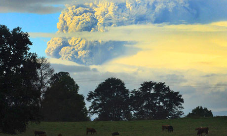
As I am sure most of you are aware, the Chilean volcano chain Puyehue has started erupting for the first time since 1960. The volcano chain is currently spewing smoke and ash high up into the sky. Around 3,500 people have been evacuated from the nearby area, which is 500 miles south of the capital, Santiago, with the area on red alert. The area has been on red alert since Chile experienced a flurry of earthquakes, with an average of 230 tremors an hour. The ash is reported to have reached neighbouring Argentina where people ahve been advised to reduce the time spent outside to a minimum and the local airport has since been closed.

1960 eruption

Current eruption
The last major eruption started on the 24th May 1960, 38 hours after the largest earthquake experienced on record, the Valdivia earthquake,

Glaciers Part 2 - Processes and Landforms linked with Valley Glaciers


Lauterbrunnen valley in Switzerland

A valley glacier is a glacier which extends from a larger body of ice, most commonly a corrie, and moves downslope taking the path of the existing river channel but, over time, the glacier cuts its own wider, deeper and straighter trough.

Valley glaciers are powerful agents of erosion and are directly responsible for the deepening of pre-existing river valleys and so, thereby, they contributed greatly to the spectacular scenery found in many mountainous areas. Due to their erosive ability they have exaggerated, in what can be described as quite a dramatic manner, the vertical difference between the frost-shattered peaks and the valley floors that lay below. This can be clearly seen in mountainous regions in temperate latitiudes as large areas are clear of ice and the landforms have been created relatively recently so  they have not been obliterated by further denudation (stripping of surface cover - applies to both vegetation and soils). The Lauterbrunnen valley in central Switzerland is a classic example. The pre-glacial river valley has been greatly straightened, widened and deepened by the presence of ice and its erosive ability. The resulting glacial trough has a deep U shaped cross-section and the present river is lost within the cavernous spaces of the glacier-carved valley.  The former interlocking spurs have been planed off to give the valley a straight plan with their remnants left behind in the form of high points on the valley sides which are known as truncated spurs. Streams are left hanging from the top of the glacial trough  and cascade down as waterfalls to the valley floor far below.
This image shows not only a truncated spur and how flat the valley floor is but it
also demonstrates the common U-shaped cross section
Although a smooth valley cross profile is created, the dominant feature of the long profile of a glaciated valley is, often, its irregularity. The sudden drop that occurs at the head of the valley is known as the trough end. When the glacier was present, it would have exploited weaknesses within rocks, mainly joints, and variations in resistance between rock strata's as it moved down the valley. The more resistant rock outcrops form into steps or rock bars, whereas less resistant rock erodes into rock basins. Water on the land later fills up the basins to form ribbon lakes, some of which are of great depth and considerable length.

 Exposed bedrock surfaces are normally scarred with fine grooves or more deeply scratched by striations on their upstream sides and quarried by plucking on their downstream sides - making them more jagged. Rock that has eroded is transported, only to be deposited once the carrying capacity of the glacier is reduced due to melting. A ridge deposited across the valley floor at the maximum point reached by the ice forms a terminal moraine. This can be the first in a series of ridges, or recessional moraines with each one representing a point in the valley where the glacier remained stationary for a period of time. The floor of the glacial trough is, often, covered with glacial debris which can be classed as ground moraine.

A moraine is simply a pile of deposits and these depostional landforms can be classified into one of 4 groups depending on their location.
  • Terminal moraines are found at the furthest point reached by the glacier (known as the terminus end)
  • Lateral moraines are found along either side of the glacier
  • Medial moraines occur at the meeting point of two glaciers
  • Ground moraines are disorganised piles  of rocks of various sizes, shapes and rock types
Where ice is still moving freely, some of the mounds of boulder clay are shaped into egg-shaped hills called drumlins. Drumlins are elongated hills of glacial deposits that can be anything up to 1km long and 500m wide. Drumlins often occur in groups known as drumlin swarms (or a basket of eggs like found in the Vale of Eden). They form when the glacier is carrying too much sediement and so deposits it meaning the the debris that the drumlins is comprised of is the sediment which accumulated under the ancient glacier or is accumulating under glaciers at present. This also means that the long axis of the drumlin will indicate the direction the glacier is/was moving in. 

Drumlins in the Vale of Eden, Lake District

A diagramatical plan view of a drumlin
However, in most places the hummocks and mounds are irregular heaps of glacial till and so, in general, these landforms of deposition are more minor landscape features in comparison to those created by glacial erosion.

So, hopefully, this outlines some of the main features found in valley glaciers and the impacts of erosion and deposition and so next I think I will move on to discuss just why valley glaciers have such a great erosive ability with reference to the types of erosion that actually take place.

Friday, 3 June 2011

Glaciers Part 1

I have to admit that I am a bit lost with no college work to do and so I thought that I would try and teach myself the basics about glaciers as I seem to mention them quite a bit on this blog but, on reflection, I don't actually know a lot about them and the processes and landforms associated with them.

So, firstly, a bit of glacial terminology........
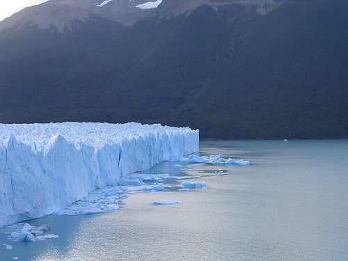
  • ICE :- (I thought that frozen water would be enough, but apparently not) Ice is snow which has been compacted so that the air passages between the individual crystals of snow become sealed, thereby increasing the density. The density has to be greater than 0.85 for it to be classed as ice.
  • GLACIER :- A moving mass of ice on a land suface
  • ICE SHEET:-  An ice sheet covering a plateau region, over an extensive area. Movement around the edges may be faster because of steeper gradients.
  • CIRQUE GLACIER:- After snow has continued to accumulate in a hollow on a mountain side, ice forms and thickens with time. Ice fills the cirque (also known as a corrie) hollow, which is deepened. the glacier may grow to the point where it spills out of its semi-circular hollow into the valley below.
  • VALLEY GLACIER:- A glacier following the line of a pre-existing river valley, fed by cirque glaciers or ice caps. These can be extremely deep and the moving tongue of ice can extend from some distance, down the valley, until it reaches the lowlands or the sea. 
  • PERIGLACIAL:- Applied to land areas which lie around the margins of ice sheets. They are cold areas where permafrost exists either continuously (everywhere) or discontinuously (in patches only).
  • PERMAFROST:- Permanently frozen ground of which only the surface layer thaws breifly during summer. This layer is known as the active layer.
And a few keys dates surrounding the Pleistocene Ice Age.......
  • 2 million years ago = the onset of the Pleistocene Ice Age
  • There have been four major ice advances known as glacials
  • These were seperated by warmer periods , called interglacials, where the ice retreated
  • Anglian is the name given to the first glacial advance in Britain and it occured around 500,000 years ago
  • The maximum ice advance was during the third glacial advance, known as the Wolstonian glaciation in Britain, which ended about 125,000 years ago
  • The Ipswichian (also known as Eemian) interglacial period was particularly warm and so provoke great ice retreat
  • The fourth and last ice advance ended around 25,000 years ago and was called the Devensian glaciation
  • Progressive warming of the Earth (although there have been a few notable fluctuations) has occured since the end of the Devensian glaciation and the end of the Pleistocene Ice Age is usually dated as around 10,000 years ago

Glaciers form when the amount of snow that falls throughout the year exceeds the amount which melts and they can only form above the permanent snow line. Most glaciers originate from a snow patch in a hollow on a mountain side. Once this hollow becomes filled with snow, the hollow itself, is enlarged by various types of weathering and nivation (the proper collective term for all the erosional processes that occur under a snow patch). This weathered material is then easily washed away by snow melt.

Freshly fallen snow has a low density (under 0.5) due to the large amount of air trapped between the individual crystal. However, as more snow falls and the snow patch enlarges, the old snow becomes compacted. More air is then expelled by the successive melting and refreezing and if the snow manages to last a year it turns into higher density firn or neve (which has a density of around 0.7). After further annual snowfall the firn becomes more and more compacted due to the sealing of further air spaces. The crystals start to grow larger, again increasing density, until the density grows to above 0.85 - the point at which snow is considered to be ice. This transition from snow to ice can take up to 200 years in areas like Antarctica as the continually low temperature prevents melting and refreezing, which speed up the process, or only around 5 to 10 years in slightly warmer martime environments such as Alaska.

Glaciers are examples of open systems. Their main input is snow, either from direct snowfall or from avalanches. This snow accumulates in the upper part of a glacier and is stored, in the system, as glacier ice which is carried downslope by the glaciers movement. The main output of this system is water (no surprise there!) and, although some water does evaporate directly from the surface, most water loss results from the ice melt as lower altitudes, or latitudes with higher temperatures, are reached. Further melting occurs at the sides, where the glacier meets rock  with a much lower albedo than the glacier ice itself, and as internal or basal melting. On top of this you also get calving where icebergs break off into streams, lakes and the sea.

Ablation is the term for the net loss of ice and above the snowline, the accumulation of snow is greater than ablation. The point where the systems outputs exceeds the inputs is reached when  the zone in the course of a glacier where accumulation is replaced by the zone of ablation has been reached. When the amount of new snow and ice is excatly balanced by the amount that has melted, a steady state is said to exist and the glacier remains stationary. However, often the position of the break point between the zones of accumulation and ablation changes from year to year (or sometimes over a longer period of time). When the balance is lost the snout (the front of the glacier) of the glacier either advances or retreats. Despite the warming of the Earth over the last 10,000 years provoking greater retreat; colder interludes have allowed for local ice advances. One such interlude was the 'Little Ice Age', which lasted for around 500 years (starting in 1350) and reached its worst in the late seventeenth century when it was nearly cold enough for the re-development of the Laurentian ice sheet in North America (during this period the River Thames, famously, kept freezing over). However, current global warming is encouraging glacial retreat everywhere and calving great icebergs off the Antarctic ice mass with some ice masses being equivalent to size of smaller European countries and Mediterranean islands.

Of great significance to the speed and effectiveness with which glacial processes operate is the size of a glaciers budget. Calculating the budget involves measuring the inputs in the zone of accumulation and outputs in the zone of ablation, as well as any change in the volume of glacial ice in store (sounds a bit similar to the water balance equation we learnt in the rivers module to me). Glaciers in mountainous areas on the western sides of continents feel the full force of the prevailing westerly winds and depressions, like in Norway, and many have snow inputs well above 2000mm (in water equivalent). Lying on the southern edge of the polar region much melting also occurs. A high budget such as this, accompanied by the effects of gravity from the steep relief, encourages faster glacial flow than in continental ice sheets. In interior Greenland and Antarctica less than 50mm of new snow may be recieved during a year, although the intense cold means that little is lost from the system, which means that the ice budget is low.

Ice budget is one of the factors used in the classification of ice masses into either ice sheets and valley glaciers and it also supports the basic thermal division between cold glaciers and warm glaciers. Continental ice sheets are cold glaciers, so called because the temperature throughout the glacier ice remains below freezing point all year round. The ice is therefore frozen to the bedrock below, which slows down the glacier movement to, often, as little as a few centimetres per year. Despite having greater thickness and weight, the lack of movement limits the erosive ability of the glacier and so the amount of glacial erosion that occurs. In contrast, valley glaciers are warm glaciers and many are located in temperate latitudes where meltwater is plentiful in summer - although during winter the some surface ice will melt. This means that water is making its way down through the cravasses in the ice to the base of glacier on many days of the year. Water can also be present at the base of the glacier even when the temperature is falling below freezing point as a result of the weight of the ice above and the friction of movement against the bedrock causing localized melting a the base. The presence of so much water is significant in easing movement and encouraging erosion.

So, thats kind of the beginnings of the the stuff about glaciers that I am trying to understand - sorry I realise that it is a bit long and wordy but I am still banned from talking about anything Geography related at home and so I am kind of just blurting it out on here instead. Next, I think I will move on to the processes and lanforms in valley glaciers and then the glacial processes that exist - with a lot more pictures and diagrams, I promise!

Thursday, 2 June 2011

Geography Picture Of The Day (sort of) - Could ancient bacteria power the world?

The words oil and renewable are not something I think I have ever used in conjunction but this could all change in the near future.....

Oil is used relentlessly across the globe, despite the apparent detrimental environmental impacts, and for many years now the thought of renewable oil has been too idealistic for many to even dare to consider. However, this once idealistic idea, is now getting serious consideration from many scientists.

The above picture just looks like a few tanks filled with a rather vibrant green liquid but this is in fact the ancient bacteria that has got many scientists very excited. Cyanobacteria have already played a huge role in the history of the Earth as, around 2.4 billion years ago, they were the first microorganisms to start to oxygenate the Earth's atmosphere. Now, scientists hope that, after a bit of persuasion from a tad of genetic engineering, they could possiby help us out in the future by utilising our waste carbon dioxide (something that we seem to have an abudance of after the announcement made by the IEA which suggested that last years energy - related carbon emissions reached an all time high) and a little sunshine to secrete alkanes - the crucial ingredient of diesel. This would offer a very 'green' fuel, that could be considered to be solar-powered oil, as, primarily, the microbes could be fed with the carbon dioxide emmited form industry and, this form of biofuel, would not require vast expanses of fertile farm land to be used to grow crops like sugar cane as, due to the need for sunshine, the most commercially viable location for these photobioreactors would be in deserts.

This third generation of biofuels is, with good reason, attracting millions of pounds of investment - especially in America. This latest technology is far from being capable of producing a commericailly viable fuel but, this third generation biofuel is only in its infancy and so there is still hope for the production of a renewable oil and so no longer is the idea of making oil from sunshine one only found in the dreams of many energy producers.