Wednesday, 25 April 2012

Climate Modelling - [based on video notes from Earth: The Climate Wars]

Hello everyone! I hope the revision is going well; only like 8 more weeks of hard work and then it will all be over!!!

Climate modelling is a really, really complicated mathematical area and I got the pleasure of spending some time with many of the worlds best climate modellers whilst at the Met Office. During my time there, understanding modelling was an area that I really struggled to understand and my inquistive nature lead to much confusion on my part (sometimes I really need to just accept things!). Fortunately it seems that we dont really need much knowledge on the modelling but I thought I would summarise what we should have learnt from the documentary we watch - if anyone fanices learning more, this could be a good topic to look into over your long summer holidays (it is on my list for looking at!) and there is some stuff on the blog about it; word of warning though, the maths get very confusing very fast!!!

Here is the links to the three episodes, in order - we only watched the third one in class....
- The worlds first climate models were far from computer based! Instead small scale models were used and these helped to formulate the basics of atmospheric circulation, allowing scientists to generate the basic laws that the atmosphere abides by. However they failed to represent the complex oceanic/atmospheric intergration or predict weather patterns
- Computer modelling was first used to predict the weather on a 24 hour timescale. However, at first it was taking 24 hours to produce a forecast and was not until the 1970s that this became efficient enough and worked reasonably well
- Early on, the models were not deemed that reliable and consequently many climate skeptics used this as a point of attack, saying that as results were not reliable, it could not be said that climate change was happening in reality
- It was not until the 1991 Pinatubo eruption that the models could be tested to see if predictions were accurate. Hansen, a world leader in climate modelling used the eruption to see if the models predictions of the extent of cooling caused was accurate. This event was ideal due to timing of eruption and duration of impacts. The 1980 eruption of Mount St Helens unfortunately came to early to be used to test modelling accurracy due to level of computer technology at that time
- Subsequently, by the late 1990s climate models were deemed, worldwide, as reliable and so their projections viewed with confidence. At this time the models were suggesting that a doubling of CO2 would increase global temperatures by 3C. However, this will never be 100% accurate as resolution of the models still needs improving and modellers still struggle to ensure computers consider influential factors in affecting climate on a smaller, more local scale - this is quite a good explanation of why climate modelling has improved over the years, produced by the Met Office -  Climate Modelling


- There is also the complication of field observations, which are crucial in producing the models, and the increasing level of understanding we are gaining over time. This is an inherent problem with climate modelling and will continue to be as we discover new feedbacks operating in the climate system. The example in the video was based around glacial movements as a once believed 'dead' glacier became 'alive' again and started moving at a faster rate, as the planet has warmed, this has then increased the rate of sea level rise etc. Feedbacks control the extent of change with negative considered stable and positive feedbacks often detrimental due to their amplyfing effect. These feedbacks are very hard to model  so uncertainities will always exisr with modelling; meaning tht changes in sea level, for example, could happen a lot quicker than models predict
- 1961: Lorentz's discovered 'chaos' in the climate sytem by changing degree of rounding used in models and this went on to explain variations in modelling projections. Thousand of runs and run and the general trend is then taken and countries all use different models. The UK uses the Met Offices HadCM3 which was influential in both IPCC AR3 and AR4. Ensemble forecasting is being used to an increasing degree. Ensemble forecasting basically means that all the different runs are started at slightly differing conditions and then by comparing the results it produces a much better idea of what weather events will occur at a given time.
- The discovery of the 'Chaos Theory' made climate scientists realise that there were factors with an influence on climate that they had yet to discover and incorporate in models or to quantify their signigicance
- Proxy data such as Greenland ice cores and pollen and beetles help us formulate the temperature record going back to the Younger Dryas. Understanding how past climates have changed and incorporating this knowledge into modelling helps to make long term prediction more accurate than say the 5 day forecast. The proxy record also indicates that abrupt climate change is possible
- So, far Antartica seems to have experienced the most rapid climate change, especially in terms of sea ice coverage. In 2007 sea ice shrunk by an area 10 times the size of the UK, leading to some scientists predicting that in a decade no sea ice will remain during summertime in this area
- Models say that warming may be slow and steady but history indicates it can be rapid and so we are now experiencing changes happening at a faster rate than model predictions and faster than we originally thought
- Technology has allowed us to deal with some climate condition e.g Las Vegas is built in a desert yet is full of water, thanks to the Hoover Dam which created the 100 mile long Lake Mead. An 8 year drought has been experienced in this region though and models suggest that the drought will continue and, as population expands, water will become scarce and Lake Mead will become ineffective by the late 2020s

So, these are all the notes I managed to take! The basic knowledge we need to have for climate modelling I think is a bit about when they were developed, how they started off etc and then why there are uncertainities and why they are still considered unreliable. Within in this, you need to be able to link in the use of Mount Pinatubo and proxy data to reduce modelling unceratinity but meanwhile realise that they will arguably never be 100% certain. Hopefully I have covered all of this!

'Paradox of Plenty' - Myth or Reality???

Ever since watching the film Blood Diamond, reading some of Tim Butcher's books on various African countries and revising the impacts of colonialism on sub-Saharan African development; I have been thinking about this idea of the 'Resource Curse', also known as the 'Paradox of Plenty'. The general idea is that, in some cases, on balance, natural resource abundance is more of a hindrance than driver of development...... BUT the question is, is this a myth or can an abundance of natural resources significantly hamper development?

Attraction of colonial powers to Africa is perhaps testament to the existence of the ‘Paradox of Plenty’, whereby the abundant raw material reserves easily exploitable and profitable offered by Africa, provoked detrimental European attention, consequential impacts clearly visible in Sierra Leone and along the Gold Coast. This is not only seen in Africa but in other parts of the world too and neo-colonialism in Africa and South America is arguably a continuation of this trend. This is the idea on its very basic level and there are many complexities to it, with economic repercussions, such as economic vulnerability as perhaps countries with one abundant raw material are more likely to rely on that for trading and industry, generating a lack of economic diversity that leaves the nation vulnerable to market fluctuations.

However, as a continent, South America through preferential trading has illustrated the benefits that possessing resources can have and how, if exploited, they can help accelerate the process of development. Therefore, this indicates that if utilised appropriately it can help rather than hinder development so why is it then that having resources has so far failed to aid African development?
The re-occuring development hindrance seems to be the lack of peace and political stability throughout the continent and once peace can be achieved then perhaps development will occur. However cultural differences are so inherent in society, to a degree not previously seen that, when combined with political instability formulates a strong barrier against trade and ensuring environmentally sustainable resource exploitation can be utilised to generated economic sustainablility that can support development.

As with much of this Development and Globalisation stuff, there is no right or wrong answer, but forming opinions on it is crucial so let me know what you think! Does the Paradox of Plenty exist in reality??? And, if so, what can be done to dilute its influence?


Wednesday, 18 April 2012

Quick review of basics of globalisation...

Hello everyone - I hope the revision is going well!!! I thought I better crack on with some revision notes considering our mock is coming up soon!

Before I start though, and this is linked to globalisation, this is quite an interesting article regarding the future for Asia and is probably worth a read as part of your revision - Will This Be The Asian Century?
GLOBALISATION = increasing interconnectedness of the world's economics, culture and politics
    Economic globalisation = existence of TNCs/MNCs and the role they play in the global economy and development; also the existence of the WTO, tariffs and quotas etc

    Political globalisation = existence of trade blocs and groupings of nations
  
    Cultural globalisation = westernisation of other cultures and global marketing strategies

Measuring globalisation:-
We have four methods of measuring globalisation - I don't think we really covered this in much detail in clase but there is a very detailed geofile in the module booklet on it....

1. Globalisation Index
---> 72 countries ranked account for 97% of the world's GDP and 88% of the worlds population
Takes into account:
- FDI, trade, tourism data
- International phone calls
- Number if internet users and hosts
- Political engagementin international organisations

2. KOF Index of Globalisation
Takes into account:
- Actual economic flows and restrictions on trade and capital
- Number of organisations and UN peace keeping missions engaged with
- Personal contacts, information flows and cultural proximity

3. Global Internet Use
---> took 4 years for 50 million internet users to be reached
---> digital divide between countries and between urban and rural areas
---> 75% of all internet users are from MDCs, accounting for only 14% of the global population

4. Geographical Variations In Landlines
---> population size /density/wealth, TNC presence, migration, language, colonial history all influence spatial variation in landline usage

.....interestingly, as with development indicators, all these measures of globalisation yield different results!!!

Factors that have permitted Globalisation to occur.....
1. Development of Internet and Teleconnections:- ensured the spread of capital and quick communication around the globe, practically instaneously

2. Increased Mobility and Containerisation:- goods can easily and cheaply move around, just like people, resulting in transfer of cultures and knowledge also

3. Political Stability and Improved Foreign Relations:- trade agreements and formation of groupings

Patterns of Production, Distribution and Consumption

Production = shift from MDCs to LDCs, provoking de-industralisation in MDCs and industralisation in LDCs
e.g British Steel employed 150,000 which fell to only 35,000 in 2000
TNCs move abroad primarily due to cheap labour costs, and due to colonalism, ability to speak English in large work forces. Also they offer raw materials with minimal environmental legislation. However some re-industralisation of MDCs has occured as they require expertised and being within a group means they avoid tariffs. Although due to globalisation, contemporary production is a truly global affair!

Distribution = all about containerisation!!! This reduced transport costs so much it is possible to have truly global products
e.g Wimbledon tennis ball is now produced in the Philippines to reduce transport costs
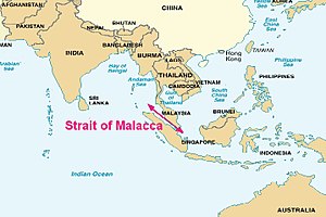
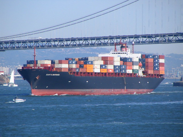
Containerisation is the development of standardised containers which occured in the 1960s, with ships limited by the Malcca Max, and was intrinsic to globalisation.
- 90% non-bulk cargo moved by containers, with 26% from China

Consumption = higher in MDCs as have disposable incomes but fastest rates of growth are in NICs
Richest fifth consume:-
- 45% of all meat and fish
- 58% of total energy
- 74% of all telephone lines
- 84% of all paper
- 87% of vehicle fleet

Monday, 9 April 2012

Development and Globalisation Disussion

Those of you that joined in the discussion last week seemed to enjoy it and I hope you learnt something from it! I must say though I wasn't expecting it to go on for as long as it did! Consequently, I am going to host another one, this Thursday, going live at 7:30pm again and hopefully we can finish off the last bit of development (just aid left I think) and then go through globalisation.

Join in if your around and you can leave questions and discussion points on here in advance!!!

Aid - Is it working? To what extent is it helping LDCs develop?

Hello - I hope everyone's revision is going well, it is hard work isnt it!!! I have had a few requests for this topic, and am going to link in African debt, so here goes.....

Aid is a rather controversial subject as is whether we should cancel LDCs debt...... How effective is the aid we give? Is it actually helping improve peoples quality of life? How dangerous is reliance upon aid? When should we stop giving aid to countries i.e India? Is trade better than aid? Should debts of LDCs be cancelled?
First up though, a few key definitions:
BILATERAL AID = aid that is directly given to the government of one country from another
MULTILATERAL AID = aid that is given by governments to international organsiations which use the money to assist programs in other pooer countries
NON-GOVERNMENTAL ORGANISATIONS (NGOs) = distribute aid in a variety of ways. Many are charities which raise money for development projects, ensuring aid is directed to the people who truly need it
SHORT TERM AID = given in response to a sudden problem within a country - usually a natural disaster
LONG TERM DEVELOPMENT PROJECTS = where help, advice and investment is given on such things like agriculture, energy supplies, infrastructure, education and medical supplies
TOP DOWN AID = where a responsible body, internally or externally, directs the operations 'from the top'
BOTTOM UP SCHEMES/GRASSROOTS INITIATIVES = often funded by NGOs, working closely with local communites and using their ideas and knowledge to bring about more change (more sustainable???)
TRADE = the act or process of buying, selling, or exchanging commodities, at either wholesale or retail, within a country or between countries.
HIPC = Heavily Indebted Poor Countries

Origins of African Debt
- For somer countries, like Ghana, debt began with ambitious development projects in the 1960s following independence and the formation of dictatorships which were a result of vast power vacuums generated
- By the 1970s most independent sub-Saharan countries were seriously in debt
- Oil crisis of 1970s dramatically increased the price of imports
- Worldwide recession decreased the willingness of the USA and former colonial powers to distribute aid in grants
- Consequently, between 1970-1976 Africa's public debt quadrupled
- Debt servicing began to take a substantial portion of GDP
- Demands of debt and structural adjustment often rendered governments less able to supply the needs of their people and less able to claim grassroots legitmacy
- Debt seen as attached to a country, not a government - therefore is transferred even when government is deemed illegitimate

Aid - NOTE: not all aid given is in the form of money!
- Since the 1970s, general trend has been a decrease in aid to Africa (halfed by 1990)
- A large proportion of what is counted as aid by donor countries is known as 'phantom' aid - e.g same 50% of all technical assistance is said to be wasted due to inappropriate usage on expensive consultants, their living expenses and training
- Aid frequently carries restrictions with regards to its use

- Most donor countries use aid as part of a broader forgein policy focused on 'national interests'
- USA has directed aid to regions which pose national security threats whereas Sweden has targetted 'progressive societies' and France to preserve and spread its language and culture
- However, as of 2000, over 2/3 of American aid was tied

Recent Improvements......
- A shift towards more grassroots projects following the successes of NGOs in small scale poverty alleviation
- Norway, Denmark, the Netherlands and the UK have untied their aid from trade agreements
BUT aid has been reduced - Value of OECD aid drops for first time in 15 years, and in the UK where the government announced last year that we were reducing our aid contributions to 0.7% of GNI - Was this a good move?
Whilst on the topic of aid given from the UK, we still give aid to India, despite the fact their economic growth is greater than ours and the country themselves say that they do not need money but that other forms of aid would be more appropriate, this short video clip is worth watching - Do you think we should still be given aid to India?


Trade vs Aid
Whilst in theory, aid sounds like a great idea, in reality this has not been the case and trade is arguably a more sustainable alternative, capable of provoking cumulative causation within a country and accelerating development. Trade is more predictable and a safer option, with aid dictated my economic climate of other countries and aid dependency a dangerous occupation. However, some countries do not have the ability to trade (especially worn torn sub-Saharan nations) or do not have desirable raw materials and for long term development this is problematic as aid often only offers a short term solution.

This area of the module is very debatable, I may try and start of focusing on this area in the next live discussion. The only way to form opinions on it is to read about it; but when you have let me know what you think.....

Friday, 6 April 2012

Reasons for low levels of development in sub-Saharan Africa - Is colonialism really to blame???

The capturing of the Moroccan town of Ceuta in 1415, by the Portuguese, marked the beginning of European colonialism in Africa; a movement with the sole purpose of constructing and conserving colonies in one territory by people from another, reaching its peak between 1880 and 1914, a period infamously known as the ‘scramble for Africa’. The main European colonial powers (UK, Belgium, France, Italy, Portugal and Spain) were attracted to this continent by its abundance of industrially valuable raw materials and the opportunity to exploit them. Despite independence granted to most sub-Saharan countries in the 1950s and 1960s, the vast majority remain LDCs with prevalent social, political, environmental, economic and demographic issues on a multitude of levels. Many feel that development, which is the process of social and economic advancements which leads to improvements in people’s quality of life and general wellbeing, in sub-Saharan Africa has been greatly hindered by colonialism, thus leaving European colonial powers to blame for low levels of development reflected by projections that at least 23 sub-Saharan nations will fail to reach the Millennium Development Goal 4 by 2040. Although at first, it may seem easy to completely lay blame with European colonial powers, other contributory factors are also responsible for the current situation in sub-Saharan Africa.

The ‘scramble for Africa’ saw 1/5 of the globe added to European overseas territories whilst the 1884 Berlin Conference witnessed the superimposition of colonial powers domains on Africa, condensing a previous 10,000 territories into 57. Fragmentation occurred without consideration of psychological or societal divisions and consequently has seen the continent torn apart by civil war, such as the 1994 Rwandan genocide which claimed 800,000 lives. Societal resonance of the ‘scramble for Africa’ has provoked civil conflict, such as the unresolved Darfur Crisis, therefore colonialism can be blamed in part for the low development levels in these countries with both considered one of the 33 classified as LDCs by the UN. The introduction of religion to African society was a secondary impact of colonialism and whilst not aiding unification of these greatly divided countries thus generating social tensions which heighten the probability of civil conflict, their greatest hindrance has been with regards to disease treatment. Religions such as Catholicism do not recognize or accept the use of contraception, making controlling the spread of HIV/AIDS incredibly challenging, with 68% of people with this disease living in Africa. This is proving to be a huge problem in Botswana where 38% of its population are infected and 1/3 of its working force. Appending demographic issues have been developmentally detrimental, with 10 million AIDS orphans in Africa alone and the wider demographic implications of religions introduction to Africa evident within Uganda’s youthful population; a factor that can be linked back to colonialism which has without a doubt de-accelerated African development. Disease, in general, is a huge social problem in Africa, greatly hindering development and whilst some diseases, such as malaria, are a result of Africa’s climate, the impacts that they have on society and thus development have been accentuated by the colonial legacy as in war torn nations aid is increasingly difficult to deliver to those in need, as currently seen in the Horn of Africa, whilst in countries such as DR Congo which has seen 111,971km of road disintegrate into 1000km following independence, the lack of infrastructure hampers aid distribution.

Civil conflict clearly has economic, social, demographic and environmental implications on a multitude of levels with its roots often lying within the political colonial legacy. Upon authorization of independence, power vacuums capable of overthrowing embryonic democracies fabricated by colonial powers led to the formation of dictatorships, with only 9% of sub-Saharan countries classified as democratic. Whilst democracy has often permitted development Botswana, who gained independence in 1966 and have sustained arguably the most stable democratic political system in Africa, have failed to rank significantly higher on development indicators, thus suggesting the dominating development hindrance lies elsewhere. Dictatorships have hindered the formation of stable and sustainable trade partnerships, thus limited export potential, thereby greatly restricting economic growth and therefore development. Inherent cultural differences, which have not be seen to such a degree elsewhere, are the complicating factor preventing not only peace but also preferential trade which permitted 8% growth for the past 5 years in South America and is possibly the best path for Africa to follow. Whilst the occurrence of civil wars cannot solely be blamed on colonialism, its legacy generated favourable conditions for conflict, making it a reoccurring issue continually hampering development.

Attraction of colonial powers to Africa is perhaps testament to the existence of the ‘Paradox of Plenty’, whereby the abundant raw material reserves easily exploitable and profitable offered by Africa, provoked detrimental European attention, consequential impacts clearly visible in Sierra Leone and along the Gold Coast. Unsustainable mining practices have resulted in environmental degradation, accelerated expansion of the Sahara as a consequence of desertification and wide spread deforestation four times the global average, where it would take 260 years for reforms on par with Amazonian ones to be achieved. Political instability and corruption have escalated this as lack of recognised land ownership (only 2% of African forest is under community control), environmental laws and enforcement have enabled the oil industry, for example, in Nigeria to provoke large-scale environmental degradation, impeding development by exploiting the local people and destroying regularity in food sources. Presence of Lake Nyos and Nyiragongo continually pose a threat to countries whilst natural disasters have wiped out all withstanding development, such as the 2002 lava lake burst which consumed 15% of Goma, leaving 120,000 homeless. Constant threat, such as this, further restricts attractive powers of a country to TNCs, whose presence provokes cumulative causation, thereby accelerating development. 50 droughts over the past 50 years and the Horn of Africa currently experiencing the worst famine in 60 years, demonstrates how climate prevails to dictate development, with it linked to multiple influential factors. A recent study links 1/5 of conflicts since 1950 to climate, with a 6% increase in risk of conflict during an El Nino, with every year fighting has broken out in Sudan coinciding with the commencing of El Nino. Although climatic forcing cannot be solely blamed for conflict it is a contributory factor, with the extensive nature of the impacts that climate has allowing it to dominate with regards to determining development; a dominance overpowering colonialism apparent by equally low development in Ethiopia and Liberia, the two un-colonised countries. Africa is an uninhabitable land with climatic extremes occurring with detrimental frequency and unnerving unpredictability whilst absence of regularity in food, water and energy supplies make it practically impossible to settle in an area and kick start development. Restrictions on agricultural productivity, imposed by climate, are most destructive to sub-Saharan development as both the Demographic Transition Model and Rostow Model of Development (although both arguably out-dated and Eurocentric) indicate increased agricultural productivity is intrinsic to initiating development. Although not directly linked to colonialism, it can be argued that political fragmentation has reduced people’s ability, especially the nomadic tribes such as the Rendille, to adapt and deal with Africa’s naturally variable climate. Consequently, subsistence farming persists and without large-scale farming, accompanied by appropriate mechanization, progress will continually be restricted, unless they are able to establish a contemporary route to development. Global climate change threatens to accentuate already large-scale problematic effects of climate on Africa’s development, with as much as a 6C temperature increase, 15-95cm sea-level rise, drastic precipitation reduction and increase in magnitude and frequency of extreme weather events predicted, partially as a result of anthropogenic forcing from industrialised countries; the persistence of climate’s hindrance upon development making it detrimental to a degree beyond colonialism’s comparative contemporary extent.

Economic progression is intrinsic to development, thus by delaying and prevailing to restrict economic growth via siphoning of resource wealth continued by post-independence trade agreements, colonialism has hindered development. 29 of the 40 HIPCs are sub-Saharan with large debts, originating from ambitious development projects initiated by corrupt leaders following independence, rendering governments incapable of investing in health care and education – essential areas with both capable of diluting demographic constraints and provoking the ‘Girl Effect’. As seen by the 1970s oil crisis, increasing globalisation is amplifying Africa’s vulnerability to market fluctuations, initially generated by economic centralisation during colonialism. Attraction for TNCs is limited, due to the afore-mentioned, consequently casting doubts over whether Africa could be the next recipient of the global shift, making it difficult to reduce economic vulnerability currently preventing substantial progression. In some cases aid has been anti-developmental, with tied aid prompting recipients to spend funds inappropriately, such as the Pergau Dam, whilst 60% is considered ‘phantom’. European countries have since ‘untied’ their aid but 2/3 of American aid is still tied, with most recipients those posing national security threats. Imbalance and inconsistencies are hazardous with dependent countries suffering from aid reductions since the 1970s (50% reduction in 1990) and the export side of economies, arguably the most vulnerable, benefitting the greatest, meaning aid fails to directly address people’s quality of life.

Demographically, the impacts of the slave trade were substantially greater than the number actually enslaved (7-12 million) as the targeting of young men hampered agricultural progression, with social and political instability additional consequences. Clearly, the slave trade contemporarily hindered development, with the argument that it made way for colonialism, but in comparison to the colonial legacy and climate, its influence on modern day development levels is minimal, with similarly adverse bites in population pyramids repercussions of civil conflict and ethnic cleansing, as seen with the Rwandan genocide which claimed the lives of 20% of its population. Population growth, rapidly accelerating across Africa, is the greatest demographic constraint and, again, whilst not directly linked to colonialism, introduction of European lifestyles, principally religion, has only increased growth rate which is expected to exceed Asia’s over coming decades.

European colonialism has detrimentally hindered sub-Saharan development, leaving the political map of Africa a permanent liability resulting from the insatiable hunger of colonial powers for raw materials, thus constitutes a reason to lay some blame with Europe for current low levels of sub-Saharan development. Other factors, such as disease prevalence, environmental degradation, corruption, conflict, issues with aid and global market fluctuations have drastically slowed development and, in extreme cases, halted it all together for a period of time. Whilst many of these contributory factors can be linked to colonialism, thus increasing its influence on development, the impacts are likely to only have short-term affects, compared to those of climate, and with international guidance, investment and support along with appropriate technology, stimulating the economic growth required to accelerate the development so long anticipated in Africa is possible. Therefore, it is large-scale natural events such as failed monsoons, floods, droughts, significant natural disasters, sea level rise and global climate change that have played the most dominant role in dictating African development and continue to do so. Unfortunately, these climatic limitations are not evenly distributed around the globe and are likely to increase in severity and magnitude in the future; being concentrated in the areas lacking in the levels of development which enable countries to adapt and mitigate the impacts of natural variability and extremes. So intricately linked are factors affecting development that they formulated a lethal combination which presents on-going challenges to the resolution of Africa’s development issue; absence of peace, due to inherent cultural differences on a level not previously observed, and Africa’s unique environment, continually plagued by variability and extremes, are the greatest complicating obstacles preventing development. Whilst we cannot attempt to fully understand issues facing African development, perhaps combining knowledge acquired from European colonialism, a movement although unsustainable and exploitative saw some advancements, with our understanding of the process of development elsewhere and greater African independence, collectively a solution to their problems could be conceived; allowing sub-Saharan nations to arguably gain from colonialism for the first time.

Thursday, 5 April 2012

Blogging Updates!!!

Hello everyone! I have had countless requests about writing blogs in my other subjects and I also need to find a new method for revising in some of my other subjects, therefore, I have decided to start writing them in my other subjects....

What I learnt in History this week.....

What I learnt in Biology this week.....

What I learnt in Chemistry this week.....

Now, these blogs will not be as detailed, or as frequently updated as my Geography blog as trying to run one is time consuming enough - let alone four! It may take me a while to get the going as well as I am not 100% sure how well they will work in my other subjects! Also they will be used as revision blogs, where I will post mainly revision notes, not any interesting research I do beyond the syallbus or necessarily a lesson by lesson post on what I learn. At present, they are not going to be supported by teacher blogs either but, for those of you interested, they may still be of some use.
Essentially though I am hoping they can be used in the same way as this one, and hopefully be as beneficially to fellow students, so as usual, if you want me to write about anything just let me know!

Also, I quick word about my Geography blog...... I am going to try and reduce the scientific content and keep it to a level required to pass the exam. This means that until the summer exams are over, no more of my own research will appear and I will be talking a lot more about humans. This is going to be hard work for me (so bare with me - I am not quite sure how well this one will go!) but I have been given a few polite reminders now that Geography is all about the interactions between people and the environment and so whilst I may find the physical side far more interesting, unless I can relate it back to how it impacts on peoples lives, then I will not pass the summer exam -  and I think it is about time I start listening to my teachers! So sorry to those of you who enjoy reading about the random stuff I write about but for the next 3 months it will have to disappear (don't worry though I have the entire summer holidays to research all the interesting stuff that the exam board are not nice enough to let us learn about - in their defence I suppose it would be bad if we enjoyed A-levels too much!!!). Most people are probably revising already so let me know what you feel would benefit you the most if I wrote about it. Case studies will definetly be appearing before many of you ask!!! I am currently trying to think of some different, more interesting ways, to revise Geography before I write a post on revision like last year - there are some good books and films out there which would be worth reading/watching; reviews are on the way!

After half term, Millie is starting up weekly online workshops on all the different topics, but in the meantime, after popular request, I am going to and use the method to run online discussions on different topics - especially the human geography topics - as discussion is a great and more interactive way to learn and, as we get frequently reminded, for the exam we need to be able to formulate our own opinions (something that takes me a while!). Join in as and when you can, hopefully they will remain educational throughout! The first one starts tonight at 19:30!

Just incase you are interested, I am retaking Unit 4B (topic doesn't look that bad - anything climate related will grab my attention!!!) so information on that, although less researched based stuff, will appear as and when and if these live discussions work out well, I may try and organise a 4B one over the next few weeks.....
I hope the revision is going well - I think the hardest bit is getting started!

Tuesday, 3 April 2012

Development Discussion

Hello everyone! Right, I am about to try something different, so you will have to bare with me...... after Millie suggested in our last lesson before half term that revising in groups is the best way to do it, I have had numerous questions to do so. Therefore, I thought, why not do them online so, after some consultation with fellow students I have decide to try and run live discussions like Millie does. The idea is that we can discuss things, ask each other questions, share resources and revise together online and it is just easier to host it through my blog. Hopefully, they will prove beneifcal to everyone involved and become a regular thing.

So, the first one is scheduled for this Thursday (05/04/2012) at 19:30. If you are around join in, and spread the word to all other geographers. First topic for discussion is development and globalisation - I have a few discussion starting points in mind, but think of some questions to ask etc and I will see you there......

Development revision - the basics

Hello everyone - this is the first, of many to come, revision posts over the next few weeks, so enjoy!
Development Mindmap
Development Continuum
The development continuum is the contemporary way of viewing development; percieving it as a contiual process and recognising that it can occur in a number of different ways, not necessarily in the way the UK did, as outlined by the Rostow Model of Development. Ranking countries using HDI, a composite indicator, essentially the development continuum is a sliding scale from most to least developed with lots of intermediates such as RICs and NICs; meaning it illustrates the complexities that the Brandt Line fails to display. Therefore it also indicates the importance of the changing roles of countries such as the Asian Tigers, orginally LDCs who attracted TNCs and consequential cumulative causation accelerated development. Now they are mature NICs and their role in the global economy has changed and will change again as they continue to develop and the global shift moves. This idea has replaced older classification (like first, second, third world and MEDC/LEDC) as the use of LEDC and MEDC as discrete groups implied that all countries within that group are of the same development level, which is not the case, and subsequently the development continuum is more reflective of reality.

Gross National Product (GNP) = total value of goods and services for a country's companies at home and abroad
Gross National Income (GNI) = GDP plus or minus the interest and repayments on debt
Purchasing Power Parity (PPP) = measure of the value of the local currency
Gross Domestic Product (GDP) = total value of goods and services within a country (including foreign companies)
Issues with using GDP as a measure of development:
- Inequalities = in many LDCs wealth remains with a few and does not filter down through population
- Informal employment = in LDCs many work in informal employment, such as street vending, so money is exchaged without record
- Subsistence lifestyles = many farmers lead a subsistence lifestyle, so it is impossible to accurately measure income and population

Composite indicators vs Single Indicators
Development is the process of social and economic advancements that leads to improvements in peoples quality of life and general wellbeing, as such when trying to measure it, it is important to not only consider the economic indicators. This realisation, was one of the main driving forces behind moving away from first, second, third world classification and the Brandt Line, to the development continuum. HDI, for example, takes into account GDP using PPP, life expectancy at birth and educational attainment, thus considers several aspects of development. Therefore just because a country is rich, i.e Qatar which has a really high GDP, does not mean it scores highly on HDI, and vice versa as seen with Kerala which has a low GDP but would rank high on HDI. However, there is clearly often a positive correlation between GDP and HDI as countries with a high HDI can distribute funds to health care and education, subsequently raising life expectancy and educational attainment. Despite this, composite indicators make global comparisions a lot easier but some composites, like HPI, are subjective, meaning that it is a less accurate measure of development than solely using GDP. There are some advantages of using single indicators as they do not shroud individual measures and so, with regards to pinpointing what social and economic improvements are required for a country to develop, should also be taken into consideration when determining level of development.

Rostow Model of Development

Produced in 1960, this model can be used as a rough guide to development and, in conjunction with the Demographic Transition Model can be used to formulate population policies. Transitions between both models are very similar, illustrating the intrinsic link between population and development. Rostow suggeseted that all countries could break the viscious cycle of poverty and develop between this 5 stages. However, it is very eurocentric and underestimates the role of colonialism in early development of the 15 countries it is based on.


Tuesday, 20 March 2012

Iceland Fieldtrip 2012 so far....

Iceland so far....... After what seemed like a rather long bus journey to Heathrow, before a three hour flight, we finally arrived in Iceland!!! The first glimpse of Iceland Countryside was that dusted with snow but it still looked bleak when compared to Somerset! First up was a trip to the Blue Lagoon which many of us where a bit unsure about; especially considering it was snowing/sleeting outside!!! But it actually was quite nice, although a tad surreal as the water was lovely and warm but the air temperature was freezing and it was snowing! Although many others and myself are still questioning how it is meant to help your skin by rubbing this sticky grainy white paste on your face, it was quite relaxing after our journey. The teachers seemed to really enjoy it ( or maybe it was because it enabled them to distance themselves from us students!) and throughout today many have remarked that they would like to end everyday with a trip to the Blue Lagoon. We left all smelling of sulphur which apparently we will get used to by the end of the trip! After this us bunch of tired and hungry students travelled to a restaurant for dinner. On the way we got our first glance of the capital and it wasn't quite what i expected as was rather different from UK cities. I think most of us stuck to the burgers but a few tried the minke whale which was an 'interesting' choice in my opinion - I think I may to persuade those people to watch a documentary like the Cove and see how they feel about it then!!! We all had had a rather long stressful day so soon retired to our rooms for much needed sleep.  Up bright and early this morning we drove past the whaling ships - I do wonder why Iceland still kill whales but I am not quite brave enough to quiz our Icelandic tour guide. We past others sites such as the last catholic church, later learning that icelanders have beheaded most of their bishops so perhaps it not surprising only one church remains. Our main activity was caving in lava tubes - Millie took lots of pictures and i will upload mine when get back - and we were all a bit nervous. When I wasn't looking at the floor the features on the Walls were amazing, but it was a bit icy in parts so I personally was sliding everywhere! I think the worst part was when all turned of our torches as it went pitch black. After a while many us just wanted to get out so it proved interesting when the guide told us to go and explore to find our own way out! Millie bravely lead the way as we slid on stomachs to the relentless chant of "are you sure we can get out this way?"! Fortunately we could and Millie was stood at the exit with the camera no doubt catching some interesting photographs as we clambered out of the tunnel and in to the open air at last. However, we were also greeted few snowballs as well. Next moved on to the rifts which were so big and this river where people throw Coins into. Another snowball fight occurred in this World Heritage Site; really setting the tone for the day as whenever snow was around snowballs were launched everywhere, with Millie and Nick the main targets for the boys. Geysirs were next and these were pretty cool - i have some quite good footage which I will post with an explanation. Before going to the hotel we went to see a few waterfalls, and in think we are going to see some more tomorrow. In them quiz tonight a group of students beat the teachers team so I reckon they ate pretty chugged with themselves. A more detailed account with pictures will appear when I get back but i should probably get some sleep. hopefully it will stop raining before morning otherwise we are going to get very wet tomorrow!!!..

Sunday, 18 March 2012

Why are us British so interested in the weather???

Just a quick post before I am off to Iceland for a week!!!

Last week we learnt all about what produces the British weather and arguably one of the reasons we seem to take such an interest in it is that it is best described as changeable, as dictated by 5 different air masses influential to UK weather. Despite the variability, we rarely witness extremes, which is perhaps a fortunate thing considering how badly we seem to deal with them!

Cool Temperate Western Maritime is how we describe the climate of the UK and other countries that have an ocean to the west and are 40-60 degrees north and south of the Equator, and so really the name is quite self-explanatory! Western Canada, parts of Chile and New Zealand also experience this climate but the spatial extent is restricted by relief as mountain ranges (i.e Andes in Chile and Rockies in Canada) force the moist air to rise, clouds and precipitation form but this generates a rainshadow on the eastern side, hence the further influence of this climate inland in Europe (possible link to tectonics!).

Maritime climates are important a places with such climate have warmer conditions in winter than you would expect from their latitude. This is because water has a greater specific heat capacity than land and takes longer to warm ip and cool down, so in winter water keeps the area warmer. However, summers are often a little cooler than expected because the cloud cover reduces the amount of sunlight that reaches the ground. Therefore, it can be argued that maritimes climate was crucial to British development considering we followed the path outlined by the Rostow Model of Development....

This Met Office page is quite good, although designed for teachers, for explaining some of the basics (with even a quick mention of one of my favourites, El Nino!) http://www.metoffice.gov.uk/education/teachers/in-depth/understanding

Air masses are named according to their source, either Tropical, Arctic or Polar, and whether they came from land (continental) or sea (maritime). The UK is affected by Tm, Tc, Pm, Pc and A. When Pm and Tm meet along the polar front, depressions form qith warm and cold fronts that produce heavy frontal and orographic rain.

When I get back from Iceland I will write a post specifically on depressions as their is quite a lot to cover, as well as Monsoons and perhaps a bit of information to help with that lovely assignment Millie has set us (if I have the energy and am feeling nice!). But for now, I am sorry but this is going to as I should probably hunt around for my passport before sitting down to watch Orbit (catch it on iplayer if you have missed any http://www.bbc.co.uk/iplayer/episode/b01d7kd5/Orbit_Earths_Extraordinary_Journey_Episode_1/ ).
If I get the chance, I will blog from Iceland but, if not, I am sure you will hear about it when I return.

Fellow Icelandic Adventurers, see you bright and early tomorrow morning and I promise, I will try and refrain from asking too many questions throughout the week!!!


Wednesday, 7 March 2012

Where would the British be without the Gulf Stream!?

Hello everyone! Hopefully everyone is enjoying the new climate module! Millie has written a very useful and succinct summary (something I never manage to achieve!) post on all the basics we have covered so far so there is no point me doing it to......instead I am going to write a little about the ocean circulation. After a polite reminder that Geography is the study of peoples interaction with the environment I am going to focus on the impact that the Gulf Stream has had on our development and the way society functions; projecting this into the future to examine how we would cope without it; rather than focusing on the science (although this is incredibly interesting, for the exam, unfortunaltely we do not seem to need to know that much - however feel free to ask lots of questions as this links with my EPQ topic).
I will get the sciency bit out of the way first....
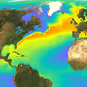
This is a graphic I produced as part of my EPQ and so perhaps goes into a little two
 much detail but the image in the top left hand corner illustrates really well the role of the
Gulf Stream in heat transfer
- Continents divide the oceans up into basins and so this complicates the direction of currents which are already inlfluenced by Coriolis in the same way as winds
- Gyres (large circular) form and move clockwise in the Northern Hemisphere
- Currents are driven by winds, Coriolis and the sinking of cool water near the Poles
- Antarctic Cirumpolar Current is the only current that goes right the way around Earth, preventing icebergs from entering the oceans - this is important when analysising possible threats capable of perturbing the ocean circulation
- Gulf Stream is initiated as water moves across the Atlantic from Africa to the Carribean. As it travels close to the Equator is gets heated. It then gets deflected by landmasses, Coriolis and other factors and so flows along the Florida coast. As it reaches higher latitudes it gets colder and saltier (we say salinity increases) as when ice forms, salt is removed from the fresh water and left behind in the ocean (brine rejection). This makes it more dense so it sinks.
- The Gulf Stream is a surface current but there are also other currents than flow deeper in the oceans. Together they connect all of the world's oceans, transporting heat, and forming the Global Conveyor Belt

I will get into trouble if I talk anymore about the theory but just a quick mention for the deep water circulation (just ignore the next paragraph if you don't want to know anything more than we strictly need to - the bit after is very relevant though)......
Another graphic I made for my EPQ - atleast they are coming
 in handy!
All the currents are linked in a complicated way and are dependent on each other. The sinking of Gulf Stream waters at high latitudes, feeds the crucial Thermohaline Cirulation (THC). Due to the combination of high evaporative salt enrichment and Gulf Stream presence, THC is best developed in the Atlantic. The Gulf Stream transports warm, salty water to the north-east of the Atlantic where it cools, mixing with the cold Arctic Ocean waters. This causes it to become dense enough to sink, both to the south and east of Greenland. The resulting current is part of a larger system that connects the North Atlantic to the rest of the Atlantic, Indian, Pacific and Southern Ocean, where the two main sinking regions spread out in the subsurface ocean, thereby able to influence the world’s oceans from depths of 1000m and below, before the cold, dense water gradually warms and returns to the surface. Basically, the Global Conveyor Belt consists of surface and subsurface currents, sinking regions and return waters which interlink to form a closed loop. The conveyor starts in the Atlantic where salty water proceeds northwards to Iceland, is thermally densified, and thus sinks through the interior to form the conveyor’s lower limb. There are also deep-water flows such as the North Atlantic Deep Water (NADW), which have great influence on our lives. THC is very important. THC engages the entire ocean into the climate system by permitting ocean water to directly interact with the atmosphere (over a timescale of 100-1000 years), ergo, via the Gulf Stream and NADW, moderates the UK’s climate – one that is, consequently, on average, 5°C warmer than countries of similar latitude. On a more global scale, THC influences biome distribution, NPP, sea level, ITCZ movement and productivity of oceans whilst individual currents themselves allowed for the early navigation of the oceans, thus aided development. However, the present pattern has not always existed and is vulnerable to many external factors and cyclic atmospheric changes. Even a significant weakening would have multiple detrimental impacts, with the effects being globally experienced and, as the oceans control the Earth’s climate over decades to centuries, understanding how they are likely to change is crucial in selecting how to appropriately mitigate and adapt to future climate change.

Why is the Gulf Stream important for the UK?
Raises air temperatures, thereby helping to deliver mild winters and cool summers to the British Isles. The warmer waters have a significant impact on North Atlantic temperatures as they give up about one-third of the energy they had previously stored from the sun. The extent of the warmth provided by the Gulf Stream can be seen by comparing the climate of countries at a similar latitude to Britain's - i.e Canada which is a bit colder! It is believed that the UK climate is 5°C warmer than it would be without the Gulf Stream. Warming effect of Gulf Stream prescence enabled agricultral productivity to increase, permitting an acclerated transition through the early stages of the Rostow Model of Development. 
Perhaps the easiest way to understand the benefits of having the Gulf Stream nearby is to summarise the impacts on society if it was absent. Whilst there are many extrinsic forcing factors capable of shutdowning THC, thereby causing a southward shift or even complete shutdown of the Gulf Stream, the most likely is a large freshwater input at high latitudes due to melting ice, consequential to global climate change.........

How would the UK cope without the Gulf Stream?

This area is currently recieving a lot of attention (this is what I focused on when at the Met Office) and model simulations suggest that freshwater forcing of a shutdown, as a result of global climate change, could cause:
- 8C cooling
- Increase in wind speed
- Precipitation reduction
- Storms tending further north so hitting UK with increasing frequency
- 1-2 months additional snow cover
- 80cm sea level rise
- 2% reduction in the UK's GDP
Sea level rise is potentially worrying for the UK as factoring in isostatic readjustment, population growth forcing more onto marginal lands and £130 billion worth of assets currently at risk of coastal flodding, greater than 10% as present, of our coastline would need to be protected. Even factoring in global climate change, the UK would still see reduced precipitation and 3C reduction in temperature. Increased snow cover would drastically decrease mobility, isolate people from an alrady straioned health care amongst other amenities, instigate higher living costs due to restrictions on agriculutre and issues with transporting food (in 2010 one milk company had to throw away 100,000 litres of milk) and cause huge disruption to education (altough, I don't think us students would mind a few more snow days!!!). Lower temperature and prolonged snow cover could cause issues for the UK's ageing population, with 1/4 in the southwest unable to heat their homes, possibly initiating greater urbanisation with cities able to offer facilities in close proximity, more likely to recieve greater funding for protection and the urban heat island effect warming, on average, summar and winter by 5C and 2C respectively. Consequently, a shift in employment could be experienced, with construction work becoming more seasonal and people looking for office-based work that can be completed from home during winter moths. Restricted agricultural and inducstrial productivity, fewer TNC's attracted whose presence stimulats cumulative causation and reduced touristic value, amongst other factors, is projected to generate a 2% reduction in the UK's GDP (-0.1% of global economy) with politicians put under increasing pressure to develop effective contingency plans to prevent societal collapse during protracted snow cover, minimise economci impacts and provide sufficient protection in coastal areas.

Global Impacts???
The two hemispheres and the atmosphere and oceans are coupled in a way we don't need to understand but this means that, despite centralisation of impacts in the North Atlantic, impacts would be globally experienced. A 1C temperature increase in projected in the Southern Hemisphere, which would only be accentuated by global warming. A southward shift in the ITCZ would occur, reducing monsoon intensity/duration over India - worrying as India's water security is already poor, their rivers are reliant on glaciers, sea-level is threatening to displace millions thus increasing population density and India's population is expected to exceed China's by 2030. A 5% reduction in global NPP would be accompanied by alterations in temperate biome distribution and ecosystem disruption whilst with 20% of the world's fisheries dependent on upwelling systems and risng SST's futher reducing ocea oxygen content, food scarity would become prevalent especially with the global population soaring to 9 billion by 2045.

As you might have guessed, I find all of this stuff really interesting but I get the impression all you really need to know is the basic's of the Gulf Stream formation, a bit about how it has helped the UK and, just that society would struggle to sustain current livestyles without it -  so hopefully this all made sense!


Sunday, 4 March 2012

Atmospheric Circulation

Global Heat Budget - Key Points:
- Excess at Equator
- Deficit at Poles
---> Therefore, as basic rules of thermodynamics dictates, all air and ocean currents transport heat polewards

Convection Cells (= essentially the same as that in the mantle)
- Incoming UV radiation heats the ground and is absorbed before being re-emitted as longwave terrestrial radiation.
- Hot air rises, generating low pressure (cloud formation and precipitation results), until it reaches the tropopause where it is forced to diverge.
- As it cools, it starts to sink, generating high pressure (dry conditions)
- Air will then move back to the source region along the surface, from the area of high pressure to an area of low pressure along the Equator

--> If the Earth did not rotate and there was no landmasses on Earth, then two convection cells (one in each hemisphere) would exist, moving heat from the Equator to the Poles. However the Earth does rotate in a anit-clockwise direction, influencing the atmospheric and oceanic circulation pattern......

Coriolis Force
If the Earth didn’t rotate then both the atmospheric and oceanic circulation would circulate to and from the polar regions (high pressure) to the Equator (low pressure) in a continual motion. However, the incessant eastward rotation of the Earth causes a more complex pattern of movement. The circumference of the Earth is greatest along the Equator and so the eastward motion of the Earth’s surface is greatest here; whereas at the poles, where circumference is at is minimum, the velocity is zero. Therefore, if a volume of fluid (or any moving particle) flows north from the Equator; it will sustain its constant eastward momentum but, as it gets within a forever closer proximity to the Poles, the Earth beneath it will gradually slow, thereby provoking air/water to move to the right, in relation to the Earth. Its general effect on flows is to cause them to turn to the right (east) as they progress north from the Equator and to the left (west) as they migrate south from the Equator. This is the Coriolis Effect and its strength increases as the water (or wind) moves further away from the Equator and thus, the distance that the currents flow away from the Equator governs how far, to the left or the right, they ‘bend’. 

- Surface winds/currents moving towards the Equator are deflected to the west
- Surface winds/currents blowing towards the Poles are deflected to the east
- Along the Equator majpr currents flow from east to west
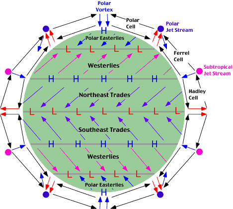
Therefore, in reality there are six convection cells in operation on Earth.....
Tri-Cellullar Model of Atmospheric Circulation
- Intense insolation on the Equator starts the process of convection, leading to the formation of Hadley, Ferrel and Polar Cells
- The same pattern is seen in the southern hemisphere
- Wind pattern can be explained by the rule that air moves from excess to deficit as with each example the wind is blowing from areas of high pressure to low pressure, and then deflected by Coriolis
- Winds are named from the direction they are blowing from
- Trade Winds are so named due to their use in early trade, most infamously the Slave Trade - this provides a great synopitic link to development, colonialism and globalisation   

Air Pressure Systems
- Rising air moves in an anti-clockwise direction and spirals upwards = depression = low pressure
- Falling air moves in a clockwise direction and spirals downwards = anticyclonic = high pressure = stronger of the two movements
ITCZ = Inter-Tropical Convergence Zone

--> The junction near the Equator where the two Hadley cells land based currents meet
- Its position changes with regards to seasons.....
---> British Summer Time = ITCZ north of the Equator so low pressure over India (=rain!)
---> British Winter Time = ITCZ south of the Equator and higher pressure over India
- Over land the ITCZ shifts furhter north or south of the Equator die to differences in the albedo between land and the oceans

I hope this is helpful - let me know if there is something I did not explain very well. On to Jet Streams and Rossby Waves next!!!

Friday, 2 March 2012

Start of the Climate module!!!

This week we started the much anticipated climate module (at last!). Anyone who knows me will know that this is probably my favourite area we study so apologises to my class if my enthusiasm turns into annoyance! This means that I will definetly be providing you with plenty to read!!! So, lets get started...

WEATHER = the state of the atmosphere at a given time and place
CLIMATE = the average weather in a particular place over at least a 30 year period

The atmosphere is a mixture of gases, solids and liquids held in place by gravity, and it can be split into 4 layers differentiated by temperature changes:

TROPOSPHERE:- this zone lies closest to the Earth and is weather processes take place. It displays the highest temperatures as solar radiation warms the Earth's surface which, in turn, warms the air directly above it (via convection, conduction and radiation). However, this effect decreases rapdily with distance away from the surface and air temperature drops by 6.4 degrees Celcius with every 1000m gained in height (= Environmental Lapse Rate or ELR). Wind speeds also increase with increasing altitude as friction with the surface decreases. This is the most unstable layer and contains most water vapour and particulate matter. The end of the troposphere is marked by the TROPOPAUSE which is an isothermal layer where the temperature remains constant, despite the increase in altitude. The tropopause marks the upper limit of the zone of weather and climate and jet streams are found here.

STRATOSPHERE:- this zone is characterised by a steady increase in temperature (known as a temperature inversion) as a result of solar radiation by the ozone layer. The ozone layer absorbs much of the incoming UV radiation that would be harmful to humans otherwise. Wind speeds increase with height towards the STRATOPAUSE.

MESOSPHERE:- temperature declines rapidly to c.-90 degrees Celcius in this zone as there is not water vapour or particulate matter to absorb radiation. It is characterised by very strong winds (often approaching 3000km/hr) and its end is marked by the MESOPAUSE.

THERMOSPHERE:- this is so named because of the increase in temperature resulting from the absorption of UV radiation by the atomic oxygen found at this altitude.

Latitude:
- Latitude greatly affects climate i.e rainforest on the Equator and deserts on the tropics, and its influence on climate affects other things too, arguably like development (think about latitudes at which most developed countries are situated.....)
- Latitude should have the same influence on climate in both hemispheres but it doesn't. Why? Well this is where you can link in tectonics - landmass is not equally distributed between the two hemispheres, with most continents in the Northern Hemisphere. Oceans take longer to heat up than land but are better at retaining heat and so different climates are experienced.

Global Heat Budget
- More solar radiation is always absorbed at low latitudes compared to high latitudes. The Equator recieves more energy as solar radiation strikes the Earth head on.
- At high latitudes more radiation is lost as higher latitudes have a higher albedo so reflect the incoming UV radiation back as longwave terrestrial radiation. The 23.5 degree tilt means that at certain times of the year the poles recieve no insolation, whereas the Equator is always subject to intense insolation. Also, due to the Earth's angle of inclination, at the poels twice the area has to be heated and more atmosphere has to be passed through.
= The net result os a surplus of heat at the Equator

BASIC PRINCIPLE OF THERMODYNAMICS:- Heated substances always move away from their source towards cooler areas, hence the Earths circulatory system. This is the basis of both the atmospheric and oceanic circulation. Remember....
   ---> Substances ALWAYS move from areas of EXCESS to areas of DEFICIT
Factors affecting the heat budget:
  • The Solar Constant ---> varies slightly and affects longer-term climatic changes rather than shorter-term weather variations
  • Eccentricity of Earth's Orbit ---> the eccentric orbit of the Earth around the sun can cause up to a 6% variation in the solar constant (this is linked to Milankovitch cycles which we get to learn about towards the end of the module!).
  • Altitude of the sun in the sky ---> Equator receives intense insolation as UV radiation strikes Earth head on. At higher latitudes is approaches at a more oblique angle meaning there is twice the area to heat up and more atmosphere to pass through.
  • Length of night and day ---> 23.5 degree tilt of Earth means that regions near the poles will not receive any insolation at certain times of the year.
  • Sphericity and the Sun ---> higher latitudes make a lower anlge to the sun and the atmosphere is thicker whilst the poles are further away from the sun than the Equator
The beginning of the climate module covers quite a lot of new concepts so I think I will leave it at this for a while - I think the most important thing to remember is that flows move from excess to deficit as, especially for the understanding winds and the Tri-Cellular Model of Atmospheric Circulation, this rule is crucial....

Intrusive Igneous Activity

---> Not all magma makes it to the surface to be extruded, some of it solidifies underground. The igneous rocks formed can contribute to surface geomorphology through uplift, erosion and exposure at the surface.
SILLS = concordant (replaces a bedding plane)
- Rocks get intruded, hotspot of magma underneath, replaces a layer of bedding, therefore is concordant in relation to bedding planes
i.e Whin Sill, Greenland, Palisades
 
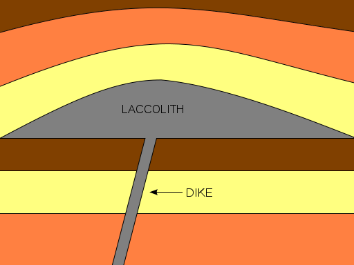
DYKE = discordant (cuts through other bedding planes)
- A vertical intrusion that cuts through bedding planes, therefore discordant in raltion to bedding plane
- Spines of igneous material formed as where dykes cut through bedding rocks surrounding softer rock is easily eroded
i.e Arran dykes

LACCOLITH
- Forms a small upwards, flat-bottomed, dome located within first kilometre of the surface
i.e Montana

BATHOLITH
- slowly cooled igneous rock, greater than 100km2
- produces lots of sandy beaches due to erosion of silica rich granite
- moors very boggy as granite is impermeable to water
- china clay formed by hydrolysis of feldspar within granite
- top of batholith, pressure release cracks, not layers, as weight has been removed
- very popular with climbers and possibilty to exploit geothermal energy = 'Hotrocks' project
i.e Dartmoor to Landsend
VOLCANIC PLUGS
- Quite a lot of castles are built on old igneous intrusive landforms such as volcanic plugs
i.e Edinburgh

GIANTS CAUSEWAY/FINGALS CAVE
- largest basltic lava flows that cooled slow enough to form columnar rock joints, forming hexagnol shapes. Middle parts cooled very slowly comapred to outside
- Gaps that appear between rock columns means it is vulnerable to freeze haw amongst other weathering processes
- Produces very steep-sided coastlines, cliff roughly on a 85 degree angle