Considering that I haven't really written anything of great relevance this past term for AS students and A2 students also need to be able to use the geographical skills introduced at AS, I thought I would start off with going over some of the basics. Hopefully this will be of use to AS students in preparation for your skills exam, you will just have to bear with the possibly frequent references to Poole and its 'exciting' new bridge - so what better place to start then maps, especially as the map at the back of AIB looks like an invitation to construct a Choropleth map!
Maps with located symbols
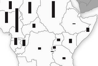
= Located proportional symbols are drawn on maps to show location and number/size of variable
- Symbols are drawn proportional in size to the size of the variable

 - These maps might be used for showing the size of the biggest towns in a region. Often bars or circles are drawn to a suitable scale to illustrate comparative size, and placed upon the map to show the position of the towns, for example.
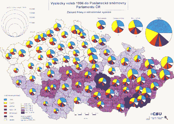
 - Proportional bars are often favoured over proportional circles as they are easier to draw, read and scale. However, if the range in the data (difference between largest value and smallest value) is very big then proportional circles should be used as they offer greater efficiency in presenting large ranges. When complex data sets are used, proportional symbols can be divided (with circles, using proportionally sized pie charts).
- Used to show a limited number of points/areas and should not be used for illustrating spread of distribution
Maps showing movement
- These maps show movement by using flow lines, desire lines or trip lines
Flow lines = indicate a line of movement with its thickness representing the volume of movement and direction the line of flow
 |
| Flow lines |
 |
| Desire lines |
- often used to show the number of people travelling from each part of the catchment area of a central point
Trip lines = simplest map for showing movement, shows journeys from a starting point to a central point
- typically used to map school catchment areas or comparing the 'sphere of influence' of towns etc.
Maps showing distributions
- Distributions can be represented using choropleth maps, isoline maps or dot maps
Dot maps = used to represent spatial distribution where values and location are known by placing dots of equal size on a map.
 - scales can be used, so one dot could represent 10 people or 100 people and a appropriate scale is chosen to ensure the map does not become too crowded
- clusters on the map will give an idea of trends in the data BUT can be tricky to read and are not very precise as dots blur into one, therefore nothing but basic trends and anomalies can be gained from the map
- issues are also presented with where excatly to place the dots
- however, dot maps do have the advantage that they show actually numbers so actual totals can be calculated (by adding up the dots!) - something that cannot be done with choropleth maps as they represent densitites rather than totals
- limitations include the difficulty of counting large numbers of dots in order to get a precise value and the need to have a large amount of initial information before drawing the map
Isoline maps = lines that join places with an equal value for a variable, seperating places with a higher value from those with a lower value
 - ideal for showing gradual spatial change as avoids abrupt changes generated by boundary lines on choropleth maps; hence why temperature, velocity and relief are mapped in this way as they are continuous , without abrupt changes at any point (like population density, for example). There are plenty of examples of isolines, like isovels (water velocity), isobars (pressure), isotherms (temperature), isohyets (rainfall) and contour lines (height) - I am sure AS students have drawn a few isovels themselves over the last term!
- when isolines are drawn close together they represent a steep gradient in the values being plotted, when they are drawn far apart they represent a gentle gradient
- isolines can never cross each other as it implies that the point where they cross has two values
- however, a large amount of data is required for accurate drawing, so in reality many points are interpolated (drawn between two known points to represent the probable point where the line being plotted moght be assumed to occur) and they are unsuitable for showing discontinuous distributions
Choropleth maps = shows spatial distributions, using shadings of different densities to represent different densitites of the variable
 - darker colours indicate higher numbers, although ideally different shades of the same colour should be used
- it is good practice to avoid leaving any areas unshaded - unless they actually have no population at all
- usually desirable to show about four or five different groups - more makes map confusing and fewer does not show enough variation to be useful
- perhaps most commonly used to illustrate population density but can be used for other variables such as indicating differences in land use from recreational land or type of forest cover
- provides a good visual impression of spatial change and shows areas which have similar densities and those with very different densities; therefore allows areas to be compared and contrasted
 Has its limitations though:
 - suggests abrupt changes at boundaries of shaded units, which again does not really occur in reality
- choropleths, on their own, are not suitable for showing total values and so are often used in conjunction with proportional symbol overlays to solve this problem
- sometimes difficult to distinguish between the different shades
- variations within the map units are hidden, and for this reason smaller units are better than large ones
 Goad map = detailed town centre plan which shows every builidng. They can be coloured coded into type of business etc to make it easier to spot land use trends
- looking at land use maps of Poole past and present may be a good idea to see how industry has developed over the years and the extent of urban sprawl etc. There are lots of maps on the A Vision of Britain Through Time website....
Well, hopefully that pretty much covers all the maps we need know about and the skills booklet (if you can find yours from last year!) has some examples of each and how to plot them etc. I think perhaps choropleths maps could come up in the A2 exam, considering we have that blank map at the back of the AIB and population densities in the table at the back, although proportional located symbols could also be an option with divided circles/bars as the table contains three housing options as percentages and various employment figures - I think I would rather a choropleth!
Hopefully, this is of some use for AS students too! I found that be able to read off, and highlight trends and anomalies, from all the maps and graphs was really important - quoting figures is crucial!!!
Next up I think I will do a review of graphical methods of presenting data, before moving on to sampling techniques and the dreaded, by many, stats tests!


