Showing posts with label Volcanoes. Show all posts

Friday, 2 March 2012

Intrusive Igneous Activity

---> Not all magma makes it to the surface to be extruded, some of it solidifies underground. The igneous rocks formed can contribute to surface geomorphology through uplift, erosion and exposure at the surface.
SILLS = concordant (replaces a bedding plane)
- Rocks get intruded, hotspot of magma underneath, replaces a layer of bedding, therefore is concordant in relation to bedding planes
i.e Whin Sill, Greenland, Palisades
 
DYKE = discordant (cuts through other bedding planes)
- A vertical intrusion that cuts through bedding planes, therefore discordant in raltion to bedding plane
- Spines of igneous material formed as where dykes cut through bedding rocks surrounding softer rock is easily eroded
i.e Arran dykes

LACCOLITH
- Forms a small upwards, flat-bottomed, dome located within first kilometre of the surface
i.e Montana

BATHOLITH
- slowly cooled igneous rock, greater than 100km2
- produces lots of sandy beaches due to erosion of silica rich granite
- moors very boggy as granite is impermeable to water
- china clay formed by hydrolysis of feldspar within granite
- top of batholith, pressure release cracks, not layers, as weight has been removed
- very popular with climbers and possibilty to exploit geothermal energy = 'Hotrocks' project
i.e Dartmoor to Landsend
VOLCANIC PLUGS
- Quite a lot of castles are built on old igneous intrusive landforms such as volcanic plugs
i.e Edinburgh

GIANTS CAUSEWAY/FINGALS CAVE
- largest basltic lava flows that cooled slow enough to form columnar rock joints, forming hexagnol shapes. Middle parts cooled very slowly comapred to outside
- Gaps that appear between rock columns means it is vulnerable to freeze haw amongst other weathering processes
- Produces very steep-sided coastlines, cliff roughly on a 85 degree angle

Thursday, 1 March 2012

Minor Forms of Extrusive Volcanic Activity


Geysers and Hot Springs :- Even in areas where vulcanism does not generate active volcanies, water heated at depth in the crust by magma chambers can periodically escape as steam and hot water. A geyser is an intermittent turbulent discharge of superheated water ejected and accompanied by a vapour phase. Where hot water on its way upwards mixes with muds near the surface, a bubbling, boiling mud volcano may form. In some places hot springs have become tourist attractions: in Pamukkale (Turkey), dissolved salts from the hot water are lard down in spectacular calcium carbonate deposits, though the area is not volcanically active (read past post on this here).
Geysers
- hot pressurised water, stored in rock cavities underground which increases pressure
- normally find a small mound surrounding a pool of water. The water is very mineral enriched and when it 'splatters' minerals are deposited, forming the mound.
- pools are incredibly colourful due to dissolved minerals
- periodically form a fountain
i.e Old Faithful (Yellowstone National Park), Geysir (Iceland), New Zealand
RISKS - hot water and sulphurous gases
BENEFITS - tourism and geothermal energy exploitation oppurtunities

Hot Springs
- pool of warm geothermally heated water
- less pressurised water, hence no fountains
- water laden with minerals
i.e Japan, BlueLagoon (Iceland - technically a manmade version)
RISKS - very hot water
BENEFITS - tourism and social
Fumaroles:- Fumaroles are ares where superheated water turns to steam as it condenses on the surface. Personally, I think they look most spectacular when they form in ice, like those on Mount Erebus (this a film review but also contains a description of such fumaroles)

Fumaroles
- superheated water turns to steam, rises and deposits minerals to form chimney-like structures
i.e Stromboli, Erebus
RISKS - hot steam and sulphorous gases
BENEFITS - tourism and mineral extraction

Mudpots
- water geothermally heated, interacts and mixes with mud and surface deposits
i.e Vulcano
RISKS - slightly radioactive and very hot
BENEFITS - tourism


Volcanic Hazards and Management

I am sure everyone is aware of the varying impacts of hazards around the world (Millie has written a very interesting post comparing recovery after the Christchurch, Great Honshu and Haiti earthquakes - it is worth checking out!) and volcanic hazards are no different. Much of this variation is dictated by degree of development but it is important to note that, due to our ability to predict them, no one anywhere in the world should really die as a direct consequence of an eruption. Instead it is the secondary impacts that cause the most problems.

Gas
- All volcanic eruptions are caused by gas escaping from magma with the viscosity of magma determing the ease at which gases escape
                - High viscosity = explosive eruption with pyroclastics
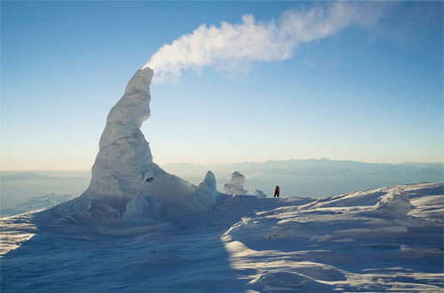
                - Low viscosity = effusive fumaroles with fire fountains and lava
- Active volcanoes produce large volumes of water vapour, carbon dioxide, chlorine, hydrogen sulphide, hydrogen, helium, hydrogen monoxide, hydrogen chloride, amongst other nasty gases. Fortunately they rarely reach lethal levels in populated areas but as carbon dioxide is denser than air it can collect in depressions which allow concentrations to build up to a level capable of suffocation.
- Lake Nyos, 1986, is the only example of gas killing people.
                - August 21st, 1986, limnic eruption occured, triggering sudden release of 1.6 billion tonnes of carbon dioxide. As carbon dioxide is 1.5 times more dense than air, the cloud suffocated some 1,700 people within 20km of the lake and 3,500 livestock. A further 4,000 people fled the area, with many developing health problems a as result of exposure to this hazard.

--> Degassing the lakes is a form of managment as by capturing the gas the risk is minimised. Important to note that 1986 was the first limnic eruption we have known to occur as there is no record of past eruptions. Therefore we were unaware that such a hazard existed. Now, degassing columns have been placed into the lake. The same has been done with Lake Kivu which contains methane. The difference here is that the degassed methane is beign used to run powerstations to provide electricity, aiding development.

Lava Flows
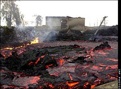
- Only basaltic lavas are 'runny' enough to travel far from their source. Although all lavas slow as they start to cool, basaltic lavas often destroy property but rarely kill people as flows are predictable
- Nyiragongo is the only example where people have died -  in 1977, 70 people were killed. Most recent eruption was 2002 when 300,000 people were forced to flee into neighbouring Rwanda and 15% of Goma was consumed.

--> Management is possible as was seen during the 1973 eruption of Heimaey (Iceland) and Etna. In both cases the lava flows were diverted away from populated areas.
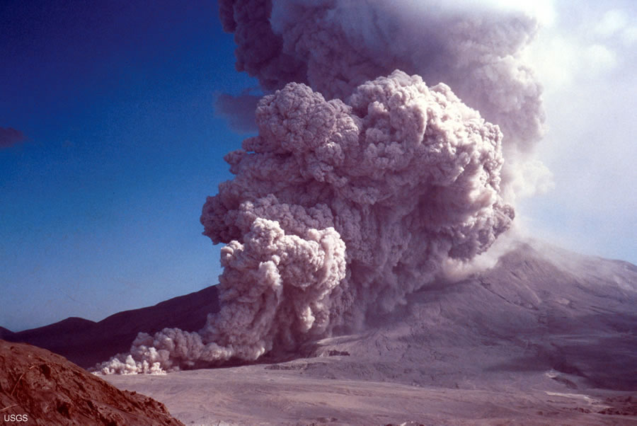
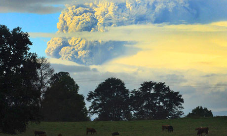
Pyroclastic Flows
- Mixture of rock, gas, magma blasted out of composite volcanoes.
- Viscous lavas
- Travel at over 300mph with inner temperatures of 500C
- Deadly killers as can affect up to 40km from the vent, travelling in all directions
- Examples = Mount St Helens, Pinatubo and Unzen

--> Only management is effective evacuation, which is reliant on good prediction, as nothing can really stop a pyroclastic flow

Lahars
- Can be set off by the eruption by the melting of a summit glacier - e.g Nevado del Ruiz and Iceland (jokulhlaup)
- Or caused by rain mixing with ash and causing massive continuous flooding - e.g PInatubo, although eruption was last in 1991, a tropical cyclone passed over the area last year provoking a lahar

Landslides
- Landlisdes set off by the eruption can cause destruction
- Mount St Helens eruption was caused by a landslide
- Landslides also can cause tsunamis on islands and coastal volcanoes i.e Stromboli and Krakotoa

Ash
- Ash causes total destruction for hundreds of square kilometres
- Building collapse is most common cause of death due to volcanic hazards
- Destroys land and kills animals. Contaminates water supplies and sets like concrete with rain
- Can cause global cooling and reduce rate of sea level rise - e.g Pinatubo cooled world temperatures by 1C for 5 years
- Economic impacts with disruption to air travel - e.g Iceland E-15 eruption

Good Managment Case Studies
  • Lava flows of basaltic eruptions = Etna and Heimaey
  • Channelling of lahars = Japan
  • Prediction success = Pinatubo, Unzen and Montserrat
  • Prediction failure = Nevado del Ruiz, Mount St Helens
As with any hazard management can be split into several catergories:
- Prediction - now very advance with volcanoes
- Hazard mapping i.e of past eruptions
- Monitoring - many of the worlds volcanoes, especially those near densely populated areas, are monitored
- Evacuation plans and procedures
- Education
- Hard engineering management such as lava flow diversion

Key Points:
- The variation of impacts is controlled by the type of volcanic eruption (therefore in an essay on hazards you could slip in some of your knowledge on silica content etc.)
- Further variation is provoked by degree of development
- If we knew were the volcanoes were it is unlikely we would have settled there! However, the offerded fertile lands to earlier settlers and since then many have grown into densely populated cities. It is unlikely that we will just move the cities away from the hazard (will be interesting to see what decision is made with Christchurch though!) and as population continues to expand more people will come into contact with the risk. Therefore there is an increasing need for management.
REMEMBER:- A hazard does not necessarily put you at risk.....
Hazard = the way in which an object or situation may cause you harm
Risk = the chance that harm will occur
Disasters only occur when people come into close contact with a hazard, hence why the risk will increase as global population expands and more are forced onto marginal lands.
- Nowadays people shouldn't really die directly from volcanic hazards due to our ability to predict them, but people do - why?
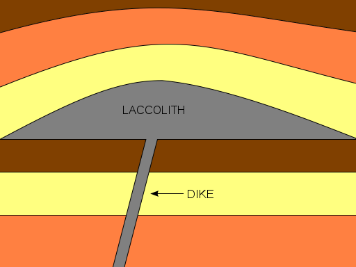


Tuesday, 28 February 2012

How are lava type, volcano shape and eruption style linked?

So, I have covered all the boundary types and seeing as I have had a lot of requests on this topic I thought I would move on to the different volcano types and what dictates their formation. Sorry that there has not been much activity on here for a while but there is lots on its way to make up for it!!!

I have to admit that I think the fact that silica, alone, can be used to link all this volcano stuff together is pretty amazing (and surely I can't be the only one!) but how excatly is this the case......

How are lava type, volcano shape and eruption style linked?

Monday, 28 November 2011

Plate Tectonics - the basics...

Seeing as we have just started vulcanicity, I thought it would be a good time for me to re-cap on what we should have learnt so far (we have covered quite a lot of new stuff, especially for non-Geologists such as myself, so this will probably have to be written over a series of posts)......

First up, we need to have a basic understanding of the evidence that exists which supports the theory of plate tectonics. As simply as it can be put, we have older evidence and newer evidence.

Older Evidence:
- Biology - same fossil formations found in different parts of the world
- Geology - rocks of same afe and type and displaying the same formations found across the globe. Similar glacial deposits are found in Antarctica, South America and India, now many thousands of kilometres apart; striations showing the same orientation when the continents are reunited, are found in Brazil and West Africa.
- Climate - fossils of plants that live in tropical conditions found in Antarctica, with it incredibly unlikely that tropical climatic conditions ever existed in Antarctica's current location. PLaces apart across the globe contain coal deposits of similar age that were formed in tropical conditions; they are no longer in tropical climatic belts therefore must have drifted apart since the Carboniferous period.

New Evidence:
- Discovery of the Mid-Atlantic Ridge (1948)
- Paleomagnetism and the reversal of the Earths magnetic field (1950s)
- Seafloor spreading and then carbon dating of the seafloor rocks (1960s)
After passing the Curie Point, iron ions within the lava will
align to magnetic north......
.....This means that as the seafloor has spread, and magnetic reversal has occured in
the past, stripes are visible on the seafloor, preserving a record of the Earth's polarity at the time
of the lava cooling. This has helped to support the idea of seafloor spreading as the youngest
 rock is located nearest to the ridge.

Hopefully, this timeline summarises the key dates and discoveries we need to know about!


Structure of the Earth:

1. Crust :- it is the upper layer which is solid and is divided into 2 types;
       - Oceanic crust = mainly basaltic in nature and around 6-10km thick. It is more dense and younger than continental curst
       - Continental crust = composed of a wide variety of igneous, metamorphic and sedimentary rock. Can be as much as 70km thick.

2. Moho Discontinuity :- boundary between the crust and the mantle. Average depth of 8km below oceanic crust and 32 km below continental crust. Has density similar tp an olivine-rich rock such as peridotite and so is less dense than the mantle; as such seismic waves accelerate in this region.

3. Mantle :- below the crust. Upper part is solid and is part of the lithosphere. Below this is the asthenosphere which is partly molten and can flow, whilst the rest of the mantle is liquid.
       - Lithosphere = consists of the outer solid part of the Earth, which includse the crust and rigid upper mantle. The lithosphere is about 100km thick, although thickness is age dependent (oldest=thickest). Lithosphere below the crust is brittle enough at some locations to produce earthquakes by faulting, such as within subducted oceanic plate.
      - Asthenosphere = ductile part of the Earth just below the lithosphere, including the lower mantle. It is about 180mk thick. Relatively slow seismic movements compared to the lithosphere.

4. Gutenburg Discontinuity :- boundary between the outer core and the mantle. Where thermal nuclear reactions occur that start convection cells off in the mantle, sending plutons of hot magma upwards. Located at a depth of about 2,800km and marks a sudden increase in density.

5. Outer Core :- liquid iron-nickel alloy, temperatures of over 6000C.

6. Inner Core : - Solid iron-nickel alloy. Even though temperature is higher than the outer core, the pressure produced by overlying weight is strong enough to prevent the liquid state.

How do we know this? Well, studies of earthquake waves, with regards to the velocities and paths of such waves,  depends on what excatly it is they are passing through. P waves can travel through anything but S waves can only pass through solids; so by studying these waves it has been possible for scientists to determine the physical composition of the Earth's interior.

Convection Currents = Driving Force

- Occur in the mantle, very slow convection currents flow in the asthenosphere
- Provide horizontal forces on the plates of the lithosphere, with high temperatures causing updoming and tensional forces pulling the crust apart
- Start in the Gutenburg Discontinuity where thermal nuclear reactions send a pluton upwards

Boundary Types

The Earth's lithosphere is split up into 7 major plates, and around 14 minor ones, with some plates composed of both oceanic and continental crust. Between these plates are boundaries/margins, and there are three main types.......
----- I am going to do a seperate post for each boundary type but, in short:-

- Divergent (constructive) = Plates move away from each other, generating tensional forces. Consequently, characterised by shallow-focus earthquakes and volcanoes producing basaltic magma, forming new oceanic crust. Produces oceanic ridges and rift valleys.

- Convergent (destructive) = Plates move towards one another, generating compressional environments, therefore are characterised by deformation, volcanism, mountain building, seismicity and mineral deposits. Three possible types:-
                                                                - Oceanic vs Oceanic
                                                                - Oceanic vs Continental
                                                                - Continental vs Continental
- Conservative = Plates move laterally past each other, or in the same direction at different speeds. Produces a lot of shear stress as lithosphere is neither destroyed or created. No volcanic activity but lots of shallow-focus earthquakes, intensely shattered rock and characterised by production of faults parallel to plate movement.

Friday, 19 August 2011

Success in predicting an underwater eruption

Being able to predict any form of natural hazards is an achievement and, for the first time, scientist have successful managed to predict an underwater eruption.

What does the aftermath of an underwater volcanic eruption look like? Well, if you have just watched the above clip you will have noticed that vents are releasing cloudy water months after the blast and the seafloor is covered in hardened lava.

When scientists found this sight, they were not at all surprised by it as they had forecast this event, making it the first successful prediction of an undersea volcanic eruption.  Axial Seamount, off of the Oregon coast, has been discovered to behave in a more predicatable manner than previously thought, and than most other volcanoes. The reason for this is believed to be due to its robust magma supply, accompanied with a thin crust, and location on a mid-ocan ridge spreading centre.

When the volcano last erupted in 1998, the bottom of the crater subsided as magma moved upwards. The team predicted that it would erupt again once it attained the same level again. Based on a series of pressure measurements that showed the volcano was inflating, they forecast that this would happen before 2014. It is believed that the volcano erupted on the 6th April this year. Scientist were able to generate this prediction as it is the only volcano on the seafloor whose surface deformation has been continuously monitored throughout an entire eruption cycle.

Sunday, 5 June 2011

Geography Picture of the Day - Puyehue volcano chain

My Geography Picture of the Day, today, is an easy choice if I am honest..........
Click on the link for the news clip from the BBC, accompanied by their report
http://www.bbc.co.uk/news/world-latin-america-13657187
As I am sure most of you are aware, the Chilean volcano chain Puyehue has started erupting for the first time since 1960. The volcano chain is currently spewing smoke and ash high up into the sky. Around 3,500 people have been evacuated from the nearby area, which is 500 miles south of the capital, Santiago, with the area on red alert. The area has been on red alert since Chile experienced a flurry of earthquakes, with an average of 230 tremors an hour. The ash is reported to have reached neighbouring Argentina where people ahve been advised to reduce the time spent outside to a minimum and the local airport has since been closed.

1960 eruption

Current eruption
The last major eruption started on the 24th May 1960, 38 hours after the largest earthquake experienced on record, the Valdivia earthquake,

Tuesday, 22 February 2011

Encounters At The End Of The World - A students review

Just over a week ago now Millie watched this film and when she wrote her review she stated that it was one of her favourite films behind Harry Potter. Anyone who has been in a classroom when Harry Potter has been mentioned when Millie was around probably got the impression that she likes it rather a lot! So, as soon as she made this comparison I thought she must really really rate this film and so I thought I would watch it to see if it is any good......

The documentary consists of surreal footage of both above and below the ice and interviews with some interesting (and rather unique) people that work in Antarctica who are clearly very passionate and enthusiastic about the work they do. The footage of the scenery and the wildlife is unbelievable and the noises of the seals, the ice and just pure silence are literally out of this world. The documentary provides an insight into the research that is being conducted in Antarctica which ranges from studying the nutritional content of Waddell seal milk and neutrino detection to the study of the ice caps. All of this research is vital, especially the studies on ice caps as they hold the potential for us to gain a better understanding of both past and future changes within the climate.

I am a bit of an animal lover and so the bits involving seals and penguins really interested me but the bit that grabbed the most of my attention was the volcano stuff - especially the images of inside the fumaroles. Before watching this documentary I had never even heard of fumaroles before and to be honest I don't really know a lot about volcanoes. I still can't get over the sheer size of the fumaroles that are dotted around the sides of Mount Erebus. The documentary didn't really explain how they formed the massive ice towers or the caves but, as I couldn't get the images of the vast caves and towering chimneys out of my head, I just had to try and gain some understanding of how they are formed (sorry - I get a little enthusiastic about many things and my hunger for knowledge means I hate the feeling of not knowing!). Fumaroles are openings in the Earth's crust that emit steam and gas. The steam is created when superheated water turns to steam because the pressure of the water drops as it emerges from the ground. However if a lot of groundwater is present the fumaroles can turn into hot springs which provide a source of water that is heated by the escaping gases. The gases released are not always toxic and this is why scientists are able to enter some of the fumaroles on Mount Erebus. Fumaroles can occur individually or as part of a fumarole field. A fumarole field is an area that consists of both hot springs and gas vents that are created because the shallow location of magma and hot igneous rocks means they interact with the groundwater and release gases. In Antarctica the gas and steam that seeps through the openings in the Earth's crust cause the snow above to melt and this carves out huge caves within the snow. As the steam rises it freezes and chimney like features are created. Over time these get bigger and bigger and some of the fumaroles on Erebus are estimated to be two stories high (I think this is kind of the basics).


Anyway back to the review.......
I have to admit that I totally agree with what Millie said in her review about how she didn't like how developed McMurdo was. I understand the importance of the research that is being conducted in Antarctica and that some infrastructure is required for this to happen but, to me, it just seemed wrong to see a construction site accompanied by lots of heavy machinery in the backdrop of Antarctica - an area that I previously (and maybe naïvely) believed to be almost like a different world that was free from human influences and the encroachment of civilisation.

Overall I think this film is definitely worth watching as it provides an insight into the work that is being conducted in Antarctica, what it is like to live there and what Antarctica is like in general. Apart from a few links to climate change it is not necessarily relevant to our current module but it did make me think about the fact that if global temperatures rise, in say 30-50 years’ time (or maybe even less, who knows) the landscape, that is portrayed in this documentary through some simply stunning footage, is going to look very different to what it does today.