Tuesday 31 May 2011

Waterspout off the southeast coast of Australia

When I first started writing this blog, I didn't really know how to write it and one of the suggestions made by one of the Geography Teachers was to watch the news and then write about that news story/footage in more detail. So, I thought I would give it a try..............
This footage was shot yesterday and was shown live on an Australian news channel. According to the reporter the scientific reason for the occurence of a waterspout is when there is a "bit of wind going around in circle" but I think there is slightly more to it than that.......

So, what excatly is a waterspout? Waterspouts are intense vortex funnels, which can sometimes be destructive, with a small width, that occur over water. Like dust devils and tornadoes, waterspouts are convective vortices whose circulations are driven by convection forming rising shafts of air. Proper waterspouts form over the water and will dissipate almost immediately upon touching any landmass. You can also get Tornadic waterspouts which are tornadoes which have been produced by severe thunderstorms and touch down onto or cross a body of water.


This is a cumulus congestus cloud. They are heap clouds which
 have a large vertical and horizontal extent which are often said to look
 like a cauliflower as they have a flat bottom with a rounded but distinct top.
Waterspouts develop beneath the lines of rapidly growing, shallow cumulus congestus clouds (normally around 3000-4000m deep and 600m above the surface).  Most form in very warm subtropical waters, although some can form in large lakes and along the coastline. The vital condition for their formation is a much warmer surface water temperature then the air above. Therefore they form most during summer in subtropical waters or during late summer in lakes and along the northern coastline. A waterspout develops when a shaft of warm air forms at the water surface and begins to rise rapidly, which makes it spin. The waterspout funnel then begins to develop at the surface of the water and then builds up towards the sky. It often looks as if the waterspouts are sucking water up, from the water surface, but it is actually the condensing of water vapour in the rotating vortex and this makes the waterspouts visible. Waterspouts can spin clockwise or anti-clockwise and at the base of the funnel, the water is stirred into mushroom shaped water sprays.

It is easiest to understand them by looking at a diagram:

1. Water temperatures have to be around 26/27 degrees Celcius
2. Rapidly rising warm air forms lines of towering cumulus clouds
3. Rotation, either clockwise or anit-clockwise, begins as air converges on the column of rising air
4. A dark spot, which is normally only visible from above, appears on the ater surface. This is the first sign of a waterspout developing
5. Surface winds of around 50mph can produce sea spray at the base of the waterspout

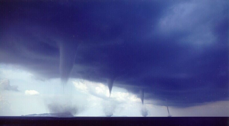
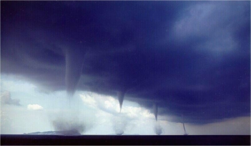
 Compared to tornadoes, waterspouts are less destructive as they are less well defined. They can pose a threat to infrastucture just off the shoreline or boats, as they have the power to overturn them, but, because they are slow moving and highly visible, boats are normally able to steer away from them and so any possible danger.


Geography Picture Of The Day - Terraces of Pammukale

I thought I would try some new, different things on this blog to try and make it a bit more visual as I realise that, normally, I just write a lot and so it doesn't look that exciting. Firstly I thought I would, as often as possible, write about a geography related picture that has interested me or made me stop and think.........


These are the snow-white terraces of Pamukkale in south west Turkey and I have never seen anything like these before and, because they look quite unusual, they caught my eye in a book I was looking at the other day. Pamukkale itself means 'Cotton Castle' which isn't hard to see why when you look at some of the images of these terraces.

 So, how do they form? Well, Pamukkale is located along a tectonic fault line and the area is full of hot springs. These hot springs are crucial in the formation of the terraces as they are made of travertine (a form of limestone), which is a sedimentary rock that is deposited by the hot water. The water temperature in this area is, on average, around 36 degrees Celcius and is enriched with a number of different minerals. The presence of different minerals effects the colour of the travertine which can also be red, tan or cream in colour but when free of impurities it is white. The mineral rich water leaves the springs, and flows down over the terraces. As it does so, the minerals in the water react with the oxygen in the air and carbon dioxide is produced and released and this degassing of the carbon dioxide leads to the deposition of calcium carbonate. Evaporation then leaves behind the calcium carbonate and other minerals which harden into a chalk-like sinter. This calcium carbonate accumulates everywhere, covering every surface, stone and rocky slope in reach. Therefore, layer by layer, the landscape around the hot springs has whitened and hardened and the terraces, themselves, are continually resculpted by the warm subterranean springs that seep through the surface.

Are current farming practices sustainable?

Farming is something that affects everyone in some way or another and living in Somerset means that, for some of you, farming is part of your daily lives. My stepdad is a farmer and so farming has been a part of my life since I can remember  and we own sheep and chickens and we grow vegetables for either our consumption or the sheeps. Over the last few months I have read numerous articles about the problems that are going to arise, in terms of food supplies, as the global population continues to grow. I have also been reading (yes I know, I read rather a lot!) the weekly articles, which is part of a year long investigation that have been published in the Farmer's Weekly which discuss farm energy and the ways in farms could exploit renewable energy. All of this, accompanied with some of the things that Al Gore has mentioned in his second book Our Choice and my personal experience of farming, has made me really question whether or not our current farming practices are sustainable and how they are going to have to change in the future.

It is a well known fact that the global population is expected to rise to 9 billion by 2050 and, as many people starve everyday in the world at present, many are worried that we will struggle to feed 9 billion mouths if we continue to farm the land in the same way that we do at present. Also rising sea levels threaten to claim the world's most fertile farm land which would put even more pressure on farmers to efficiently grow crops as it takes roughly 3000 years for a metre of workable soil to form. On the other hand, some people take a more optimistic view, and believe that we already produce enough food to feed 9 billion people (one article I read even went as far to say that we currently produce enough food to feed 15 billion!) and that we just need to reduce the amount that we waste. It is estimated that in developing countries 30% of their harvest is eaten by rats or insects or rots in grain silos and in developed countries we throw away 25% of our food, uneaten and that each 'rich' person waste 800 calories of food each day (for more on reducing waste see previous blog post on 'can the world cope with the growing population'). If we could reduce this waste then perhaps not as many people would go hungry each day. To reduce wastage in developing countries it is going to come down to improving their farming methods but in developed countries I think a change in attitudes is required. I was discussing this whole issue with my family a few weeks ago and in relation to reducing waste, we all agreed that the power that supermarkets have needs to be reduced and we all need to care less about aesthetics. Next time you go to a supermarket, look at the fruit and veg and see if you can notice how it is all practically the same size and shape and colour. How much fresh food do you think is wasted because it either fails to meet the aesthetical requirements of supermarkets or it is not brought before it reaches its shelf life? I am guessing that it is possibly quite a lot and this does not just occur in supermarkets as I am sure that many of us are guilty of throwing out untouched food if, even if it is fine, but has just passed its best before date. Reducing waste could be one way of ensuring we can feed the growing population but, in the future, other factors are likely to provoke farming patterns to change.......

As we  worked our way through the energy module, it became increasingly apparent that life as we know it cannot exist without the use of fossil fuels and, as oil reserves in particular continue to dwindle, farmers are going to have to change the ways in which they use the land. All pesticides, fertilizers and herbicides are produced from oil and since the mechanisation of farming, large machinery has played a large part in food production. The use of all of the above is going to have to be reduced as oil reserves run out. An increase in organic farming, at first glance, may seem like an attractive alternative as fertilizers, herbicides and pesticides are not used on the crops. However, due to the fact that you are not permitted to use such things, tractor hours are drastically increased which makes it debatable whether or not increasing organic farming would actually consume less fossil fuels. So, how are we going to manage to increase productivity without the use of fertilizers and pesticides or large machinery. Is hydroponics going to have a play a bigger role in food production or is the way we utilise land going to have to change?

Energy plays a crucial part in farming as we know it, especially fossil fuels, but farms do have huge potentails in terms of renewables. I feel I need to mention the fact that biomass and biofuels are becoming increasingly popular in the UK but, as expressed previously (see 3 quick questions I have been meaning to put forward in relation to the energy module.......Can biofuels offer a sustainable alternative to fossil fuels? Do developed countries have the right to limit the amount of fossil fuels industralising countries use? And finally Does oil fuel aggression?) I question whether or not biofuels are a sustainable option for the future. Biogas is becoming increasingly popular amongst farmers, especially in Germany who now have 6000 fully functioning plants. This popularity has been provoked by the government's feed-in tarrif scheme which gives finicial support to those considering developing a biogas plant on their farm.  In the UK, wind turbines are slightly more popular at present, as they can be constructed on grazing land as they do not pose any potentail threat to lifestock. Farms, due to the UK's FiT scheme, are starting to exploit wind energy by constructing a few small 10-15kW turbines on their land to help generate some of the energy that they consume for lighting and heating etc. Solar energy, especially in the south east, is also proving to be increasingly popular with farmers.

At present farmers, within the EU, are paid subsidies to manage conservation and preserve the surrounding environment and, due to the costs involved with farming, the vast majority of farmers comply with these requirements to ensure they get the subsidies. These requirements often affect the size of land available for arable farming as, for example, farmers qualify for differing levels of subsidies depending on whether or not they leave a 6ft or 12ft margin around the field for conservation. The issue of whether or not we will be able to continue to preserve and protect the environment in this way when we have 9 billion people to feed featured greatly in the discussion I had in my family and my stepdad, who recognises the importance of preserving the environment for future generations, questions whether or not we will be able to continue to protect the environment in this way in the future without comprimising our ability to feed the people that live in it. Perhaps this is going to come down to deciding which  areas to extensively farm and which areas to conserve. For example, a recent government-backed report suggested that Wales should convert at least 20% of its farmland back to forestry because its agriculture is so unprofitable. So, what if we reduce our use of land and turn to hydroponics instead? Many Japanese farmers, due to a lack of flat fertile land, have tried this method of farming to increase yield and so is this the way for the future?

Another influential factor, that needs to be considered when discussing the future of farming is changes to climate. Currently arable farming in the UK is centred in the south east whereas pastoral farming occurs elsewhere where the climate is not as hot. However, with the predicted rises in temperatures experienced in the UK over the next 20 - 30 years, Scotland and Northern England are likely to experience the higher temperatures that are required to switch from livestock to higher value arable crops. Therefore, it will not only be a lack of fossil fuels that will provoke changes to farming but also changes to the climate which ultimately dictate what and when crops are grown.

From this, I think it is clear to see that our current farming practices, for various reasons, will not be able to be continued in the future and we have to change in response to a lack of resources, growing global population and an ever changing environment. Despite it being easy to say that they will have to change; it is harder to predict what exactly they will change to. Are we likely to turn to hydroponics, or is this unlikely as freshwater becomes scarce? Is organic farming the future of farming in the UK? Or are we going to have to revert back to subsistence farming to reduce the transportation of food and the need for large machinery?

Our Choice

Our Choice is the second book by Al Gore, which follows on from An Inconvient Truth. As explained in my book review of An Inconvient Truth, his first book identifies the problem and provides some of the evidence used by scientists to prove that global climate change is happening. The purpose of his second book is to offer the solutions and actions he thinks are needed to solve this global problem.
From the very beginning of the book Gore presents his view that "It is now abundantly clear that we have at our fingertips all of the tools we need to solve the climate crisis. The only missing ingredient is collective will." and, if I am being honest, I don't know if I totally agree with this. Although, I think we have many of the tools and much of the knowlegde needed to start to try and solve the issue of global climate change, I am not 100% sure we know enough about past climates or have the technology and knowledge of resources to continue to lead our current lifestyles, without harming the environment any further. For example, the use of oil for energy could start to be replaced with wind and solar energy and a new technology being developed which uses photosynthetic cyanobacteria that secrete alkanes ( a post on this will appear soon!) but, oil has many uses and, at present, I don't feel confident that we can replace all of its uses with renewable and sustainable resources. However, I greatly agree with his comment about the need for collective will, if we are going to take steps towards solving this problem. Global Climate Change, as quite clearly reflected in its name, is a global issue and so it has to be solved by a global community, who can see the need to do so and want to make a difference, if attempts to remedy the situation are to have the desired effect.

As a whole, the book provides a very detailed anaylisis of several of the alternative energy generation/sourcing methods including solar energy, wind energy, geothermal energy and biofuels amongst others. The idea of the use of carbon capture and sequestration is also put forward which is something that I knew little about before reading this. The extensive descriptions of the oppurtunties to incoroparate  renewables in the world's energy mix is aided by, like the rest of the book, thought provoking images, illustrations that guide you to understanding and graphs which help to present the key statistics in a reader friendly format. One of the things that I liked most about the book was that, due to chapters on topics like, forests, soil, population, the media and lots more, Gore was able put forth the links between every aspect of our life (and practically the entire AS syllabus plus much more!) to our energy consumption and, ultimately, global climate change and how changes to society, economy and politics needs to occur if we are to lead a sustainable lifestyle.

Politics is, more so than in his first book, mentioned throughout but I personally think that, to an extent, it improves the book and the readers general understanding of this complex issue. Whether we like it or not, politics does and will continue to play a crucial, and perhaps even dictatorial, role in energy usage and consumption across the globe. Does this, therefore, mean that we need politicians to take the first step towards going 'green' before the rest of us will follow? Well, I think that to a certain extent, yes. I believe that an united effort is required if we are to make a difference and the easiest way to provoke this would be through the introduction of policies, incentives to go green and changes to the sources of energy we produce and consume. However, it is one thing changing our lifestyles but sustaining a new 'greener' one is something totally different and for us to do so, I think that we have to want to change and not do so just because we are made to.

One factor that Al Gore seems to greatly believe influences people and their attitude to Global Climate Change is the media and I personally have never really thought of their role much before in relation to this topic. There are some rather interesting ads included in the book which were published by an environmental group, called ICE, which were created by the fossil fuel industry and they all refer back to the idea of the planet warming up. On reflection, I think that this is part of the problem. Many seem to take the term global warming on face value only thus believing that it means that the area where they live will warm up. This is not always the case because the term was designed to represent the fact that the average global temperature is warming. This mis-interpretation has led to many believing that it isn't happening and thereby made it possible for the media to further fuel this belief - which is possibly responsible for a lack of change to our lifestyles. 

So, finally, what excatly did Al Gore think needs to be done to solve the problem of Global Climate Change - a problem that he believes is the cause of much misery and suffering and has been long neglected. In the last chapter of the book, Gore presents two scenairos, in the form of questions, of which one he believes will occur in the future. In the first scenairo, he believes that the new generation will look back on the past and ask what were we thinking? Didn't we hear the warnings from scientists and did we just not care? Or, on the other hand, he believes they will ask how we found the courage to rise up and solve a crisis so many said was impossible to solve? He has picked the two extremes here and clearly it is the second scenairo he hopes occurs. He admits to reach this, though, it will be hard and many things will need to occur for it to happen. Firstly he thinks that governments need shift their priorities to creating the foundations of a new low-carbon economy and the public need to gain a better understanding of the problems we could face if we continued our current lifestyles. Secondly he believes that the support of corporations is crucial, along with the establishment of an effective global carbon cap and trade scheme and a price on pollution which would help make renewables a more finanically viable option. Gore seems to be very anti-nuclear (this book was written a few years ago and so this opinion was not influenced by recent events) and instead suggests an increase in the use of renewables, especially geothermal in the areas that are capable of doing so, across the globe, accompanied by new transmission methods so that this renewable energy can be transported to other countries. Painting all roofs white, to increase albedo, and changing road systems with a reduction in traffic lights, to reduce exhaust emissions, were two other ideas he puts forward in his book. He also believes that changes to farming patterns, energy usage in the developing world and development of infrastructure need to change. He has many, many more ideas, all of which he thinks have to occur global scale and be initiated by our generation. I would be interested to know how much you would be willing to change your lifestyles to make them more environmentally friendly and to reduce your carbon footprint. I would also quite like to know what excatly Al Gore, himself, does to make his life as environmentally friendly as possible and whether or not his chosen methods of doing so are applicable for the general public as it is so easy to say what needs to be done much actually doing it is not as easy as it seems. 2009 was the year he stated that the turning point, which would lead to the above starting to occur, would fall in. It is now 2011 and so I wonder what he thinks about what the global community has, or hasn't, achieved and whether or not his solutions to Global Climate Change has changed..........

Overall, the book, which I must warn you is quite wordy compared to the first one, is well worth reading if you can find the time. It is full of statistics, interesting facts, good case studies and a wide range of topics and, like the first one, is very thought provoking. I learnt quite a bit from reading this book as it mentions things that I either didn't know a lot about or hadn't really thought about in relation to Global Climate Change.

Friday 27 May 2011

The race for a million year old ice sample

Around every 100,000 years the Earth enters an Ice Age but it hasn't always been this way...... Up until about a million years ago the Earth swung between glacial and interglacial periods a lot faster, with this switch occuring every 40,000 years. However, no one knows why the time taken for Ice Age's to occur slowed and this is why scientists are so eager to find a million year old ice sample.


Axial Precession

At present, the switch between glacial and interglacial periods is believed to be influenced by three cyclical changes to the Earth's motion known as the Milankovitch Cycles, which were named after the Serbian astronomer who is credited with discovering their magnitude. The first of these cycles is called Precession and relates to the wobble of the Earth as it spins on its axis provoked by the gravitional interaction between the Sun, Moon and Earth. Precession occurs on a 26,000 year cylce and there are two forms - axial and apsidal precession. Axial precession is linked with the tilt of the axis in relation to the fixed place of the stars Vega and the North Star as the Earth wobbles from pointing to the North Star to pointing at Vega. If the axis tilts towards Vega then then the winter solstice in the Northern Hemisphere will coincide with the aphelion (point at which the Earth is furthest away from the Sun) and the summer solstice with perihelion (the point at which the Earth is closest to the Sun) thereby creating the greatest seasonal differences. When this occurs, the Southern Hemisphere experiences warmer winters and cooler summers and so a smaller seasonal difference. However, when the tilt of the Earth allows for the aphelion and perihelion to, respectively, occur near the autumn and spring equinoxes, the seasonal contrasts experienced in the Northern and Southern Hemisphere become similar.  At present, the perihelion is closer to the Northern Hemisphere's winter solstice therefore meaning a small seasonal difference in the Northern Hemisphere. Apsidal precession occurs when the Earth's orbit, as a result of the influences of the Moon, Jupiter and Saturn, starts to precess in space. This movement is known as the precession of the equinoxes and it effects the intensity of the seasons. So, in summary, Precession does not effect the amount of solar energy recieved by the Earth but the way it is distributed between the two hemispheres, therefore altering the seasonal differences experienced.

Apsidal Precession
 
Obliquity
The second cycle is the tilt of the Earth's axis which, I think, is normally known as Obliquity or the Angle of Inclination. Currently, the axis lies at a 23.4 degree angle and over a 41,000 year period this varies between 22 degrees and 24.5 degrees, thereby altering the latitundinal distribution of solar energy. This fluctuation in the angle of incidence causes changes in the intensity of the seasons experienced. As the angle of incidence increases, during summer, areas at high latitudes experience more solar energy whilst in the winter they experience a decrease in insolation (insolation is a measure of solar radiation energy recieved on a given surface area in a given time). This allows for permanent snow fields to form in the Northern Hemisphere.  In relation to low latitudes, changes in Obliquity have little effect as the strength decreases the closer you get to the equator. Therefore, changes in Obliquity alter the strength of the latitudinal temperature gradient. When the axial tilt is lower the Sun's solar radiation is more evenly distributed between the seasons but the difference in radiation recieved between the equator and polar regions is greater. A smaller degree of axial tilt would provoke the formation of ice sheets because warmer winters would result in more warm air, which has the potential to hold more moisture and so produce more snowfall. Ontop of this, milder summers would mean that less of the ice formed over winter would melt.


Circular orbit
 

Ellipictal orbit 
 
The third, and final, cycle is known as Eccentricity which is the shape of the Earth's orbit around the Sun. The changes in Eccentricity occur due to the gravitional influences of Jupiter and Saturn and the shape of the Earth's orbit around the sun changes from being ellipictal (eccentricity of 0.0607) to less ellipictal/more circular (eccentricity of 0.0005) on a cycle of around 100,000 years. This is of great importance to climate and glaciation as it alters the distance between the Earth and the Sun, thereby changing the distance that the Sun's radiation has to travel before reaching the Earth. This subsequently reduces or increases the amount of radiation recieved on the Earth in different seasons as this variation has a direct impact on the amount of solar energy recieved at perihelion in constrast to aphelion. Currently the Earth's Eccentricity is 0.016 which results in a 6.4% increase in the level of insolation recieved in January in comparison to July. This increase has been provoked by the 3% difference in the distance between perihelion and aphelion. When the Eccentricity is higher (so a more ellipictal orbit) the difference between the solar energy recieved at perihelion can be anything between 20% to 30% greater than that recieved at aphelion. The variations in Eccentricity also impacts on the length of the seasons and, at present, in the Northern Hemisphere, summer is 4.66 days longer than winter and spring is 2.9 days longer than autumn. Overall, Eccentricity influences the amount of solar radiation that reaches the Earth and so the fluctuations in Eccentricity play a key role in determining climate and the occurance of glaciation. 

So, a short summary about Milankovitch cycles......  basically the changes in Procession, Obliquity and Eccentricity alter the intensity and distribution of solar radiation hitting the Earth which then affects the climate, with particular reference to the extent of glaciation. Milankovitch used these variations to develop a mathematical model which linked insolation to the corresponding surface temperatures and from this model he came to the conclusion that variations in insolation at high latitudes were responsible for the increase and decrease in the size of the ice caps at the poles. One crucial thing that I have yet to mention is the importance of landmass when talking about the Milankovitch cycles as it helps to explain why fluctuations in Precession, Obliquity and Eccentricity are harder to locate in older records. The Northern Hemisphere is known as a Milankovitch sensitive region and, as mentioned above, the effects of alterations in the three cycles decreases as you get closer to the equator and lower latitudes - which don't lie in Milankovitch sensitive latitudes. Therefore, when Pangea existed, which was centred around the equator, the cycles did not have such a prominent effect............. and so the question is, what did? 

This is perhaps the most puzzling question surrounding the shift to a slower pace, by the Earth, around a million years ago as records suggest that their was no obvious change to any of the three cycles and this is yet another reason as to why finding a million year old ice sample is so important. Understanding this shift would enable us to understand why we have the climate we do today and, perhaps, even help us make better predictions for the future climate. One of the most common possible explanations for this shift, at present, is the idea of the slow decline in concentration of the carbon dioxide in the atmosphere that is believed to have started to occur around 3 million years ago. This would have reduced the greenhouse effect and, possibly, cooled the Earth to the extent that the tilt of the Earth towards the Sun, every 41,000 years, was no longer able to provide sufficient heat to melt the glaciers that formed in between.  Confirmation of this is required though and is dependent on the finding of a direct record of the ancient atmosphere. This can only be uncovered from the analysis of the air that became trapped in tiny bubbles within ice as the snow it formed fell to Earth. In 2005, the European Consortium for Ice Coring in Antarctica discovered, to date, the oldest ice core which has stretched our records of the ancient atmosphere back 800,000 years - however, this is short of the crucial time period in which the key transition from a 40,000 year ice age pulse to an 100,000 year one occured.  And so, the race is on to find this crucial million year old ice core........

The EPICA have been joined in the race by an Australian Antarctic Division, an American contigent and a research team from the Chinese Arctic and Antarctic Administration. The Chinese have already secured a location in east Antarctica but have been set back by the discovery that the ice sheets in this chosen location are growing from the bottom up which means that the ancient ice has most likely melted or been replaced already. The Australians are close to securing a site in the Aurora basin, also in east Antarctica, which is believed to be home to the thickest ice in Antarctica, however research needs to be done to ensure that they too don't experience the same set back as the Chinese. Despite this, climatologists remain optmistic that a million year old ice core will be found eventually as it is one of those things that is going to take time. Current drilling methods, which are very similar to those used in the oil industry, mean that to reach this million year old ice core, which is hoped to lie at around 3000 metres deep, will take three summer seasons due to the remote locations of potential sites, but advances in technology mean that this process could be sped up.

This race for the million year old ice core is clearly no where near finishing and, despite the competition that exists between the four teams, the international collaboration that exists will hopefully allow for this increasingly important clue, that will be provided by this crucial ice core, to be uncovered and consequently provide information as to why the climate we presently experience exists and perhaps even how and why, due to physical influences, it could change in the future.

Friday 20 May 2011

A bit of Geography related news..........

So, the Geography exam is out of the way now - I hope it went well - and so I can finally move on from writing revision related posts (which I hope were useful) and start writing about some slightly more interesting things. I thought I would quickly outline the things I am planning to write about over the next few weeks, once I have finished the rest of my exams, whilst we don't have any Geography lessons. So, firstly there will be a few book and film reviews that I have been meaning to write for the past month or so followed by some more in depth posts into interesting and easily debatable areas that haven't fitted into the sylabus we have just finished and just some general Geography topics that I don't really know alot about but would like to. I hope it doesn't get too boring or that I start to scare you with my enthusiam but I have been banned by my family from talking about anything remotely Geography related for the next three weeks, until lessons restart, and have been told to write it all on here, so they can be spared from it - I think it is safe to say that they aren't as interested in Geography as I am!

Tonight it is only going to be a short post (I think) from me on a few stories that I have read in the news that have caught me eye........

  • Ever since the Deepwater Horizon Oil spill last year, the way in which countries and oil companies are able to respond to such disasters has come under public scrutiny, with many calling for more preparation and better methods incase such a disaster was to occur again. Well, this week, the UK tested its planned repsonse to an oil spill off to the west of Shetland. The exercise, named Exercise Sula, involved the use of oil spill containment booms and planes spraying water to simulate dispersant. The aim of the exercise was to test the responses of the numerous authorities that would be involved in a response to an oil spill. However, perhaps, the greatest obstacle faced by the authorities involved was dealing with the weather conditions. Over the two day exercise, winds frequently reached 50mph and strong waves that prevented the the full extent of the booms, which would be required normally, to be set out whilst the pretend dispersant was been blown everywhere and anywhere. Therefore, this suggests that, perhaps, this is the not necessarily the best method to use in the repsonse to an oil spiil - especially if one was to occur during winter! However, atleast it can be said that we are taking an active role in improving the global preparation for another oil spill which, because we are digging deeper and deeper wells, the probability of such a disaster occuring again is increasing. This National Geographic article would be of interest to anyone who is interested in the regulations in place in the USA about drilling oil wells in the Gulf of Mexico and anything else linked to BP and exploration for oil in this area of the world - While BP Eyes Return to the Gulf, Safeguards Debated .
  • I have personally never thought about a possible link between earthquakes and glacial lakes before but apparently the relationship between the two could be disasterous for countries, such as Nepal , which lies at the base of the Himalayas. The Himalayas is a sesmically active region that is covered in glacial lakes which, due to the melting of glaciers, are growing and with an earthquake, predicted, to be overdue, the risk of one of these glacial lakes rupturing threatens to flood huge areas downstream. The epicentre being close a glacial lake, thereby causing it to 'explode', is not the only way in which an earthquake has the potential to rupture these growing lakes. Avalanches and landslides, which can be provoked by earthquakes, can also have a similar effect. For example, in 1985 the glacial lake Dig Tsho, in eastern Nepal, ruptured due to an avalanche and it resulted in the flooding of a nearby HEP plant and much other infrastructure. So, why has this not been a big problem before and why are people only just starting to sound their concerns? Well, the last time a big earthquake occured in the Himilayas was in 1934 and the glacial lakes only really started to appear in the 1950's and they have since grown, therefore have come into closer contact with the most sesmically active areas of the Himilayas. This poses a huge threat for many countries lying at the base of the Himalayas - most of which have large and expanding populations...........
  • Switching now to the other side of the globe, to another worrying story. The deforestation rates in Brazil are on an increase with 480 kilometres squared worth of forest being lost over 8 weeks in the Mato Grosso region - a fivefold increase on last year. This increase is believed to have been caused by the uncertainity and the public political disagreements over the forest consevation rules which vary spatially with farmers in the Amazon having to preserve 80% of the forest whilst farmers elsewhere onyl have to preserve 20% - Lets just hope that this new trends does not continue and Brazil reverts back to reducing its deforestation rates which fell to their lowest since the 1980's last year.
  • A bit of Geography TV now....... I watch the first episode of Windfarm Wars as part of my revision for the exam and I just caught the second episode on BBC iPlayer. Windfarm Wars is a 4 part documentary that follows the struggle of windfarm developers as they try to persuade the council and locals, in a village near Dartmoor, to allow for the development of a wind farm nearby and they processes they have to go through and the problems and opposition they face. This is the link to the first two episodes if anyone is interested - http://www.bbc.co.uk/iplayer/search?q=Windfarm%20wars
  • China has now acknowledged the problems associated with the Three Gorges Dam and has said that steps need to be taken to help the 1.3 million displaced by the construction of this $40 billion project, protect the environment and prevent any major geological disasters occuring.

  • And finally, a quick update on the future of nuclear power. The findings of the initial report commisioned by the UK government was published this week and concluded that there is no need to prevent the further development of nuclear power in the UK because of the events in Japan. Protection against coastal flooding was taken into account in this report as rising sea levels could threaten most of the nuclear power plants in the UK as they are built along the coast but all were found to be suffieciently protected. The situation in Japan is slightly different as the Prime Minister has announced that the country will not build any new reactors and instead, to make up the energy shortfall, greatly increase its use of renewables - especially wind.

This blog is likely to be greatly neglected until half term and all my exams are over and so good luck to everyone in the rest of your exams - especially to those of you resitting the skills exam on Tuesday. Encase you havent read Millie's blog recently or seen the FB page, she is running an online revision session on Monday evening at 19:30 - I am sure it will be very beneficial to join in - and so check out her blog for more details.

Monday 16 May 2011

GOOD LUCK TO ALL IN THE EXAM TOMORROW AFTERNOON!!!

I am sure that you don't need reminding that the exam is tomorrow afternoon and at this stage, apart from wishing you all the best of luck (although I am sure most of you don't need it!) I am not quite sure what else I can do to help.

One last thing that I thought I would share with you all, though, is some tips on exam technique that I have picked up over the past few weeks in workshops......

  1. Look for the key command word in the question, for example describe, explain or comment. I seem to be really bad at the describe questions as I always go on to explain - something that will never score you any marks in a describe question. I find that underlining the key command word often helps
  2. Are there two sections to the question like 'describe and explain' or 'the environment and socio-economic impacts'? If so, to ensure that you answer both, write a paragraph for each
  3. Case studies....... are case studies mentioned in the question and if so are they plural/singular/named? Even if a question doesn't specify the use of a case study, if you can think of a relevant case study that could enhance your answer, use it!
  4. Conclude - apparently an examiner should be able to read only your introduction and conclusion and then be able to predict what you have written in the middle paragraphs and so it is also, often, better to rush a paragraph than the conclusion - which only has to be a few sentences long.
  5. USE GEOGRAPHICAL TERMINOLOGY - all those fancy words we have been taught all year should be included throughout your answers in the exam as, so long as you use them in the right place, they show to the examiner that you really do know what you are on about!
  6. When it comes to Human essays, whether they ask about consequences/reasons/impacts/issues it is often easiest to structure the essays by splitting it down into environmental, political and socio-economic factors. This can also be done if the physical essays relate to impacts, like flooding for example.If you get a purely physical rivers essays the best way to structure it is to divide it into upper/middle/lower stage and then use lots and lots of terminology. When it comes to landforms, whether or not it be river or coastal ones, a detailed mention of the processes that lead to formation, and in order, is key, along with an extensive use of terminology.
Once again, best of luck in the exam tomorrow - I am sure you will all do really well......

Last minute revision of case studies relating to the DTM

Some quick notes on population case studies related to development and the demographic transition model.....
KERALA :- Kerala is a really good case study to know about as it provides an anomally the general pattern between population and development indicators in LEDC's/MEDC's and it also demonstrates the spatial differences within countries themselves.
  • Kerala is India's longest lived, healthiest, most gender-equitable and most literate region with one of the best education systems. The state's basic human development indices are roughly equivalent to those in the developed world and the state is substantially more environmentally sustainable than many of the countries in Europe and North America. A survey conducted in 2005 also concluded that Kerala was the least corrupt state in India. Although Kerala is a poor state with a GDP of around $11000, it has very good demographic indicators........
    • Population = 31.8 million
    • Life expectancy = 73.3 years
    • IMR = 20/1000
    • Literacy rate = 96.6%
    • CBR = 14/1000
    • CDR = 6.4/1000
    • TFR = 1.7
  • WHY? 90% of the people own the land they live on, and each family can only have a maximum of 8 hectares. In 1957 a communist government was elected to power and fair price shops and ration cards were introduced to ensure that everyone could afford to eat. This government has a strong commitment to female education and a participatory democracy in which; every 10 years, 10% of the population are invited to meeting to express their views and help make decisions on how to take Kerala forward.
UK's transition through the DTM

STAGE 1 - Pre 1760
  • Little medical care
  • No effective contraception
  • Subsistence farming
STAGE 2 - 1760 to 1880
  • 1848 = Public Health Act ---> clean water and sewers mean less deaths to typhoid and cholera
  • 1868 = Government condemn the construction of buildings that are unfit to live in
  • 1876 = Compulsory Education Act
  • 1880 = Food begins to be imported
STAGE 3 - 1880 to 1940
  • 1891 = Children under the age of 11 not permitted to work due to compulsory education
  • 1906 = Free school meals introduced
  • 1907 = Midwife training begins
  • 1911 = National Insurance set up
  • 1921 = TB vaccine offered and the first Marie Stopes clinics set up tp offer family planning and free contraception
  • 1929 = Pencillin, the first antibiotic, is discovered
STAGE 4 - 1940 to 2000
  • 1946 = Welfare State created
  • 1948 = NHS set up to provide free health care to all
  • 1950's = The consumer society begins to take dominance in British society
  • 1961 = The contraceptive pill is introduced
  • 1967 = Abortion legalised
  • 1980's = Women get equal career oppurtunities
The DTM is based on the UK. As outlined above, development in the UK took from 1760 to the present day as we had to wait for the invention of vaccinations, improvements in science and technolgy and the realisation that education was key before we could start to complete the transitions of the DTM. Nowadays the only thing that prevents other countries from developing is a lack of money and the presence of ongoing conflict and so many countries complete the transitions of the DTM a lot quicker than we did .............

Sri Lanka
  • End of stage 1 :- 1921
  • End of stage 2 :- 1953
Stage 2 was 32 years long
  • Sri Lanka is still in stage 3 now. About 40% of the decrease in CDR was down to controlling malaria with DDT and the foreign aid which was used to improve the health care.
  • Countries, like Sri Lanka, often complete the transitions of the DTM quickly as they don't have to wait for new inventions, like we did, they just need to be able to afford to access them and so once they can, the effects are rapid.

Friday 13 May 2011

Rejuvenation

After much request, I am going to write a short post purely on the idea of rejuvenation in rivers (to those of you who I said that I would do it on Wednesday/Thursday, I apologise but blogger hasn't been working properly over the last few days).  So, better late than never, here goes........

What is rejuvenation?
Rejuvenation is the renewal of a rivers energy in response to a relative fall in base level. Base level is the same as current sea level and so a drop in base level can be caused by either eustatic sea level fall, isostatic rebound or tectonic activity. Due to the fact that all rivers try to reach the graded profile (a theorectical concept where all three river processes are in equilibrium and calibrated to current base level), a drop in base level usually provokes a restart of erosion, predominantly in the form of vertical erosion. Rejuvenation always starts at the mouth of a river and works its way towards the soure, therefore headward erosion is also active.

How does rejuvenation affect rivers?
The restart of erosion and reduction in deposition, provoked by a fall in base level, leads to the formation of landforms that would not normally be found in rivers.

INCISED MEANDERS:
There are two types of incised meanders, ingrown and entrenched and they can be found in areas like the Grand Canyon.

Ingrown meanders:
:- form when lateral erosion operates too (therefore indicates a more gradual drop in base level) and so the valley floor is deepened which means that the channel only occupies part of it.
:- they have an asymmetrical cross section

Entrenched meanders:
:- created, purely, by vertical erosion (their presense indicates a rapid fall in base level) and often form in hard rock areas.
:- they are deep cut and gorge like
they have a symmetrical cross section

KNICK POINTS:
Knick points appear on a rivers long profile and are, almost, like the steps down a river takes to reach the new base level.  They relate to the extent to which a river has created a new profile in response to the new base level.

:- they can be identified by a break in slope and so are often marked by a waterfall
:- they reflect the process of headward erosion aswell as vertical erosion as the river has a renewed ability to erode vertically
:- Knick points often form waterfalls and, in areas where they form but there is no alteration in rock type, they clearly show rejuvenation has occured as waterfalls normally form due to differential erosion resulting in undercutting

RIVER TERRACES:
There are two types of river terraces, paired and unpaired, and they are the remains of the former floodplain which has been abandoned because the river has eroded too deeply for the floodplain to be accessed. London sits on river terraces and by looking at terraces it is possible to work out how many relative falls in base level have occured.

Paired:
:- they are on the same level on each side of the channel and so indicate rapid down cutting

Unpaired:
:- occur when the fall in base level is slower
:- the terraces will be present on different sides of the channel at different levels. This is because lateral erosion, through meander migration (so mainly hydraulic action and abrasion), has had time to occur


I hope this is helpful and in enough detail. It is quite a tricky area of the rivers model, especially if you are faced with a 15 mark question like 'Describe and explain the formation of landforms resulting from rejuvenation' as it is hard to think of enough to write about but hopefully this will give you an idea on where to start.

Good Luck with the revision over the weekend!

UWE lectures

I realise that many of you were not as fornuate as me and able to attend the two sessions yesterday afternoon run by two lecturers from UWE and, because they were so good, I thought I would share with you some of the things that were discussed.......

Climate Change and River Management:

What is climate change?
Before you can understand the impacts climate change is expected to have on rivers, a basic understanding of what climate change is, is required. Climate change refers to any long-term change in the statistical distribution of weather patterns over periods of time that can range from decades to millions of years; although it is most commonly used in reference to the increase in the average surface temperature of the earth over the recent decades and that which is predicted in the foreseeable future. Much of the work on climate change and its impacts on rivers is based on estimates as it is very hard to predict the future climate as it is dependent on a wide variety of things - although most importantly carbon dioxide emissions. Despite this uncertainity, central estimates have been produced for  changes that are expected to occur within the UK, within the next 30 years.....
  • Increase in  the average summer temperatures of 3-5 degrees Celcius
  • 10-30% increase in the average levels of precipitation experienced during the winter
There will be spatial variations though, from these intermediate values. For example, some areas of the UK are likely to experience a decrease in the mean winter precipitation level whilst others are expected to experience a 50% increase.

What is River Management?
River management is any action that includes intentional intervention by humans into the way that river systems funtion. This includes:
- Managing the quantity of water flowing through the channel ---> flooding, droughts, freshwater supply, reservoirs and flow regime modification
- Managing the stability of river channels ---> rivers are unstable and constantly change due to the processes of erosion and deposition and this threatens to cause major, and very costly damage, to infrastructure
- Managing water quality ---> pollution from littering, industry, sewage, sediment and agriculture (eutrophication)
- Managing the physical quality of the river ---> management of ecosystems to maintain and maximise biodiversity

Although managing water quality and biodiversity etc are considered when it comes to river management, its primary aim is to reduce the flood risk. Reducing the flood risk is a big problem for England and Wales as around 4 million people and £200 billion worth of infrastructure are a risk of flooding. At present, even though we spend roughly £800 milliom per year on flood and coastal defences, we experience £1,400 million of damage. Worryingly, this is the damage caused and the costs associated with current sea levels, temperatures and precipitation levels and so the impacts of climate change are likely to provoke a sharp increase in those at risk and the costs involved with reacting to the risks. It has been estimated that, due to the expected increase in the recurrence and magnitude of floods, that the costs of damage done by them could rise from £1,400 million a year to anything up to £20,500 million over the next 70 years if no further action is taken.

So, how is climate change likely to affect the flood risk........
Flood risk is the balance between the conveyance capacity and the amount of water that is actually trying to move through the channel and it is this balance that climate change threatens to disrupt, thereby increasing the flood risk.

Conveyance capacity is, in very simple terms, the amount of water that can fit in the channel and so when this level is exceeded by the actual amount of water trying to fit in the channel, flooding occurs. Due to increased precipitation levels, climate change is predicted to increase the flow. This means that there is more water trying to pass through the river and so a higher probability that this volume will exceed conveyance capacity and therefore result in flooding. A study carried out on a small section of the River Wharfe in Yorkshire, which was based on this idea, concluded that increased flows by 2050, provoked by climate change, would result in a 12.2% rise in the area flooded by a 1 in 0.5 year return flood.   

An increase in flow would provoke an increase in sediment and the relationship between the two can be descirbed as being non - linear (for exmaple, in the River Eden, in Cumbria, an increase of 4.2% in precipitation would lead to a 90% increase in the amount of sediment transported). The amount of sediment within a river is further being increased by urbanization. Although urbanization means that there is less bare surfaces, like soil, for sediment to be sourced from; because urbanization produces flashier rivers, as the increase in impermeable surfaces means the water enters the channel quicker; when the water reaches the channel it has more energy and so a greater erosive ability - which results in excess erosion and so therefore more sediment in the river. This decreases the conveyance capacity of the river and so the volume of water that can flow through the channel, before it reaches and exceeds bankfull capacity, is reduced. This relationship between sediment and flow was also tested on the River Wharfe and it concluded that a reduction in the size of the channel, caused by sediment deposition over two years would increase the flood risk by 5.7%.

Rivers are not stable and constantly change which makes it increasingly hard to make predictions in sediment dynamics and how rivers will change in the future due to climate change. To aid the development of rough predictions, cellular catchment evolution models have been created, like CAESAR (Cellular Automaton Evolutionary Slope and River model). CAESAR works by dividing drainage basins into 10m by 10m grid cells and then uses the height above base level and basic information on the river channel and whether or not one is present, to generate a virtual model of the landscape.  CAESAR can then simulate the morphological changes in river catchments, on a flood by flood basis, over periods up to several thousands of years. This was used on the River Eden and clearly showed that the predicted increase in flows would increase the sediment yield and this would directly increase the amount of sediment deposited thereby result in a significant increase in the flood risk. So, for example, for the town of the Carlise this means that increased deposition reduces the conveyance capacity and so increases the flood risk.

Climate change will also affect rivers in other ways too:
  • More fine sediment will be depoisted in the river beds and thereby smother the natural environment used by fish for spawning
  • Increased sediment flow will block out the sunlight and lead to the death of many organisms
  • Increase in water temperatures will reduce the concentration of dissolved oxygen in the water and so will kill of many organisms. Also, the warmer conditions will encourage the growth of tropical species which will result in many of our native species being outcompeted
All of this just takes into account the impacts of climate change on rivers, but urbanization too, imparticular with reference to landuse change, will alter the flows into a river. As populations continue to grow this is going to become more of an issue - especially in areas like Bangladesh whose flood risk is affected by the deforestation in Nepal for fuelwood or in areas like India who are likely to see rapid urbanization over the coming decades.

There are solutions to these problems that we are likely to face, like strategic tree planting in the form of tree belts which can be planted to specific places in drainage basins to trap sediment, increase the interception store and therefore reduce the amount of water entering channel and increase the time taken for water to enter the channel. This example of soft engineering is very sustainable as it will continue to work even if climate change provokes increases in flows into a river.

So, in conclusion, climate change is likely to increase the flood risk by increasing the flow and thereby the sediment yield of the river whilst causing degradation of the physical habitat and water quality. This means that more needs to be done, and perhaps a different approach taken, to try and reduce the flood risk - so, if you are interested in a career related to river management and flood control there are likely to be lots of available jobs, in this field, in the near future!

Coastal Management in Bridgewater Bay:

What is the coast?
The coast is the region of mutual interaction between terrestial and marine environments and is extremely valuable in terms of as a defence, a habitat and a resource (industry and tourism). 50% of the worlds population live within 2km of the coast mainly due to the above reasons, its historical importance, for trade, climate, food and the flat and fertile land associated with it and so coasts are therefore important to manage and with rising sea levels and growing populations, the need to do so is only increasing.

Sea level rise is not a new thing though and has happened throughout history......
  • 18,000 years ago the last glacier was at its maximum extent and so sea level was 140m lower than at present
  • Initially the melting of the ice was rapid and so sea level rose rapidly but it gradually started to slow
  • 4000 years ago sea level reached its present day level
This melting of ice has had significant impacts on coastal processes and landforms but its hasnt been until recently that people are becoming increasingly concerned by centimetre rises in sea level - why is this? Perhaps the biggest reason is us ourselves. People are now living closer and closer to the coast and as populations grow further in the developing world, more and more are going to be forced to live on marginal lands. Also, the building of infrastructure has restricted the migration of landforms in response to changes in sea level and therefore reduced the development of natural defences like salt marshes and sand dunes.

In terms of the South West, we are very prone to coastal flooding as much of the land lies below sea level already (and I think, that this area will increase not only due to rise in sea level but also isostatic readjustment in Scotland which is causing this part of the world to sink slightly). This means that coastal management is required to ensure that those living here are protected.

The question; would you rather live behind a sea wall or a sand dunes system was asked - you can make your own mind up on which you would prefer - but the class I was in was split. Many said that they would rather be protected by a sea wall but were they wrong........

Firstly, lets go over the basics of sand dunes and beaches. Beaches and dunes are linked and wind energy can modify beaches to create specific landforms like sand dunes which are created by aeolian sediment transport.
Different factors are required for the formation of sand dunes including:
  • an area to accomodate them
  • vegetation
  • onshore winds
  • sediment supply
  • shallow sloping beach
  • high tidal range
The sediment needed for dunes is transported via saltation which is when the sand is picked up and moved forward by the wind and then pushed further back by the land. This sand is transported from the intertidal zone unitl the saltating sediment reaches the back of the beach.

Sand dunes are such a good coastal defence as, unlike a sea wall, they are not a static sea defence (although due to human influences provoking coastal squeeze they are being forced to be more static than they would like) and so change to new conditions. New such conditions can occur due to storm surges. Storm surges are generated by tropical storms as the low pressure system and winds associated with them, provoke a large, but temporary, rise in sea level. This is why they have the capacity to cause extensive flooding over coastal lowlands. The average storm surge in the UK, adds an additional 1.45metres in height to that of the high tide and therefore much of the UK, especially around this part of the country, is suseptible to flooding. If you then factor in the possilbe impacts of climate change on sea levels and the frequency and severity of storms, this is likely to become more and more of a prominant issue in the not too distant future.

In relation to sea level rise, the IPCC predict a :-
  • 0.10m - 0.30m rise by 2030
  • 0.50m rise by 2050
In terms of protecting against storm surges, sea walls will be able to cope to a certain extent, but it is both too costly, unsightly and unsustainable to keep raising the height of sea walls to keep up with rising sea levels. Sea walls are clearly a static form of defence that cannot adapt to changing conditions but beaches can - which is one of the reasons they can form such a good, natural, sea defence. Beaches can change shape in response to changing conditions and so do sand dunes. Beaches will adjust to accomodate for larger than normal waves. High energy conditions flatten the beach and so give it a dissipative profile that provokes waves to break earlier and disperses their energy. This means that less of the waves intitial energy reaches the back of the beach and so its erosive ability is reduced. High energy conditions do not last forever and so beaches and sand dunes, during low energy conditions, are able to rebuild and readjust themselves. This process involves the increase in the onshore transportation of sediment which causes the beach to build up and adopt a reflective profile. 

Beaches and sand dunes, imparticular, are crucial for the protection of the of coasts over the next 100 years and are by far the most sustainable option. Not only do they cost alot less than many hard engineering options, they create rare and vital habitats that provide a home for a diverse range of species, both plants and animals, but they are also, and perhaps most importantly, able to adapt to changes in conditions that we are going to face in the not too distant future. The development of dune systems sometimes needs a helping hand. For example, in Bridgewater Bay, the beach is becoming very muddy and consists of very fine grain which is not ideal for sand dunes and so beach nourishment is required to feed the dunes. However this is significantly less costly than building a huge sea wall. What option for coastal management further in the future than the next 100 years is best is unclear. Urbanization, the encroachment of developments onto the coastline and our attempts to fix sand dunes into there location means that sand dunes will not offer a sustainable and effective coastal defence option for ever. Depsite the fact that they can adapt to changes in the energy levels and height of the sea/waves, they are unable to adapt to us changing surfaces and restricting their movement. Coastal squeeze is one of the largest threats to sand dunes and their development as the building of housing developments and sea walls etc is preventing sand dunes from migrating, which allows them to adapt to new conditions. Instead anthropogenic influences on the sand dunes have the potential to turn the dunes into an almost static form of defence which threatens to halt their development and lead to their destruction. This is why land use management is more crucial than ever (this implies to rivers aswell). With the risks of coastal flooding and extensive erosion being so high, is it really a good idea to be building new developments right along the coast or by waterways. For example, think about Hinkley Point.........
............ with the predicted rises in sea levels generating a higher flood risk; is it really a good idea to further develop nuclear power here??? This is of course not the only example....... people love to live on floodplains or near the coasts which are the areas most prone to flooding and not only does this increase and worsen the secondary impacts of flooding but it also increases the chance of flooding happening in the first place. Therefore, in the near future, greater consideration into landuse management is going to be needed to help reduce the risks of coastal flooding.

So, in conclusion, opting for natural sea defences like sand dunes are by far the most sustainable option in the near future as they are able to adapt and cope with changing conditions but this approach needs to be accompanied by landuse management to further reduce the risk of flooding and lengthen the time for which sand dune systems can offer a sustainable and effective method of managing and reducing the risk of coastal flooding.

This is just a summary of what we got taught and so only really covers the basics and is no way near as good as actually participating in the lectures yourself - but unfortunately many of you were unable to attend and so you will have to put up with my explanation instead..........

I hope the revision is going well - if there is anything I can do to help, via this blog, please don't be afraid ask. I have had lots of requests surrounding the topic of rejuvenation in rivers and, as it is a tricky topic which took me a long time to get my head around, I am going to try and write a summary post about either later tonight or tomorrow...........

Friday 6 May 2011

River management case studies

HARD Engineering in the Mississppi
  • The US needed to prevent the yearly floods and tame the river to make it navigable in order to develop
  • Before management schemes were implemented the river constantly shifted its channel and eroded its banks
  • They used stone dykes to trap sediment and provoke the river to erode vertically so that the channel was deep enough for paddle steam boats to use
  • More wing dykes were constructed along with reserviors, levees and channel straightening, channelisation (concrete matressing) and dregding were also used -----> this all made the river faster as they increased the gradient along the rivers long profile
  • All of this management, like all river management in the America, was completed by the US Army Corps of Engineers and costs $180 million a year in maintainence as the force of the water sweeps away thousands of dollars worth of management each year. It is hard to manage rivers as they constantly change (in a state of dynamic equilbrium) and so management techiniques are based on guess work and trialed in labs. Some people, though, think that management of the Mississippi has made the floods worse......
    • 1993 = 3 months of torrential rain -----> defences were not designed for the such large size of flood that occured and the local people chose not to pay for the levees to be heightened. The levees failed. However, many think that if the levees didn't fail then the flooding would have been worse as they are believed to constrict water movement, block up the channel and increase pressure.
    • Floodplain development has raised the flood risk as concrete increases surface runoff by reducing infiltration. Also the removal of vegetation reduces the interception store and, because there is nothing to trap the sediment, can raise the level of the river bank. Drains etc, which are designed to imitate the natural processes like throughflow,are a lot more efficient and so the water enters the channel quicker. Therefore scientists conclude that floodplains should not be built on as they are a natural flood defence that is supposed to flood.
SOFT Engineering in the River Rhine
  • The high flooding of the River Rhine in 1993 and 1995 , in combination with the growing awareness of global climate change, made the public and respective authorities realise that constantly raising the height of levees and dykes, for example, is neither economically or environementally sustainable and that, instead, it is more appropriate to allow the river more room so that it can deal with a higher discharge at a lower water level. This reflects a new philosophy that we should adapt to the shape and behaviour of the river basins nto alter them to suit us. This has been approached by:
    • Landuse change and relocation of habitats - not allowing building developments to be constructed on flood plains as they are supposed to flood
    • Floodplain land use zoning - land is being zoned for uses that will not be damaged by winter floods like forests and parks etc.
    • Afforestation - the planting of trees has increased the interception store, prevented the net movement of sediment and so reduced the amount of water and sediment reaching the river
    • Room for the River scheme which includes:-
      • An increase in water meadows which can be allowed to flood when necessary. The sealing of the soil surface with tarmac or concrete in vulnerable areas is being limited to slow the water run off into the rivers
      • Ground coverage of vegetation with woodlands and grasslands is being increased
      • The use of fertilisers on soil is being carefully monitored because these affect the soil structure and its ability to retain water
      • To allow more space for trees on the floodplain, metres of silt accumulated over many years has been stripped and deep trenches constructed
  • All of these soft engineering methods have increased the time taken for water to enter the channel, reduced the amount of water that does enter the channel, created a channel that has a larger cross section and so can accomodate a larger volume of water and moved people away from the most vulnerable areas - remeber that disasters, like a flood, only occur when people come in close contact with a risk!
  • Some hard management options are still being used though like the building of flood relief channels to siphon off the Rhine flood water when the delta becomes overloaded, making the course of the river straighter and shorter and increasing the height of some of the levees.
SOFT Engineering in the River Quaggy
  • The River Quaggy runs through southeast London and since the 1960's it has been heavily managed by building artifical channels and culverts to divert the flow beneath the surface as it passed through Greenwich.
  • The areas of Lewisham and Greenwich have become more densely populated and the flood risk has increased, due to the continued development, and so more is needed to be done to protect the surroundign area. Further widening and deepening of the channel were considered but instead teh Environment Agency decided a softer option was most appropriate. A solution was proposed by the local residents, who formed the Quaggy Waterways Action Group, that would improve the local environment whilst also provided protection against floods.
  • The plan was to bring the river back above ground once again , cutting a new channel through Sutcliffe Park, and creating a new multi-functional open space. This method improves both the flood management and quality of the park. A culvert did remain to take soem of the excess water, during times of flood, underground but a new lake was built to allow the are to deal with the majority of the excess water when the river floods.
  • The park itself was lowered and shaped to create a new floodplain where watercould naturally collect, instead of rushing downstream through the previous artifical channels to flood Lewishantown centre. The parks flood storage capacity is equivalent to 35 Olympic swimming pools, has reduced the risk of flooding for 600 homes and businesses in the local area and created a diverse environment for wildlife
  • By reducing the river to a more natural course and including a flood storage area, the scheme has created a wetland environment with reedbeds, wildflower meadows and trees. This scheme won the Natural Environment category in the 2007 Waterways Renaissance Awards and the Living Wetland Award.
This is the remainder of the river case studies we need to know for the exam. I don't know if any of you feel the same, but after going through the mock yesterday, I realised that it is so much easier to do well if you know the case studies really well. So next I think I will go through the population case studies as there are rather a lot of them - the population policies and migration case studies are already on here........