So, I have covered all the boundary types and seeing as I have had a lot of requests on this topic I thought I would move on to the different volcano types and what dictates their formation. Sorry that there has not been much activity on here for a while but there is lots on its way to make up for it!!!
I have to admit that I think the fact that silica, alone, can be used to link all this volcano stuff together is pretty amazing (and surely I can't be the only one!) but how excatly is this the case......
How are lava type, volcano shape and eruption style linked?
Tuesday, 28 February 2012
Wednesday, 8 February 2012
Convergent Boundaries
Oceanic vs Oceanic
 STAGE 1 - Subduction produces partial melting and the formation of a chain of volcanoes = island arc
STAGE 2 - Build up of intrusive and extrusive igneous material, mixed with sediments, forms larger material
STAGE 3 - The island chain joins up and sediments form an accretionary wedge or prism which builds on to the fore arc area
When the plates collide, one is usually slightly denser than the other, or one is moving slightly faster then the other, so subduction occurs. Consequential subduction and its appending processes are much the same as with oceanic vs continental convergence. When volcanoes erupt islands can form and they usually form characteristically curving lines of new volcanic land (island arcs), with deep trenches. They islands can evolve over millions of years to form major landmasses, like Japan and Indonesia.
Hazards
- Volcanoes = wide cariety of typesm explosive and effusive
- Earthquakes = can be very powerful such as in Indonesia in 2004
- Tidal waves = offshore earthquakes generates waves and the steep islands often suffer inundation, the other cause is collapse of oceanic islands i.e Stromboli
Oceanic vs Continental
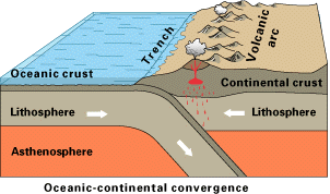 STAGE 1 - Weight of continental sediment causes subsidence of the crust
STAGE 2 - Subduction develops and an island arc forms
STAGE 3 + 4 - Compression from plate movement cause the crust to thicken and shorten through folding and thrust faulting. Fold mountain chains are formed i.e the Andes
- Mount St Helens was formed in this way, the Cascades represent the curved line of volcanoes jusr inland on the Western Seaboard
- Thicker the crust the more explosive the volcano is
 Oceanic crust is denser than continental crust so when they collide the oceanic crust is subducted. As oceanic crust descends, friction with the overlying crust builds up, generating powerful shallow-to-deep focus earthquakes that chart the descent of subducting crust. Rocks scraped off the descending plate and folding of continental crust aids fold mountain formation, whereas deep trenches form along the seaward edge of convergent boundaries. Friction generated by subduction processes generates lots of heat that enables partial melting of the crust. Consequently magmas derived from here are less dense than the mantle so it rises up through fissures until it reaches the surface. This magma is also silica enriched, therefore more viscous, hence the explosive volcanic eruptions and presence of intrusions like batholiths.
Hazards
- Very explosive volcanoes i.e Mount St Helens and Popacatepetl
Structure of Subduction Zones

- The shallower the angle of subduction, the greater the Benioff zone, therefore earthquakes can be felt over a larger area. This means it is better/safer to live in an area with a greater angle of subduction.
Characteristics of Subduction Zones
- Trenches - generally 5-8km deep, although Mariana Trench is 11km
- Belt of earthquakes with the shallowest experienced closest to the trench
- Island arcs (archipelago) form, which are usually curved i.e the Aleutian Islands
Continental vs Continental
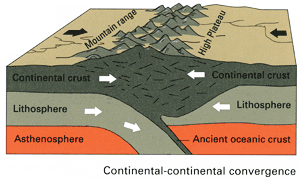 --> This is the process of mountain building as it often reffered to as ab Orogeny, and the moutains as Orogenic Belts
- We are currently in the Himalayan orogeny, where the process of continental collision is still active today
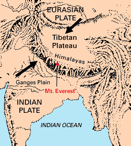 - Over the last 100ma, India has moved northwards. The Himalayan orogeny started well below the equator where an ocean existed to its north called Tethys. The subduction of the oceanic lithosphere thickened the plate to 100km and forced up the fold mountains.
Continental plates have similar densities and their buoyancy means no subduction occurs. Instead, they are associated with orogeny. Volcanics associated with earlier subduction and sediments scraped off the vanishing ocean floor are mixed up and compressed to form young fold mountain chains with deep roots in the lithosphere.
Hazards
- Plate has moved very rapidly (200mm/yr)
- Earthquakes occur often
- Crust is too thick for diapirs of magma to make it to the surface so there are no volcanoes
- Mass movement
STAGE 1 - Subduction produces partial melting and the formation of a chain of volcanoes = island arcSTAGE 2 - Build up of intrusive and extrusive igneous material, mixed with sediments, forms larger material
STAGE 3 - The island chain joins up and sediments form an accretionary wedge or prism which builds on to the fore arc area
When the plates collide, one is usually slightly denser than the other, or one is moving slightly faster then the other, so subduction occurs. Consequential subduction and its appending processes are much the same as with oceanic vs continental convergence. When volcanoes erupt islands can form and they usually form characteristically curving lines of new volcanic land (island arcs), with deep trenches. They islands can evolve over millions of years to form major landmasses, like Japan and Indonesia.
Hazards
- Volcanoes = wide cariety of typesm explosive and effusive
- Earthquakes = can be very powerful such as in Indonesia in 2004
- Tidal waves = offshore earthquakes generates waves and the steep islands often suffer inundation, the other cause is collapse of oceanic islands i.e Stromboli
Oceanic vs Continental
STAGE 1 - Weight of continental sediment causes subsidence of the crustSTAGE 2 - Subduction develops and an island arc forms
STAGE 3 + 4 - Compression from plate movement cause the crust to thicken and shorten through folding and thrust faulting. Fold mountain chains are formed i.e the Andes
- Mount St Helens was formed in this way, the Cascades represent the curved line of volcanoes jusr inland on the Western Seaboard
- Thicker the crust the more explosive the volcano is

Hazards
- Very explosive volcanoes i.e Mount St Helens and Popacatepetl
Structure of Subduction Zones

- The shallower the angle of subduction, the greater the Benioff zone, therefore earthquakes can be felt over a larger area. This means it is better/safer to live in an area with a greater angle of subduction.
Characteristics of Subduction Zones
- Trenches - generally 5-8km deep, although Mariana Trench is 11km
- Belt of earthquakes with the shallowest experienced closest to the trench
- Island arcs (archipelago) form, which are usually curved i.e the Aleutian Islands
Continental vs Continental
--> This is the process of mountain building as it often reffered to as ab Orogeny, and the moutains as Orogenic Belts- We are currently in the Himalayan orogeny, where the process of continental collision is still active today
- Over the last 100ma, India has moved northwards. The Himalayan orogeny started well below the equator where an ocean existed to its north called Tethys. The subduction of the oceanic lithosphere thickened the plate to 100km and forced up the fold mountains. Continental plates have similar densities and their buoyancy means no subduction occurs. Instead, they are associated with orogeny. Volcanics associated with earlier subduction and sediments scraped off the vanishing ocean floor are mixed up and compressed to form young fold mountain chains with deep roots in the lithosphere.
Hazards
- Plate has moved very rapidly (200mm/yr)
- Earthquakes occur often
- Crust is too thick for diapirs of magma to make it to the surface so there are no volcanoes
- Mass movement
Wilson Cycle = Opening and Closing of Oceans
Rifting controls the opening and closing of oceans. The cycle is known as the Wilson Cycle and it illustrates the balance between new crust being created by volcanic eruptions and destruction of crust at subduction zones, to maintain Earth's fixed size. This helps to explain why there are subduction zones at the edges of most continents.
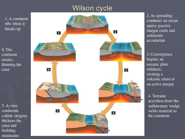 There are various stages to the Wilson Cycle and each one can be seen in operation across the world today:
- The embryonic stage, involves uplift and continental crust extention, resulting in the the formation of rift valleys (e.g. the East African Rift System).
- The young stage involves the evolution of rift valleys into spreading regions with thin strips of ocean crust between the rifted continental sections. This forms a narrow, parallel-sided sea, like the Red Sea that is opening between NE Africa and Arabia.
- The mature stage is characterised by widening of basin and its continued development into a major ocean flanked by continental shelves and with the continual production of new, hot, oceanic crust along the ridge (e.g. Atlantic Ocean).
- Eventually, this expanding system becomes unstable and, away from the ridge, the oldest oceanic lithosphere sinks back into the asthenosphere, forming an oceanic trench subduction system, such as the situation in the western Pacific Ocean. Onset of subduction at the ocean boundary marks the subduction stage (e.g. the Pacific Ocean).
- Once subduction overtakes formation of new crust at the constructive boundary, the ocean begins to 'shrink'. Island arc's collide and create young mountain ranges around the periphery of the 'shrinking' ocean. This marks the terminal stage of the cycle (e.g. the Mediterranean).
- The end stage occurs when all the oceanic crust between the continental masses has subducted, and the continents converge along a collision zone characterised by an active fold mountain belt, such as the Himalayas. The plate boundary becomes inactive, but the boundary between the two plates remains as a zone of lithospheric weakness. Therefore it has the potential to the site of a new rift and so the cycle continues.
Divergent Boundaries
 One of the plate margins is divergent (constructive) and this, in short, is when plates move away from each other, thereby generating tensional forces. As such, they are characterised by shallow-focus earthquakes and volcanism, producing volcanoes which erupt basaltic magma (unevolved) via Icelandic and Hawian style eruptions.
 - Start intra-plate
- Upwelling of magma in a plume, driven by thermo-nuclear reactions in the Gutenburg Discontinuity
- Plume rises and convection starts at the base of the lithosphere
- Convection currents rise and then diverge, creating high temperatures that cause updoming of the crust, along with tensional forces that pull it apart
- In continental crust this can produce rift valley systems such as the East African Rift Valley
- In oceanic crust, new oceanic crust is produced as oceanic ridges are created and seafloor spreading occurs
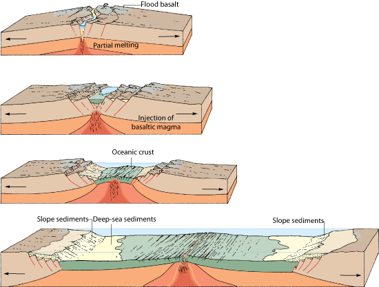
Rifting
- As convection commences the plate is thinned out by a series of extention faults
- As the plate gradually becomes thinner, volcanoes and lakes start to form in the valley
- More volcanoes continue to form until a complete ridge exists, the plate is forced apart and new basaltic oceanic crust begins to form on either side
- As the lakes connect, and the level of the land drops, the ocean floods the valley and forms an elongated sea such as the Red Sea
e.g East African Rift Valley System where eventually a new plate will form (called the Somalia Plate, and the rest of Africa, the Nubia Plate). The sea will eventually flood the valley, connecting to the Red Sea.

 e.g Where spreading occurs beneath major landmasses, heating and subsequent updoming leads to fracturing and rifting. As the sides of the rift move apart, central sections drop down to form rift valleys. The Great East African Rift Valley, indicates where the crust has begaun to pull apart, and active volcanoes such as Mount Kilimanjaro and Mount Kenya are surface evidence of igneous activity beneath. At 4000km long, up to 50km wide and 600m in depth, this feature might widen still, allowing sea inundation. To the north, two rifts have widened into the Red Sea and Gulf of Arabia. Here, the rifting has continued, with new sea floor forming between Africa on the south-western side and Arabia on the north-eastern side.
 - Other examples of past rift zones include the steep-sided valley of the River Rhine, athlough there are ancient volcanoes nearby to show how active this region once was, it is no longer subject to rifting.
Oceanic Ridges
 = Lines of submarine volcanoes that form a continuous feature throughout the world's oceans
= Centres of spreading where the youngest oceanic rocks are fund closest to the ridge
- They form the longest continuous uplifted feature, with a total combined length of over 60,000km

- Occur on divergent boundaries as a weaker zone is exposed to an increase in surface heat. Hotter crust expandsa new ridge forms and the central part of the ridge may feature a central valley if a section of crust has subsided into the magma below. This split in the crust provides a lower pressure zone where, if more lava erupts, submarine volcanoes can form. If such eruptions persist then volcanoes will develop until they reach the surface, with islands formed in this way i.e Iceland!

Transform Faults
- Spreading does not occur at the same rate along the ridge
- Transform faults offset the ridge, giving it a blocky appearance
- Distance between the fault varies and they are responsilbe for many undersea earthquakes, but due to a lack of vertical displacement, tsunami's are rarely generated
Hazards
- Frequent low grade seismicity (earthquakes below 5 on Richter Scale)
- Intense and frequent volcanism
- Ultra slow spreading = 10mm/yr i.e Atlantic, Ultra fast spreading = 100mm/yr i.e East Pacific and Galapagos
Tuesday, 7 February 2012
Back to tectonics (FINALLY!!!) - Conservative Margins and Hotspots summary
Hello everyone! I hope the exam went well for you all! We even got mention in the local newspaper - Twin Sails Bridge part of A-level exam - perhaps it would have been interesting to ask students if they would consider visiting Poole before and after studying the bridge for 2 months, then conduct a Mann Whitney U to see if there was a significant difference between number of students inclined to visit the area! Anyway I can now happily say that we will never have to study Poole/Twin Sails Bridge again!!! This means that we can finally get back to good old tectonics.....

 These margins are sometimes reffered to as passive or slip margins and occur where two plates meet and the direction of plate motion is either parallel or nearly parallel. No crust is destroyed or created, although these are areas of frequent seismic activity as the build up of friction as the plates pass each other is released by earthquakes. This boundary is not associated with volcanism.
- No subduction or abduction
- Plates try ot move laterally past each other
- Most infamous are the San Andreas Fault in the USA and the North Antolian Fault in Istanbul [both are overdue a huge earthquake!]
- No volcanism
- Generates massive earthquakes
Hotspots
- These are not boundaries, as such, but rather a surface representation of surface plumes
- Plates do not always split above mantle plumes, but as the plate moves over the magma source, it generates a chain of islands
- The oreintation of the island gives an indication of the direction of the plate movement relative to the plume
 Hawaii
 = Chain of islands, connected to the Emperor Seamount chain (submerged)
= The islands become progressively older to the northwest, indicating the plate is moving in this direction
= This was anticipated before the discovery of continental drift as the islands become shallower in gradient, more advanced vegetation succession and have deeper soils to the northwest.
Other hotspots
- Yellowstone Caldera is probably the niggest and highest risk
- Iceland is unusual being a large plume underneath a divergent boundary
This mantle plume theory is stil hotly debated and poorly understood - it is one of the few remaining mysteries of tectonic theory, which is otherwise now widely accepted.
Divergent and convergent boundary notes are on the way!
Correct me if I am wrong but I think before Christmas I only got as far as outlining the basics of this module, so I have quite a bit to catch up on! I have already lost count of the number of you who have asked very nicely for some case study orientated posts so I will try and find the time over the coming weeks to go over case studies whilst also finding the time to write about Iceland (apologises but I am starting to get a little excited and a condition of me going was that I don't talk about it at home!). For now though I will leave you with a few brief notes on conservative boundaries and hotspots (sorry if the image quality is a bit poor but I gave up trying to find good diagrams online so just photographed my notes) - I am hoping to cover all the volcano stuff this week so I can focus on earthquakes over half term so be warned that a lot of posts may appear over the coming days!
Conservative Margins
Conservative Margins
 These margins are sometimes reffered to as passive or slip margins and occur where two plates meet and the direction of plate motion is either parallel or nearly parallel. No crust is destroyed or created, although these are areas of frequent seismic activity as the build up of friction as the plates pass each other is released by earthquakes. This boundary is not associated with volcanism.
 - No subduction or abduction
- Plates try ot move laterally past each other
- Most infamous are the San Andreas Fault in the USA and the North Antolian Fault in Istanbul [both are overdue a huge earthquake!]
- No volcanism
- Generates massive earthquakes
Hotspots
- These are not boundaries, as such, but rather a surface representation of surface plumes
- Plates do not always split above mantle plumes, but as the plate moves over the magma source, it generates a chain of islands
- The oreintation of the island gives an indication of the direction of the plate movement relative to the plume
 = Chain of islands, connected to the Emperor Seamount chain (submerged)
= The islands become progressively older to the northwest, indicating the plate is moving in this direction
= This was anticipated before the discovery of continental drift as the islands become shallower in gradient, more advanced vegetation succession and have deeper soils to the northwest.
Other hotspots
- Yellowstone Caldera is probably the niggest and highest risk
- Iceland is unusual being a large plume underneath a divergent boundary
This mantle plume theory is stil hotly debated and poorly understood - it is one of the few remaining mysteries of tectonic theory, which is otherwise now widely accepted.
Divergent and convergent boundary notes are on the way!
Wednesday, 1 February 2012
Last minute Poole revision - What is the issue?
I had quite a few people approach me today to ask me if I could write up a post on a few last minute things. First up was fieldwork but Millie has very kindly covered this and is currently running one of her invaluable live online workshop for any last minute questions so instead I am going to focus on the other areas people requested - some facts and statistics you could include to enhance your answers tomorrow and a brief summary of the synoptic links that can be made.....This will greatly be in note form, so apologises for the poor use of language and just general disorganisation!
It has taken me a while to realise (and accept!) that this is an Issues Evaluation exam not a research exam so we need to demonstrate tomorrow how well we can all 'think like Geographers', not how much information we have absorbed about Poole! I suspect that most of you will be reciting this in your sleep by now but the issue in this topic is:
It has taken me a while to realise (and accept!) that this is an Issues Evaluation exam not a research exam so we need to demonstrate tomorrow how well we can all 'think like Geographers', not how much information we have absorbed about Poole! I suspect that most of you will be reciting this in your sleep by now but the issue in this topic is:
People are concerned about the environmental damage that may occur because of the regeneration of the area around Holes Bay which has arisen because of changes in industry and population growth but might be resolved by following the advice of the appropriate assessment.
Holes Bay is an area of international importance due to its ornithological interest, which has resulted in international protection for the area via Ramsar status, SSSI's and SPA's, and the worry is that regeneration could detrimentally affect this delicate area. By abiding by the appropriate assessment the environmental impacts should be minimised. However, regeneration is needed in Poole as population has rapidly expanded and the structure changed, meaning different needs have to be accommodated for. Also, due to geographical barriers, urban sprawl cannot occur so regeneration of brownfield sites is the only viable option. Changes in population have been accompanied by changes in industry and consequential shifts in employment, resulting in more people commuting into Poole or travelling from Poole to find employment, both of which have increased congestion.
Just a few noteworthy facts:
- Poole's population has expanded from c.19,000 in 1900 to c.141,000 today
- The population is expected to increase by a further 8.7% (to c.151,481) by 2016
- 20.3% of the population is 65+ which is higher than the UK average (think ageing population)
- 24.8% of population are between the ages of 45-64 which is above UK average (link to umemployment issues)
- 78.7% of Poole's workforce are employed in services
- Sandbanks is the 4th most expensive place to live in the world
- In 2006, Poole was ranked the most unaffordable town to live in in the UK
- Poole made £158 million from tourism in 2002 alone
- Existing bridge built in 1927 to replace the Iron Swing bridge built in 1885. This bridge replaced the Wooden Toll bridge (built in 1834) which had too steep a gradient for horses
- Twin Sails Bridge has cost £37 million plus and additional £2 million for the road network
- Economic impact of £400 million
- Twin Sails Bridge consists 10.8m wide carriageway providing two taffic lanes, 1.5m wide cycleways along both edges of carriageway, two 2.5m pedestrian footpaths = total width of 19m
- Leaves pivoted through an 88 degree angle by two hydraulic rams
Population Synoptic Link: This is the most obvious one! The AS population module links very well with regards to how our transition through the Demographic Transition Model has influenced urban structure and form and caused it to change accordingly. Migration also is related as whilst the population has grown steadily since the 1960s, inward migration to counteract suburbanisation is responsible for most of the growth , with this occuring as a consequence of retirement. This provides a great link to ageing populations! The UK has an ageing population and many elderly people choose to retire along the coast and in the countryside, for obvious reasons, and whilst some have the disposable incomes required to live in Sandbanks, most don't and so affordable housing is needed. This could be taken one step further by mentioning social changes that have occured, like an increase in divorce and amount of people living alone etc which means that more houses are needed.
Development and Globalisation Synoptic Link: Taken mention of the movement through the DTM one step further, mention could be made to the Rostow Model of Development as demographic constraints are being placed on future economic and social development in Poole so for them to continue to develop they need to dilute the demographic constraints by providing much need housing and services. Unemployment is an issue in Poole and the Twin Sails Bridge is designed to catalyse further regeneration by opening up 26 hectares of brownfield, with the hope that businesses will invest. If and when they do, it will kickstart the model of cumulative causation, provide much needed employment and most likely lead to further regeneration. With good road and rail links to London and good sea access to Europe from a naturally protected harbour, and with reduced congestion (hopefully!) and an available workforce it is likely to seem like an attractive place for TNCs who want to settle inside the EU to avoid trading tariffs.
Energy Synoptic Link: Sustainabilty, with regards to converting it from a concept to reality - due to the environmental considerations the regeneration needs to be sustainable. Measures to ensure this is so have included the planned use of solar panels on roofs to heat water to help regeneration scheme meet the Code for Sustainable Homes Level 4. The new bridge provides better facilities for cyclists with the hope that car usage will be reduced, whilst car sharing schemes have been encouraged in the area. On the other hand you could argue that regeneration has increased use of fossil fuels, thereby increasing pollution and consequential environmental impacts.
Climate Synoptic Link: First one would be climate change; currently the construction work is increasing amount of anthropogenic forcing in the short term. However green wedges improve air flow and quality. Increasing urban development will add to the urban heat island effect which increases urban temperatures. Questions over whether area is suitable for regeneration as vulnerale to sea level rise (risk increased by isostatic readjustment), more storms in an area already suspectible area that experiences full force of prevailing winds, more flooding etc.
Rivers Synoptic Link: Poole is low lying and vulnerable to flooding, with many of the areas lying in flood zones. Some areas are already protected but regeneration is likely to be accompanied by further protection. Developing areas like Hamworthy Gate will increase the amount of impermeable surfaces, altering hydrology, most notably increasing runoff and consequently the flood risk. Wetlands are also very vulnerable to excess runoff.
Coasts Synoptic Link: This kind of overlaps with rivers and climate but the location of Poole and its geology leaves it vulnerable to erosion. You also have the spit there which provides natural protection for this natural harbour but needs management to maintain stability. This is likely to happen due to economic value of the area. Isostatic readjustment and eustatic sea level rise pose a huge threat to this low lying coast line so questions are raised over whether or not we should redevelop it. Touristic value of this area which could be classed as a honeypot site.
You also have all the links to current affairs such as economic climate, olympic games etc...
So there are plenty more synpotic links and this covers all of the modules we have/do study.... apart from volcanoes. A few of you did remark that I would never be able to link this to volcanoes so here is my attempt (just for a bit of fun!)....
If Katla was to erupt and close European airspace for three years then Europe would have a greater reliance on using ports to sustain trade. Therefore Poole would see an increase in use of the port as it provides a good link to Europe and London. Also if people cannot travel abroad to go on holiday then honeypot sites such as Poole would likely seen an influx of tourists, with people having to opt to holdiays within the UK. The Twin Sails Bridge would help Poole cope with increased traffic flows and the regeneration would provide the required facilities to support this move, such as hotels and restrauants etc.
Good luck to everyone in the exam tomorrow!!! Just remember, we have to THINK LIKE GEOGRAPHERS!
Subscribe to:
Posts (Atom)