Showing posts with label Earthquakes. Show all posts

Monday, 28 November 2011

Plate Tectonics - the basics...

Seeing as we have just started vulcanicity, I thought it would be a good time for me to re-cap on what we should have learnt so far (we have covered quite a lot of new stuff, especially for non-Geologists such as myself, so this will probably have to be written over a series of posts)......

First up, we need to have a basic understanding of the evidence that exists which supports the theory of plate tectonics. As simply as it can be put, we have older evidence and newer evidence.

Older Evidence:
- Biology - same fossil formations found in different parts of the world
- Geology - rocks of same afe and type and displaying the same formations found across the globe. Similar glacial deposits are found in Antarctica, South America and India, now many thousands of kilometres apart; striations showing the same orientation when the continents are reunited, are found in Brazil and West Africa.
- Climate - fossils of plants that live in tropical conditions found in Antarctica, with it incredibly unlikely that tropical climatic conditions ever existed in Antarctica's current location. PLaces apart across the globe contain coal deposits of similar age that were formed in tropical conditions; they are no longer in tropical climatic belts therefore must have drifted apart since the Carboniferous period.

New Evidence:
- Discovery of the Mid-Atlantic Ridge (1948)
- Paleomagnetism and the reversal of the Earths magnetic field (1950s)
- Seafloor spreading and then carbon dating of the seafloor rocks (1960s)
After passing the Curie Point, iron ions within the lava will
align to magnetic north......
.....This means that as the seafloor has spread, and magnetic reversal has occured in
the past, stripes are visible on the seafloor, preserving a record of the Earth's polarity at the time
of the lava cooling. This has helped to support the idea of seafloor spreading as the youngest
 rock is located nearest to the ridge.

Hopefully, this timeline summarises the key dates and discoveries we need to know about!


Structure of the Earth:

1. Crust :- it is the upper layer which is solid and is divided into 2 types;
       - Oceanic crust = mainly basaltic in nature and around 6-10km thick. It is more dense and younger than continental curst
       - Continental crust = composed of a wide variety of igneous, metamorphic and sedimentary rock. Can be as much as 70km thick.
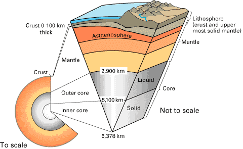
2. Moho Discontinuity :- boundary between the crust and the mantle. Average depth of 8km below oceanic crust and 32 km below continental crust. Has density similar tp an olivine-rich rock such as peridotite and so is less dense than the mantle; as such seismic waves accelerate in this region.

3. Mantle :- below the crust. Upper part is solid and is part of the lithosphere. Below this is the asthenosphere which is partly molten and can flow, whilst the rest of the mantle is liquid.
       - Lithosphere = consists of the outer solid part of the Earth, which includse the crust and rigid upper mantle. The lithosphere is about 100km thick, although thickness is age dependent (oldest=thickest). Lithosphere below the crust is brittle enough at some locations to produce earthquakes by faulting, such as within subducted oceanic plate.
      - Asthenosphere = ductile part of the Earth just below the lithosphere, including the lower mantle. It is about 180mk thick. Relatively slow seismic movements compared to the lithosphere.

4. Gutenburg Discontinuity :- boundary between the outer core and the mantle. Where thermal nuclear reactions occur that start convection cells off in the mantle, sending plutons of hot magma upwards. Located at a depth of about 2,800km and marks a sudden increase in density.

5. Outer Core :- liquid iron-nickel alloy, temperatures of over 6000C.

6. Inner Core : - Solid iron-nickel alloy. Even though temperature is higher than the outer core, the pressure produced by overlying weight is strong enough to prevent the liquid state.

How do we know this? Well, studies of earthquake waves, with regards to the velocities and paths of such waves,  depends on what excatly it is they are passing through. P waves can travel through anything but S waves can only pass through solids; so by studying these waves it has been possible for scientists to determine the physical composition of the Earth's interior.
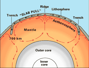
Convection Currents = Driving Force

- Occur in the mantle, very slow convection currents flow in the asthenosphere
- Provide horizontal forces on the plates of the lithosphere, with high temperatures causing updoming and tensional forces pulling the crust apart
- Start in the Gutenburg Discontinuity where thermal nuclear reactions send a pluton upwards

Boundary Types

The Earth's lithosphere is split up into 7 major plates, and around 14 minor ones, with some plates composed of both oceanic and continental crust. Between these plates are boundaries/margins, and there are three main types.......
----- I am going to do a seperate post for each boundary type but, in short:-

- Divergent (constructive) = Plates move away from each other, generating tensional forces. Consequently, characterised by shallow-focus earthquakes and volcanoes producing basaltic magma, forming new oceanic crust. Produces oceanic ridges and rift valleys.

- Convergent (destructive) = Plates move towards one another, generating compressional environments, therefore are characterised by deformation, volcanism, mountain building, seismicity and mineral deposits. Three possible types:-
                                                                - Oceanic vs Oceanic
                                                                - Oceanic vs Continental
                                                                - Continental vs Continental
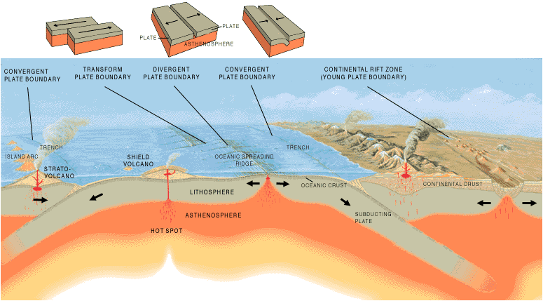
- Conservative = Plates move laterally past each other, or in the same direction at different speeds. Produces a lot of shear stress as lithosphere is neither destroyed or created. No volcanic activity but lots of shallow-focus earthquakes, intensely shattered rock and characterised by production of faults parallel to plate movement.

Wednesday, 24 August 2011

Earthquake hits East Coast of America.......Could it have been caused by fracking???

Yesterday, a magnitude 5.8 earthquake hit Virginia, with tremors being felt in Washington D.C. and New York City. Although in comparison to the earthquake that hit Japan this year it sounds rather small, for this region, it was quite large and is currently being classed as a 'rare but significant event for the region'. Earthquakes rarely strike this region, primarily due to its distance from any tectonic plate boundaries (closest being about several hundred miles away in the Altantic), and when they do occur they are generally less severe - although the risk is not insignificant. In contrast, California experiences more severe and frequent earthquakes as the San Andreas fault runs practically straight through it.

(I have ratherly cheekly copied the video that Millie posted on the FB page)

Despite this being the largest earthquake to hit this area since the 31st May 1897, and the fact that it was above 5.5 in magnitude (kind of like the threshold above which it becomes a concern in relation to structural damage), it is believed that the impacts will be relatively minor. At 5.8, it is just below the magnitude required for liquefaction to occur, something that often causes significant damage, and structurally, the earthquake is only believed to have caused a few cracks in buildings and a few collapsed chimneys etc. The two nuclear power plants in the region where successfully shutdown.

So, what caused this earthquake???

Well, some scientists believe that it could be caused by the release of stress from a small thrust fault in the region. The impact of the earthquake was then increased by the fact that, because it occured far away from major plate boundaries, the continental rock is much older (bedrock beneath Virginia is believed to have formed when the continents collided to form a supercontinent about 500-300 million years ago) and denser, so more like a solid sheet of bedrock, and so the seismic waves were permitted to travel further.

Another suggestion is that fracking could have caused the earthquake. Now I don't personally know that much about fracking but I will try and explain why some believe that a recent rise in fracking could have provoked the earthquake. Correct me if I am wrong but I believe that fracking, or hydraulic fracturing, is the man-made splintering of underground rocks to speed up the exploitation of natural resources and, since its inception in 2004, has become increasing popular as it can allow for the recovery of oil and gas supplies. Due to the impact that fracking can have on the geological make-up of the Earth many are starting to insinuate that it could cause earthquakes. In locations were fracking occurs, the waste salt water produced is injected back into the earth (after the fractures have been created) and some estimate that, in each well, 3 million gallons of waste is injected.  With reference to the East of USA, earthquakes, as previously mentioned are rare, but the surrounding area has experienced 8 minor tremors last year alone - an area that has also seen an increase in fracking operations over the past few years.

This is not the only earthquake that some are suggesting has been caused by fracking. The USGS have said that "Earthquakes induced by himan activity have been documented in a few locations in the United States, Japan and Canada" with "The cause the injection of fluids into deep wells for waste disposal and secondary recovery of oil and the use of reservoirs for water supplies". Geologists have more recently blamed fracking for the 20 tremors witnessed in the state of Arkansas in one day; also similar size earthquakes have been experienced in Texas, New York and Oklohoma, all of which are not normally likely locations for epicentres but have experienced a significant increase in fracking over the last few years. What is quite interesting is that the multi-stage fracking being held responsible (it drills several miles deep into the Earth), has only recently, over the past 2 years, become prevalent in the above mentioned areas, all of which have seen a rise in tremors, and have since banned fracking - an action that seems to have been followed by a reduction in size and frequency of tremors. Since this, more states are now reviewing their current legislation on fracking.

So, what do you think? Is it possible that these earthquakes are really being caused by fracking and if so, along with some of its other detrimental impacts, is this reason to prevent it from being utilised in the future? Do you actually think that we would ever place a global ban on it, due to our increasing hunger for energy and dwindling supplies of oil? On the other hand, do you feel that a release of stress from the thrust boundary is a more logical explanation? My knowledge on this is a bit limited so if anyone knows are more I would love to hear about it! Let me know what you think.........

Whilst on the topic of earthquakes, I read this other blog that is related to geography (kind of more human geography I suppose and is one that Millie suggested) written by this person from Sheffield University, and he produces these really interesting maps as a graphical way of presenting data (they are a bit different to maps I have ever seen before!). He wrote a post yesterday on the earthquake, although it focuses a bit more generally just on earthquakes as a whole and the impacts, which is definetly worth a read. Magnitude 5.9: Earthquakes revisited I do try and keep some sort of balance between my human and physical geography posts but if you are ever looking for something human related to read, his posts are often quite interesting - it is included on my (extremely short!) blogs I read list at the bottom of the blog so keep an eye out for it in the future! If you ever come across anyother earth science related blogs you think are worth reading just let me know - I am always looking for different things to read!

Sunday, 27 March 2011

Japan Earthquake: A Horizon Special with Iain Stewart

I have literally just watched this and it is without a doubt one of the best documentaries/TV programmes that I have watched on the Japanese Earthquake, if not the best. Not only does it cover the impacts of the earthquake and tsunami by presenting the shocking images from during and after these disasters hit but also goes on to explain why the earthquake was so big and why the tsunami was so destructive. The problems being experienced with nuclear power are explained whilst maps are used to represent where the worlds nuclear power plants are located in relation to the tectonic plant boundaries.The issues surrounding earthquake predictions are also presented and the documentary explains that, although at present we cannot predict earthquakes, we are getting better are pin pointing areas that are suseptible to large and destructive earthquakes. On top of all of this, the likelyhood of Tokyo experiencing the much dreaded 'Big One', after recent events, is explored.

This is definetly well worth watching and I would highly recommend it! You can catch it on BBC iplayer http://www.bbc.co.uk/iplayer/episode/b0101nq2/Horizon_Japan_Earthquake_A_Horizon_Special_with_Iain_Stewart/