Showing posts with label Random bits of Geography. Show all posts

Tuesday, 31 May 2011

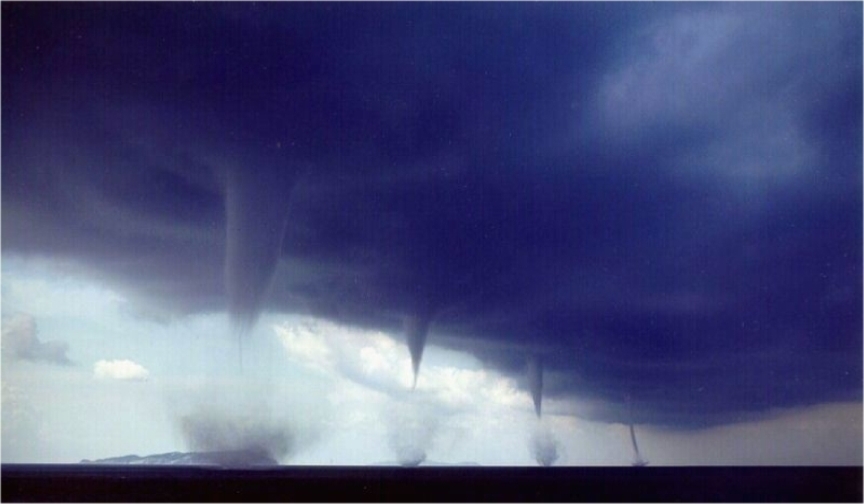
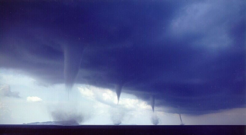
Waterspout off the southeast coast of Australia

When I first started writing this blog, I didn't really know how to write it and one of the suggestions made by one of the Geography Teachers was to watch the news and then write about that news story/footage in more detail. So, I thought I would give it a try..............
This footage was shot yesterday and was shown live on an Australian news channel. According to the reporter the scientific reason for the occurence of a waterspout is when there is a "bit of wind going around in circle" but I think there is slightly more to it than that.......

So, what excatly is a waterspout? Waterspouts are intense vortex funnels, which can sometimes be destructive, with a small width, that occur over water. Like dust devils and tornadoes, waterspouts are convective vortices whose circulations are driven by convection forming rising shafts of air. Proper waterspouts form over the water and will dissipate almost immediately upon touching any landmass. You can also get Tornadic waterspouts which are tornadoes which have been produced by severe thunderstorms and touch down onto or cross a body of water.


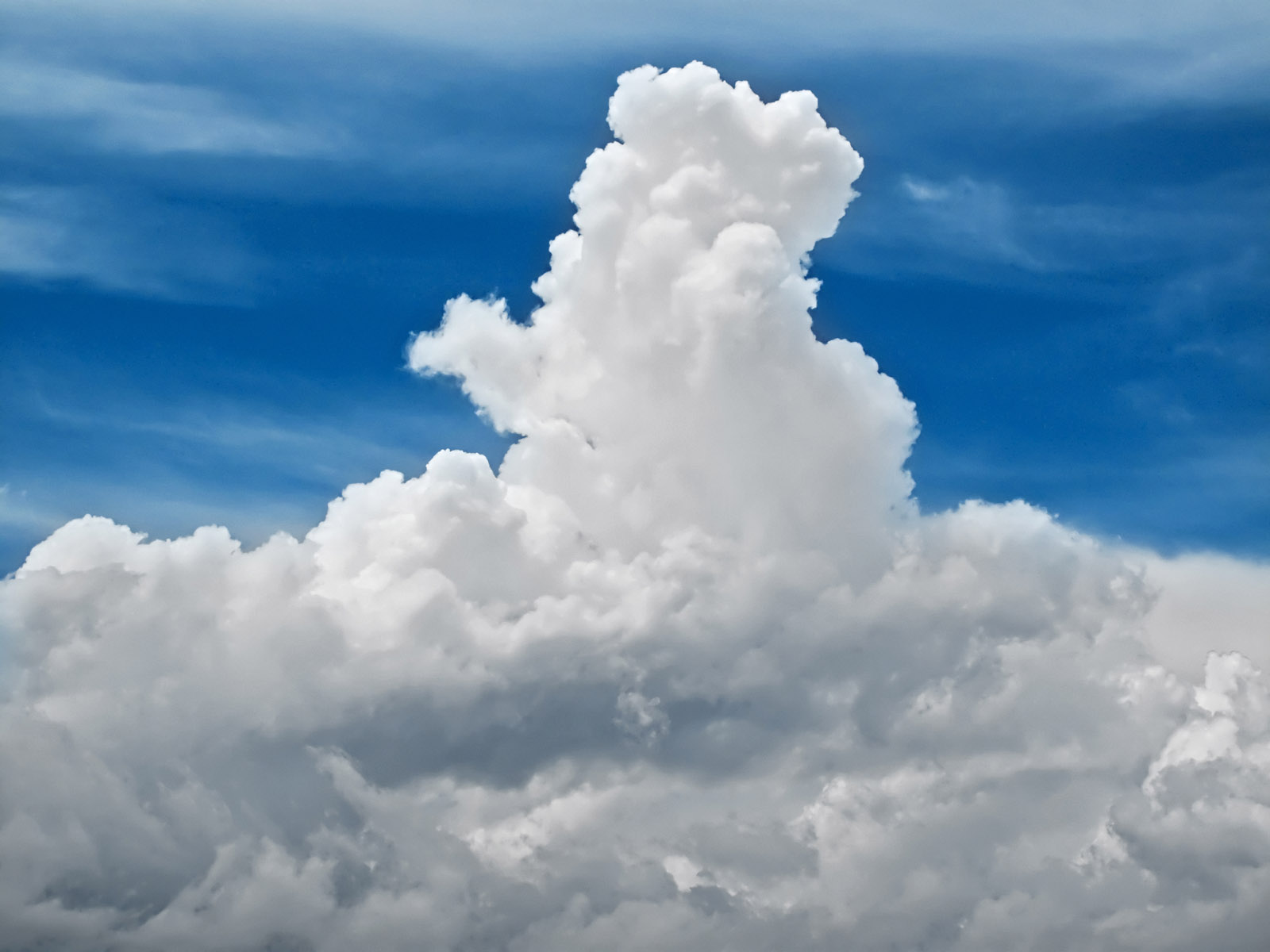
This is a cumulus congestus cloud. They are heap clouds which
 have a large vertical and horizontal extent which are often said to look
 like a cauliflower as they have a flat bottom with a rounded but distinct top.
Waterspouts develop beneath the lines of rapidly growing, shallow cumulus congestus clouds (normally around 3000-4000m deep and 600m above the surface).  Most form in very warm subtropical waters, although some can form in large lakes and along the coastline. The vital condition for their formation is a much warmer surface water temperature then the air above. Therefore they form most during summer in subtropical waters or during late summer in lakes and along the northern coastline. A waterspout develops when a shaft of warm air forms at the water surface and begins to rise rapidly, which makes it spin. The waterspout funnel then begins to develop at the surface of the water and then builds up towards the sky. It often looks as if the waterspouts are sucking water up, from the water surface, but it is actually the condensing of water vapour in the rotating vortex and this makes the waterspouts visible. Waterspouts can spin clockwise or anti-clockwise and at the base of the funnel, the water is stirred into mushroom shaped water sprays.

It is easiest to understand them by looking at a diagram:

1. Water temperatures have to be around 26/27 degrees Celcius
2. Rapidly rising warm air forms lines of towering cumulus clouds
3. Rotation, either clockwise or anit-clockwise, begins as air converges on the column of rising air
4. A dark spot, which is normally only visible from above, appears on the ater surface. This is the first sign of a waterspout developing
5. Surface winds of around 50mph can produce sea spray at the base of the waterspout

 Compared to tornadoes, waterspouts are less destructive as they are less well defined. They can pose a threat to infrastucture just off the shoreline or boats, as they have the power to overturn them, but, because they are slow moving and highly visible, boats are normally able to steer away from them and so any possible danger.


Friday, 27 May 2011

The race for a million year old ice sample

Around every 100,000 years the Earth enters an Ice Age but it hasn't always been this way...... Up until about a million years ago the Earth swung between glacial and interglacial periods a lot faster, with this switch occuring every 40,000 years. However, no one knows why the time taken for Ice Age's to occur slowed and this is why scientists are so eager to find a million year old ice sample.


Axial Precession

At present, the switch between glacial and interglacial periods is believed to be influenced by three cyclical changes to the Earth's motion known as the Milankovitch Cycles, which were named after the Serbian astronomer who is credited with discovering their magnitude. The first of these cycles is called Precession and relates to the wobble of the Earth as it spins on its axis provoked by the gravitional interaction between the Sun, Moon and Earth. Precession occurs on a 26,000 year cylce and there are two forms - axial and apsidal precession. Axial precession is linked with the tilt of the axis in relation to the fixed place of the stars Vega and the North Star as the Earth wobbles from pointing to the North Star to pointing at Vega. If the axis tilts towards Vega then then the winter solstice in the Northern Hemisphere will coincide with the aphelion (point at which the Earth is furthest away from the Sun) and the summer solstice with perihelion (the point at which the Earth is closest to the Sun) thereby creating the greatest seasonal differences. When this occurs, the Southern Hemisphere experiences warmer winters and cooler summers and so a smaller seasonal difference. However, when the tilt of the Earth allows for the aphelion and perihelion to, respectively, occur near the autumn and spring equinoxes, the seasonal contrasts experienced in the Northern and Southern Hemisphere become similar.  At present, the perihelion is closer to the Northern Hemisphere's winter solstice therefore meaning a small seasonal difference in the Northern Hemisphere. Apsidal precession occurs when the Earth's orbit, as a result of the influences of the Moon, Jupiter and Saturn, starts to precess in space. This movement is known as the precession of the equinoxes and it effects the intensity of the seasons. So, in summary, Precession does not effect the amount of solar energy recieved by the Earth but the way it is distributed between the two hemispheres, therefore altering the seasonal differences experienced.

Apsidal Precession
 
Obliquity
The second cycle is the tilt of the Earth's axis which, I think, is normally known as Obliquity or the Angle of Inclination. Currently, the axis lies at a 23.4 degree angle and over a 41,000 year period this varies between 22 degrees and 24.5 degrees, thereby altering the latitundinal distribution of solar energy. This fluctuation in the angle of incidence causes changes in the intensity of the seasons experienced. As the angle of incidence increases, during summer, areas at high latitudes experience more solar energy whilst in the winter they experience a decrease in insolation (insolation is a measure of solar radiation energy recieved on a given surface area in a given time). This allows for permanent snow fields to form in the Northern Hemisphere.  In relation to low latitudes, changes in Obliquity have little effect as the strength decreases the closer you get to the equator. Therefore, changes in Obliquity alter the strength of the latitudinal temperature gradient. When the axial tilt is lower the Sun's solar radiation is more evenly distributed between the seasons but the difference in radiation recieved between the equator and polar regions is greater. A smaller degree of axial tilt would provoke the formation of ice sheets because warmer winters would result in more warm air, which has the potential to hold more moisture and so produce more snowfall. Ontop of this, milder summers would mean that less of the ice formed over winter would melt.


Circular orbit
 

Ellipictal orbit 
 
The third, and final, cycle is known as Eccentricity which is the shape of the Earth's orbit around the Sun. The changes in Eccentricity occur due to the gravitional influences of Jupiter and Saturn and the shape of the Earth's orbit around the sun changes from being ellipictal (eccentricity of 0.0607) to less ellipictal/more circular (eccentricity of 0.0005) on a cycle of around 100,000 years. This is of great importance to climate and glaciation as it alters the distance between the Earth and the Sun, thereby changing the distance that the Sun's radiation has to travel before reaching the Earth. This subsequently reduces or increases the amount of radiation recieved on the Earth in different seasons as this variation has a direct impact on the amount of solar energy recieved at perihelion in constrast to aphelion. Currently the Earth's Eccentricity is 0.016 which results in a 6.4% increase in the level of insolation recieved in January in comparison to July. This increase has been provoked by the 3% difference in the distance between perihelion and aphelion. When the Eccentricity is higher (so a more ellipictal orbit) the difference between the solar energy recieved at perihelion can be anything between 20% to 30% greater than that recieved at aphelion. The variations in Eccentricity also impacts on the length of the seasons and, at present, in the Northern Hemisphere, summer is 4.66 days longer than winter and spring is 2.9 days longer than autumn. Overall, Eccentricity influences the amount of solar radiation that reaches the Earth and so the fluctuations in Eccentricity play a key role in determining climate and the occurance of glaciation. 

So, a short summary about Milankovitch cycles......  basically the changes in Procession, Obliquity and Eccentricity alter the intensity and distribution of solar radiation hitting the Earth which then affects the climate, with particular reference to the extent of glaciation. Milankovitch used these variations to develop a mathematical model which linked insolation to the corresponding surface temperatures and from this model he came to the conclusion that variations in insolation at high latitudes were responsible for the increase and decrease in the size of the ice caps at the poles. One crucial thing that I have yet to mention is the importance of landmass when talking about the Milankovitch cycles as it helps to explain why fluctuations in Precession, Obliquity and Eccentricity are harder to locate in older records. The Northern Hemisphere is known as a Milankovitch sensitive region and, as mentioned above, the effects of alterations in the three cycles decreases as you get closer to the equator and lower latitudes - which don't lie in Milankovitch sensitive latitudes. Therefore, when Pangea existed, which was centred around the equator, the cycles did not have such a prominent effect............. and so the question is, what did? 

This is perhaps the most puzzling question surrounding the shift to a slower pace, by the Earth, around a million years ago as records suggest that their was no obvious change to any of the three cycles and this is yet another reason as to why finding a million year old ice sample is so important. Understanding this shift would enable us to understand why we have the climate we do today and, perhaps, even help us make better predictions for the future climate. One of the most common possible explanations for this shift, at present, is the idea of the slow decline in concentration of the carbon dioxide in the atmosphere that is believed to have started to occur around 3 million years ago. This would have reduced the greenhouse effect and, possibly, cooled the Earth to the extent that the tilt of the Earth towards the Sun, every 41,000 years, was no longer able to provide sufficient heat to melt the glaciers that formed in between.  Confirmation of this is required though and is dependent on the finding of a direct record of the ancient atmosphere. This can only be uncovered from the analysis of the air that became trapped in tiny bubbles within ice as the snow it formed fell to Earth. In 2005, the European Consortium for Ice Coring in Antarctica discovered, to date, the oldest ice core which has stretched our records of the ancient atmosphere back 800,000 years - however, this is short of the crucial time period in which the key transition from a 40,000 year ice age pulse to an 100,000 year one occured.  And so, the race is on to find this crucial million year old ice core........

The EPICA have been joined in the race by an Australian Antarctic Division, an American contigent and a research team from the Chinese Arctic and Antarctic Administration. The Chinese have already secured a location in east Antarctica but have been set back by the discovery that the ice sheets in this chosen location are growing from the bottom up which means that the ancient ice has most likely melted or been replaced already. The Australians are close to securing a site in the Aurora basin, also in east Antarctica, which is believed to be home to the thickest ice in Antarctica, however research needs to be done to ensure that they too don't experience the same set back as the Chinese. Despite this, climatologists remain optmistic that a million year old ice core will be found eventually as it is one of those things that is going to take time. Current drilling methods, which are very similar to those used in the oil industry, mean that to reach this million year old ice core, which is hoped to lie at around 3000 metres deep, will take three summer seasons due to the remote locations of potential sites, but advances in technology mean that this process could be sped up.

This race for the million year old ice core is clearly no where near finishing and, despite the competition that exists between the four teams, the international collaboration that exists will hopefully allow for this increasingly important clue, that will be provided by this crucial ice core, to be uncovered and consequently provide information as to why the climate we presently experience exists and perhaps even how and why, due to physical influences, it could change in the future.

Monday, 11 April 2011

Geysers

I am aware that most of my posts over recent weeks have just been lots of writing and I am conscious that over the next week, as I finish some posts I am working on and move on to type up some revision notes, that there will be a lot more to come. So, I thought (and I welcomed this break) that I would write a short post with a few pictures to help me describe how geysers form - yes I know its a bit random but I fancied a break from meanders, the DTM and wind turbines!

What is a geyser?
A geyser is a fountain of steam and water that erupts from the ground under pressure from a reservoir of superheated water below the surface.

How are they formed?
Silica seems to play an important role in the formation of geysers as, as the silica rich superheated water (the groundwater is so hot due to the fact that they form in areas of volcanic rock) makes its way up towards the surface the silica is slowly deposited on the walls of the channels/tunnels. This creates a water tight plumbing system which, as the water travels through it, constricts the flow close to the surface. This increases the pressure and allows the temperature of the water to remain above its boiling point in a reservior above the surface. As the temperature continues to increase, pockets of water at the bottom turn to high pressured steam which forces its way out of the constricted opening. This provokes a sudden decline in pressure which instantly causes the superheated water to boil, causing a jet of steam and water to explode out of the ground. Geysers sometimes erupt from within pools but, if they don't, a concial structure created by silica deposits (known as geyserite - I think???) gradually develops.


Where can they be found?
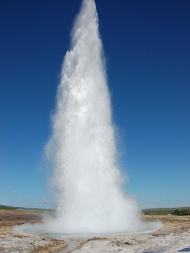
The majority of the time, geysers form in groups known as geyser fields in areas where the underground heat and volcanic rock formations produce the required conditions. There are estimated to be around 1000 geysers across the globe and Yellowstone Park contains about half of them, including Old Faithful which erupts every 90 minutes, shooting thousands of gallons of water around 185ft into the air. Yellowstone is also home to the largest geyser in the world (Steamboat - see image below) which, although rather infrequently, shoots hot water up to 400ft (120metres) into the air! Geysers can found in Chile, New Zealand, Alaska and Iceland too, amongst a few other countries. The time between eruptions varies from geyser to geyser and can be anything from a few minutes to several years.

Sunday, 3 April 2011

Is there such a thing as a man-made natural disaster?

Do man-made natural disasters exist? Well I realise that this statement sounds rather contradictory but is it possible that human activity can provoke events that we class as natural disasters, such as a volcanic eruption or an earthquake, for example.

From a discussion I had with Millie, it seems that there is a rather interesting history behind the Lusi volcano in East Java and a lot of controversy surrounding what caused it to erupt and this could possibly be an example of a man-made natural disaster (if such a thing exists). Many geologists blame the unregulated and careless drilling performed by a natural gas company whilst others, the natural gas company included, believe that an earthquake provoked Lusi to start spewing large volumes of mud. Geologist Richard Davies, who was one of the head Geologists at a meeting held in South Africa to determine the cause of the eruption, strongly believes that the evidence suggests that it was the unregulated drilling of Lapindo Brantas. Before I start to try and explain why geologists believe the drilling provoked the eruption, I must point out that I don't study Geology and so I am going to apologise in advance to any Geology students out there who may read this as I am only going to explain the very basics and just hope that I don't get out of my depth - feel free to correct me! Drillers exploring for natural gas bored 1091 metres down through the stratas of sandstone and mudstone and then in an attempt to strength the hole they inserted a steel casing. However, as they continued to drill deeper, they failed to insert more steel casing, thereby weakening the hole. Water and the natural gas they were searching for started to fill the hole and build up pressure which eventually fractured the unprotected rock strata. Hot, pressurised water was then released from the Kujung limestone aquifer. The geothermal energy from the near by arc of volcanoes (the closest one, Arjuno, being 15km away) is believed to explain why the water was so hot. This hot, pressurised water, accompanied by the gas, raced upwards and mixed with the mudstone which resulted in masses of it being liquified. Davies believes that it was the penetration of the already pressurised limestone that caused the entrainment of the liquified mudstone by the hot water which then resulted in it surging through the layers of sandstone and mudstone, until it broke through the surface - and I think we all kind of know what happened next!

Overall, Davies' report concluded that the eruption was triggered by the drilling and the attempt to control a huge influx of water and natural gas that fractured several sections of the borehole. On the other hand, Lapindo Brantas and their senior drilling advisor, who used the same evidence as Davies did for his study, claims that the pressure levels in the well were within the acceptable limits. This is the total opposite to the analysis of the same data that Davies published as he said that the build up of pressure caused the formation of fractures which propagated from the borehole to the surface around 150m away, thus resulting in the eruption. A geologist for the drilling company denies that the levels of pressure in the well would have caused these fractures and instead claims that the erutpion was caused by an earthquake that occured a few days before Lusi starting spewing hot mud. Dr Mazzini claims that the fracture was triggered by an earthquake, of magnitude 6.3, that occured two days earlier and some 280km away. This was contradicted by an independent geologist from Australia, who specialises in geological pressure and rock mechanics, who said that the earthquake "was at least an order of magnitude too small" and that the force felt at the Lusi site would have been "very small and comparable to the effect of a heavy truck passing overhead". Davies also said that although seismic activity can provoke mud volcanoes, both of which are common in East Java, that he was 99% certain that Lapindo's drilling caused the mudflow.

From all of this, I think it is clear to see that the drilling company has a very different view of how the eruption was provoked to that of many of the geologists that investigated the circumstances. However, at the meeting held in South Africa, which was designed to investigate the cause and what was to blame, 42 out of the 74 independent geologists/scientists that attended were convinced that drilling triggered the eruption. In comparision, only three voted that the eruption was triggered by the earthquake. So, what has happened since this Lusi first starting erupting, way back in 2006. Well, initially, Lapindo were ordered, by the Indonesian Government, to pay $400 million worth of compensation to those displaced by this disaster. However, the money was extremely slow at getting to those affected and in September, of that year, the company was sold to Lyte Ltd. for $2! This has effectively released Lapindo Brantas from its responsibilities, both finicial and moral, connected to the disaster that has displaced over 10,000 and left much of the surrounding area inhabitable for possibly decades to come.

So, could this be classed as a man-made natural disaster? Well, the eruption of a mud volcano is classed as a natural disaster and the evidence suggests that the eruption was provoked by human activity, in the form of unregulated drilling. It also seems that it could have been avoided if the drilling company lined the entire length of the borehole with the steel casing, not just the first 1091 metres, as it would have strengthen the hole and, most probably, prevented the formation of fractures in the underlying rock. This is by no means the only example of events, that we associate with being natural disasters, being induced by human activity. Both the Vajont Dam, in Italy, and the Three Gorges Dam, in China, have led to an increase in the frequency and severity of earthquakes and landslides in the surrounding area. In 1963, a landslide occured near the dam, possibly as a direct response to the added pressure placed on the already unstable surrounding area, and not only destroyed the dam but also claimed around 2000 lives. The Three Gorges Dam has not only induced many earthquakes, during and after its construction, due to the immense additional weight that the reservior of water places on the surrounding area but also the raised water level has increased the rate of erosion and thereby the possibilty that landslides will occur. In the first four months of 2010, 97significant landslides were witnessed in the area, that were believed to be linked to the presence of the dam. This is evidence that human activities can have a negative impact on the environment and provoke disasters that can have truly disastrous and lasting impacts on the local people and surrounding area. Is it right to class such events as man-made natural disasters? Well, I think it is a tricky one as they are neither solely man-made disasters or natural disasters but can you have something that is natural yet man-made? One thing is for sure, and inparticular reference to the Indonesian mud volcano, people are not willing to accept that their activities may have induced a natural disaster and that they should take responsibility of the aftermath and so, perhaps, we are not willing to accept that man-made natural disasters actually do exist. Something that did pop into my mind when writing this is that perhaps global environmental change is the, or will be the, best example of a man-made natural disaster. The debate over whether or not it is caused by human activity or is a natural process is likely to be ongoing well into the distant future and perhaps the answer will never be known. However, is this because it is actually a bit of both? Many scientists believe that the earth warms and cools and that the climate changes naturally whilst others argue that the changes we are presently, and are likely to experience, have been induced by humans and our unsustainable lifestyles. Perhaps, in actual fact, the case is that global environmental change is a natural process that has been accelerated and its effects greatened by human activites. This is similar to the situation in East Java as, mud volcanoes are very common, due to the geology of the surrounding area, but, in the case of Lusi, it was provoked by a human activity - and who knows, perhaps Lusi would have erupted in the future, due to natural reasons like an earthquake of a high enough magnitude. I am starting to go slightly off track here and so I had better finish up before I end up going in totally the opposite direction to where I intended to go. So, do you think there is such a thing as a man-made natural disaster and if so, how would you define one and can you think of any examples of one. Or, if you don't think man-made natural disasters exist, what would you class the eruption of the Lusi mud volcano as, taking the view of the majority of geologists, that it was provoked by the unregulated and careless drilling of Lapindo Brantas?
Monday, 21 March 2011

Ice

I am not quite sure what to call this post as it is likely to end up jumping all over the place but seeing as ice should feature in all of the things I am going to try to explain I thought that it would do.

Firstly I am going to discuss albedo. Albedo is a measure of the reflectivity of different objects and surfaces on the earth and the lower the number the more energy that is absorbed, which is believed to contribute to global environmental climate change (or what ever the new term for global warming is). The most reflective surfaces are snow and ice, which have the ability to reflect as much as 90% of the sun's energy back to space. Black carbon (I think it is practically that same as soot) is considered to be one of the largest contributors to climate change, even though unlike all of the other polluntants it is not a gas and it is the shortest lived as once we stop emitting it, it would stop trapping heat in the atmosphere within a couple of weeks. If this is true, then why is black carbon emissions so potentially problematic and what is its link to albedo? Well, black carbon has been closely linked with the acceleration of the melting of ice and snow around the world and thereby a reduction in albedo. The largest source of black carbon is from the burning of biomass which occurs a lot in Brazil, Indonesia, Central Africa and this accompanied with the black carbon produced in Siberia and Eastern Europe by forest fires and the seasonal burning of ground cover has contributed greatly to the progressive disappearance of the Arctic's sea ice cover, as the prevailing winds have carried this polluntant to the Arctic. This is also effecting the Himalayan glaciers. It is believed that 20% of the black carbon in the atmosphere is the result of burning wood, dung and crop residues for household cooking and heating in India. The increasing use of coal-fired power stations in China has added to the black carbon that it produced in this region and, due to the seasonal weather patterns experienced, black carbon poses a particular threat to both India and China. The Indian subcontinent normally experiences 6 months lacking in rain surrounded either side by monsoon seasons and this temperature inversion (a situation where the temperature of the air in the lower troposphere (the lowest layer of the earth's atmosphere) increases with height), which forms over much of South Asia during that period, traps the black carbon above the glaciers and snow of the Himalayas and the Tibetan Plateau. When the black carbon falls on the glaciers, it darkens their surface which causes the snow and ice to absorb the sunlight instead of reflecting it (basically it reduces its albedo) which accelerates the rate of melting. Not only is this likely to present huge issues surrounding water supplies for countries like India, Bangladesh and China who rely on the seasonal melting of the glaciers, for example 70% of the water flowing in the Ganges comes from the melting of ice and snow in the Himalayas, but also that it is reducing the earths natural ability to reflect the sun's energy. The results of a 30 year study of the Northern Hemisphere's albedo was recently published and it suggests that the reduction is albedo due to snow and ice loss is more than double than previously thought. The study involved comparing the model estimates of changes in the Northern Hemisphere's cryosphere (portions of the earth where water is in its solid form e.g sea ice, glaciers, permafrost etc.) with the changes in actual snow, ice and albedo measurements over the same period. The study concluded that, during the 30 year period, cryosphere cooling in the Northern Hemisphere declined by 0.45 watts per square metre and that, on average, for every degree of warming 0.6 fewer watts of solar radiation, per square metre, are reflected to space due to reduced snow and sea ice coverage. The reduction in albedo across the global is increasingly worrying scientists who have seriously considered proposing that all building roofs should be painted white to try and imitate the role that ice and snow play in reflecting solar energy to accompany plans to reduce black carbon emissions. However, as densely populated countries such as India and China continue to develop reductions in the global emissions of black carbon are going to be increasingly hard to meet because the burning of coal and biomass are the largest contributors to the production of black carbon.

I am going to go back to the Himalayan glaciers again but this time in reference to the recent publication of research that suggests that debris on the Himalayan glaciers may be helping to keep them intact. The new research suggests that debris such as rocks and pebbles may help to shield glaciers in the Himalayas from the solar energy and therefore slow the rate at which they are melting. The research that was carried out between 2000 and 2008 on 286 glaciers between the Hindu Kush on the Afghanistan-Pakistan border and Bhutan, disovered that half of the studied glaciers in the northwestern regions of the Himalayas were stable whereas two thirds, elsewhere in the region where in retreat. Retreat rates were also found to be high on the Tibetan Plateau, an area that lacks in debris. The scientists have attributed this difference to the amount of debris present on glaciers and they concluded that debris, in the form of rocks and pebbles, has the opposite effect on glaciers to black carbon and dust. It is hoped that this research could help to explain why glaciers in the Himalaya's haven't all responded in the same way to rising atmospheric temperatures and therefore possibly make it easier for us to predict how glaciers are going to respond to changes in atmospheric temperatures in the future which may enable us to predict the impact that the melting of the Himalayan glaciers will have on the people of China and India.

It is a well known fact that the melting of earth's ice sheets could play havoc with sea levels but to what extent has often be debated. The most recent report (sorry - I realise that this post has involved lots of 'recent reports') by the Intergovernmental Panel on Climate Change suggested that sea levels, before taking into account the Greenland and Antarctic ice sheets, could rise by between 18 and 59 centimetres by 2100. Another report, that did include the ice sheets of Greenland and the Antarctic claim that sea levels woudl rise globally by 56 centimetres by 2100. This prediction was calculated by using NASA satellites to estimate the changes in the ice mass by measuring earth's gravity field over Greenland and Antarctica (the gravity field is apparently affected by changes in ice mass - don't ask me how) and by using monthly measurements of glacier movement and ice thickness. Both reports seemed to produce similar predictions and they also noth agreed that the rate of loss of ice is increasing by 36 gigatonnes a year which is roughly three times as fast as the rate of loss from mountain glaciers and ice caps. However the melting of glaciers and ice caps should not be overlooked as it is estimated that melt from mountain glaciers and ice caps will contribute around 12 centimetres to global sea levels by 2100.

From all of the above I think that it is clear to see that the melting of ice has the potential to have catastrophic human consequences from displacing millions due to rising sea levels and hugely influencing th ewater supply of the most densely populated countries in the world and that little is still known about patterns to glacier melts and why some respond differently to changes in atmospheric temperatures.

Sorry it is all over the place and a bit brief but I hope some of you might have found it vaguely interesting. I am ensure as to whether or not it links to any of the Geography ones or not - perhaps one to do with climate change - but even if it doesn't I think it is quite interesting to see what research is being conducted in terms if ice sheets and glaciers and the effects that human activities have on them.

Thursday, 10 March 2011

Fire-Tornadoes, Mud Volcanoes and Volcanic Lightning

Today's lesson was, inevitably so, a bit all over the place and so I thought I would take this oppurtunity to write about somethings that have nothing to do with any of the AS modules but that are still quite interesting.

First up is Fire-Tornadoes. I saw an image of a fire-tornado that was seen spinnig over Hungary last week and I must admit that they look pretty cool. I didn't even realise that you could get fire-tornadoes and so I thought I would do a bit of investigation into how they form (sorry, this is another example of how my curosity gets a bit carried away and I may get a little too enthusiastic - hence why I am apologising now!).
Fire-Tornadoes are also known as fire whirls, fire devils and firenadoes and they occur when intense heat and turbulent wind conditions combine and form whirling eddies of air. These eddies often then form a tornado like structure which then picks up burning debris and combustible gases. The structure of a fire tornado consists of a core, a section that is on fire and an invisible pocket of air that feeds the fire. Normally the core of such tornades range from around 0.3 metres to 1 metres wide whilst the height often varies from 15 metres to 30 metres. These fire-tornadoes often occur during wildfires but can also be provoked by earthquakes or natural gas explosions.
Although Fire-Tornadoes normally do not last that long they can be very destructive. The  Great Kanto earthquake which occured in Japan in 1923 produced a fire-tornado. Even though this fire-tornado only lasted 15 minutes it is estimated to have killed 38,000 people. However, due to the fact that fire-tornadoes are most commonly formed by wildfires in forests and away from urban areas, normally many do not realise when they occur and they are not often reported.

Over a week ago now I read an article about mud volcaonoes and how it has now been predicted that the Lusi mud volcano in Indonesia, which began erupting in May 2006, could continue to erupt for another 26 years. Lusi, which is situated in East Java, is the fastest growing mud volcano in the world and since it began spewing hot mud back in May 2006 it has killed 13 people whilst displacing an estimated 10,000 families. In some areas the thickness of the mud is said to be 18 metres deep and scientists from the UK have said that, over the next 26 years, Lusi could expel the equivalent of 56,000 Olympic swimming pools of mud (that sounds like an awful lot of mud!!!).

Mud volcanoes can appear both on land or under the sea and normally occur when underground layers of silt or clay are pressurized by tectonic activity or a build up of gases. They are most commonly found in areas of high tectonic activity or areas that have large oil and natural gas deposits. Although many mud volcanoes occur naturally, it is believed that they can also be provoked by human activity. For example, it is beileved that commerical drilling provoked a Malaysian mud volcano to start erupting and the eruption of hot mud was enough to claim an entire village.

Recently, a mud volcano starting erupting under the sea off of the coast of Pakistan and has formed a new island - however it is not expected to last long and is estimated that it will be washed away within a few months....
Pakistan is home to quite a few mud volcanoes and they are all created by tectonic activity as the Arabian plate is subducting under the Eurassian landmass. Subduction causes rock to melt into magma and this produces heat and volcanic gases which interact with the groundwater. This causes the groundwater to turn acidic which then dissolves more of the rock above into a mixture of mud and hydrocarbons. This mixture of mud and hydrocarbons are then able to seep through faults. It is rare that mud volcanoes, that are found under the sea, can been seen to be erupting above the surface of the sea as they are not normally large enough to do so.

Lastly on my list of things to quickly talk about tonight is volcano lightning. Not all volcanoes produce lightning but some seem to produce rather a lot, like the 1980 eruption of Mount St. Helens which produced a bolt of lightning roughly every second! Apparently there are two different types of volcanic lightning. The first one occurs within the volcanic smoke and ash plume almost immediately after the volcano has stopped erupting. The process that then causes the lightning is similar to normal lightning (I think) as the ash particles within the expanding eruption cloud become charged. The postively and negatively charged particles then seperate out above the volcano and after a charge has been built up around the volcano, it explodes and sends out a bolt of lightning. I found it quite hard to research the second type of volcanic lightning and I got the impression that not a lot is known about it and so I am just going to try and explain the little bit that I found out about it. This type of lightning occurs during volcanic eruptions, instead of shortly afterwards. When the electrically charged magma, ash and rock leave the volcanic cone it produces a continous sparking at the cone summit - I am then making the assumption that lightning is produced but I couldn't find out any more information after this point. There are some amazing pictures of volcanic lightning - especially from the eruption of the Icelandic volcano, Eyjafjallajokull, last year - so here a just a few of them.....

 This is just a brief overview of these three things and I hope that I got most of it right. There are many other examples of mud volcanoes around the world and volcanoes that produce lightning and some of them are quite interesting to read about. One thing, in relation to the mud volcano in Indonesia, that I have been thinking about is, what happens when the volcano stops spewing mud? Will the mud just stay where it is and dry up and then become good fertile land for growing crops or is is going to be too salty or acidic for vegetation to grow on? If anyone knows the answer please comment as I am quite interested to see what the long term impacts of the eruption of this mud volcano are going to be for the local people......