Tuesday, 20 March 2012
Iceland Fieldtrip 2012 so far....
Iceland so far.......
After what seemed like a rather long bus journey to Heathrow, before a three hour flight, we finally arrived in Iceland!!! The first glimpse of Iceland Countryside was that dusted with snow but it still looked bleak when compared to Somerset! First up was a trip to the Blue Lagoon which many of us where a bit unsure about; especially considering it was snowing/sleeting outside!!! But it actually was quite nice, although a tad surreal as the water was lovely and warm but the air temperature was freezing and it was snowing! Although many others and myself are still questioning how it is meant to help your skin by rubbing this sticky grainy white paste on your face, it was quite relaxing after our journey. The teachers seemed to really enjoy it ( or maybe it was because it enabled them to distance themselves from us students!) and throughout today many have remarked that they would like to end everyday with a trip to the Blue Lagoon. We left all smelling of sulphur which apparently we will get used to by the end of the trip! After this us bunch of tired and hungry students travelled to a restaurant for dinner. On the way we got our first glance of the capital and it wasn't quite what i expected as was rather different from UK cities. I think most of us stuck to the burgers but a few tried the minke whale which was an 'interesting' choice in my opinion - I think I may to persuade those people to watch a documentary like the Cove and see how they feel about it then!!! We all had had a rather long stressful day so soon retired to our rooms for much needed sleep.
Up bright and early this morning we drove past the whaling ships - I do wonder why Iceland still kill whales but I am not quite brave enough to quiz our Icelandic tour guide. We past others sites such as the last catholic church, later learning that icelanders have beheaded most of their bishops so perhaps it not surprising only one church remains. Our main activity was caving in lava tubes - Millie took lots of pictures and i will upload mine when get back - and we were all a bit nervous. When I wasn't looking at the floor the features on the Walls were amazing, but it was a bit icy in parts so I personally was sliding everywhere! I think the worst part was when all turned of our torches as it went pitch black. After a while many us just wanted to get out so it proved interesting when the guide told us to go and explore to find our own way out! Millie bravely lead the way as we slid on stomachs to the relentless chant of "are you sure we can get out this way?"! Fortunately we could and Millie was stood at the exit with the camera no doubt catching some interesting photographs as we clambered out of the tunnel and in to the open air at last. However, we were also greeted few snowballs as well. Next moved on to the rifts which were so big and this river where people throw
Coins into. Another snowball fight occurred in this World Heritage Site; really setting the tone for the day as whenever snow was around snowballs were launched everywhere, with Millie and Nick the main targets for the boys. Geysirs were next and these were pretty cool - i have some quite good footage which I will post with an explanation. Before going to the hotel we went to see a few waterfalls, and in think we are going to see some more tomorrow. In them quiz tonight a group of students beat the teachers team so I reckon they ate pretty chugged with themselves.
A more detailed account with pictures will appear when I get back but i should probably get some sleep. hopefully it will stop raining before morning otherwise we are going to get very wet tomorrow!!!..

Sunday, 18 March 2012
Why are us British so interested in the weather???
Just a quick post before I am off to Iceland for a week!!!
Last week we learnt all about what produces the British weather and arguably one of the reasons we seem to take such an interest in it is that it is best described as changeable, as dictated by 5 different air masses influential to UK weather. Despite the variability, we rarely witness extremes, which is perhaps a fortunate thing considering how badly we seem to deal with them!
Cool Temperate Western Maritime is how we describe the climate of the UK and other countries that have an ocean to the west and are 40-60 degrees north and south of the Equator, and so really the name is quite self-explanatory! Western Canada, parts of Chile and New Zealand also experience this climate but the spatial extent is restricted by relief as mountain ranges (i.e Andes in Chile and Rockies in Canada) force the moist air to rise, clouds and precipitation form but this generates a rainshadow on the eastern side, hence the further influence of this climate inland in Europe (possible link to tectonics!).
Maritime climates are important a places with such climate have warmer conditions in winter than you would expect from their latitude. This is because water has a greater specific heat capacity than land and takes longer to warm ip and cool down, so in winter water keeps the area warmer. However, summers are often a little cooler than expected because the cloud cover reduces the amount of sunlight that reaches the ground. Therefore, it can be argued that maritimes climate was crucial to British development considering we followed the path outlined by the Rostow Model of Development....
This Met Office page is quite good, although designed for teachers, for explaining some of the basics (with even a quick mention of one of my favourites, El Nino!) http://www.metoffice.gov.uk/education/teachers/in-depth/understanding
Air masses are named according to their source, either Tropical, Arctic or Polar, and whether they came from land (continental) or sea (maritime). The UK is affected by Tm, Tc, Pm, Pc and A. When Pm and Tm meet along the polar front, depressions form qith warm and cold fronts that produce heavy frontal and orographic rain.
When I get back from Iceland I will write a post specifically on depressions as their is quite a lot to cover, as well as Monsoons and perhaps a bit of information to help with that lovely assignment Millie has set us (if I have the energy and am feeling nice!). But for now, I am sorry but this is going to as I should probably hunt around for my passport before sitting down to watch Orbit (catch it on iplayer if you have missed any http://www.bbc.co.uk/iplayer/episode/b01d7kd5/Orbit_Earths_Extraordinary_Journey_Episode_1/ ).
If I get the chance, I will blog from Iceland but, if not, I am sure you will hear about it when I return.
Fellow Icelandic Adventurers, see you bright and early tomorrow morning and I promise, I will try and refrain from asking too many questions throughout the week!!!
Last week we learnt all about what produces the British weather and arguably one of the reasons we seem to take such an interest in it is that it is best described as changeable, as dictated by 5 different air masses influential to UK weather. Despite the variability, we rarely witness extremes, which is perhaps a fortunate thing considering how badly we seem to deal with them!
Cool Temperate Western Maritime is how we describe the climate of the UK and other countries that have an ocean to the west and are 40-60 degrees north and south of the Equator, and so really the name is quite self-explanatory! Western Canada, parts of Chile and New Zealand also experience this climate but the spatial extent is restricted by relief as mountain ranges (i.e Andes in Chile and Rockies in Canada) force the moist air to rise, clouds and precipitation form but this generates a rainshadow on the eastern side, hence the further influence of this climate inland in Europe (possible link to tectonics!).
Maritime climates are important a places with such climate have warmer conditions in winter than you would expect from their latitude. This is because water has a greater specific heat capacity than land and takes longer to warm ip and cool down, so in winter water keeps the area warmer. However, summers are often a little cooler than expected because the cloud cover reduces the amount of sunlight that reaches the ground. Therefore, it can be argued that maritimes climate was crucial to British development considering we followed the path outlined by the Rostow Model of Development....
This Met Office page is quite good, although designed for teachers, for explaining some of the basics (with even a quick mention of one of my favourites, El Nino!) http://www.metoffice.gov.uk/education/teachers/in-depth/understanding
Air masses are named according to their source, either Tropical, Arctic or Polar, and whether they came from land (continental) or sea (maritime). The UK is affected by Tm, Tc, Pm, Pc and A. When Pm and Tm meet along the polar front, depressions form qith warm and cold fronts that produce heavy frontal and orographic rain.
When I get back from Iceland I will write a post specifically on depressions as their is quite a lot to cover, as well as Monsoons and perhaps a bit of information to help with that lovely assignment Millie has set us (if I have the energy and am feeling nice!). But for now, I am sorry but this is going to as I should probably hunt around for my passport before sitting down to watch Orbit (catch it on iplayer if you have missed any http://www.bbc.co.uk/iplayer/episode/b01d7kd5/Orbit_Earths_Extraordinary_Journey_Episode_1/ ).
If I get the chance, I will blog from Iceland but, if not, I am sure you will hear about it when I return.
Fellow Icelandic Adventurers, see you bright and early tomorrow morning and I promise, I will try and refrain from asking too many questions throughout the week!!!
Wednesday, 7 March 2012
Where would the British be without the Gulf Stream!?
Hello everyone! Hopefully everyone is enjoying the new climate module! Millie has written a very useful and succinct summary (something I never manage to achieve!) post on all the basics we have covered so far so there is no point me doing it to......instead I am going to write a little about the ocean circulation. After a polite reminder that Geography is the study of peoples interaction with the environment I am going to focus on the impact that the Gulf Stream has had on our development and the way society functions; projecting this into the future to examine how we would cope without it; rather than focusing on the science (although this is incredibly interesting, for the exam, unfortunaltely we do not seem to need to know that much - however feel free to ask lots of questions as this links with my EPQ topic).
I will get the sciency bit out of the way first....
I will get into trouble if I talk anymore about the theory but just a quick mention for the deep water circulation (just ignore the next paragraph if you don't want to know anything more than we strictly need to - the bit after is very relevant though)......
All the currents are linked in a complicated way and are dependent on each other. The sinking of Gulf Stream waters at high latitudes, feeds the crucial Thermohaline Cirulation (THC). Due to the combination of high evaporative salt enrichment
and Gulf Stream presence, THC is best developed in the Atlantic. The Gulf
Stream transports warm, salty water to the north-east of the Atlantic where it
cools, mixing with the cold Arctic Ocean waters. This causes it to become dense
enough to sink, both to the south and east of Greenland. The resulting current
is part of a larger system that connects the North Atlantic to the rest of the
Atlantic, Indian, Pacific and Southern Ocean, where the two main sinking
regions spread out in the subsurface ocean, thereby able to influence the
world’s oceans from depths of 1000m and below, before the cold, dense water gradually warms and returns to the
surface. Basically, the Global Conveyor Belt consists of surface and subsurface
currents, sinking regions and return waters which interlink to form a closed
loop. The conveyor starts in the Atlantic where salty water proceeds northwards
to Iceland, is thermally densified, and thus sinks through the interior to form
the conveyor’s lower limb. There are also deep-water flows such as the North Atlantic Deep Water (NADW), which have great influence on our lives. THC is very important. THC engages the
entire ocean into the climate system by permitting ocean water to directly
interact with the atmosphere (over a timescale of 100-1000
years), ergo, via the Gulf Stream and NADW, moderates the UK’s climate – one
that is, consequently, on average, 5°C
warmer than countries of similar latitude. On a more global scale, THC
influences biome distribution, NPP, sea level, ITCZ movement and productivity
of oceans whilst individual currents themselves allowed for the early
navigation of the oceans, thus aided development. However, the present pattern
has not always existed and is vulnerable to many external factors and cyclic atmospheric
changes. Even a significant weakening would have multiple detrimental impacts,
with the effects being globally experienced and, as the oceans control the
Earth’s climate over decades to centuries, understanding how they are likely to
change is crucial in selecting how to appropriately mitigate and adapt to
future climate change.
 Raises air temperatures, thereby helping to deliver mild winters and cool summers to the British Isles. The warmer waters have a significant impact on North Atlantic temperatures as they give up about one-third of the energy they had previously stored from the sun. The extent of the warmth provided by the Gulf Stream can be seen by comparing the climate of countries at a similar latitude to Britain's - i.e Canada which is a bit colder! It is believed that the UK climate is 5°C warmer than it would be without the Gulf Stream. Warming effect of Gulf Stream prescence enabled agricultral productivity to increase, permitting an acclerated transition through the early stages of the Rostow Model of Development.
 Sea level rise is potentially worrying for the UK as factoring in isostatic readjustment, population growth forcing more onto marginal lands and £130 billion worth of assets currently at risk of coastal flodding, greater than 10% as present, of our coastline would need to be protected. Even factoring in global climate change, the UK would still see reduced precipitation and 3C reduction in temperature. Increased snow cover would drastically decrease mobility, isolate people from an alrady straioned health care amongst other amenities, instigate higher living costs due to restrictions on agriculutre and issues with transporting food (in 2010 one milk company had to throw away 100,000 litres of milk) and cause huge disruption to education (altough, I don't think us students would mind a few more snow days!!!). Lower temperature and prolonged snow cover could cause issues for the UK's ageing population, with 1/4 in the southwest unable to heat their homes, possibly initiating greater urbanisation with cities able to offer facilities in close proximity, more likely to recieve greater funding for protection and the urban heat island effect warming, on average, summar and winter by 5C and 2C respectively. Consequently, a shift in employment could be experienced, with construction work becoming more seasonal and people looking for office-based work that can be completed from home during winter moths. Restricted agricultural and inducstrial productivity, fewer TNC's attracted whose presence stimulats cumulative causation and reduced touristic value, amongst other factors, is projected to generate a 2% reduction in the UK's GDP (-0.1% of global economy) with politicians put under increasing pressure to develop effective contingency plans to prevent societal collapse during protracted snow cover, minimise economci impacts and provide sufficient protection in coastal areas.
 The two hemispheres and the atmosphere and oceans are coupled in a way we don't need to understand but this means that, despite centralisation of impacts in the North Atlantic, impacts would be globally experienced. A 1C temperature increase in projected in the Southern Hemisphere, which would only be accentuated by global warming. A southward shift in the ITCZ would occur, reducing monsoon intensity/duration over India - worrying as India's water security is already poor, their rivers are reliant on glaciers, sea-level is threatening to displace millions thus increasing population density and India's population is expected to exceed China's by 2030. A 5% reduction in global NPP would be accompanied by alterations in temperate biome distribution and ecosystem disruption whilst with 20% of the world's fisheries dependent on upwelling systems and risng SST's futher reducing ocea oxygen content, food scarity would become prevalent especially with the global population soaring to 9 billion by 2045.
I will get the sciency bit out of the way first....
 |
This is a graphic I produced as part of my EPQ and so perhaps goes into a little two
much detail but the image in the top left hand corner illustrates really well the role of the
Gulf Stream in heat transfer
|
- Continents divide the oceans up into basins and so this complicates the direction of currents which are already inlfluenced by Coriolis in the same way as winds
- Gyres (large circular) form and move clockwise in the Northern Hemisphere
- Currents are driven by winds, Coriolis and the sinking of cool water near the Poles
- Antarctic Cirumpolar Current is the only current that goes right the way around Earth, preventing icebergs from entering the oceans - this is important when analysising possible threats capable of perturbing the ocean circulation
- Gulf Stream is initiated as water moves across the Atlantic from Africa to the Carribean. As it travels close to the Equator is gets heated. It then gets deflected by landmasses, Coriolis and other factors and so flows along the Florida coast. As it reaches higher latitudes it gets colder and saltier (we say salinity increases) as when ice forms, salt is removed from the fresh water and left behind in the ocean (brine rejection). This makes it more dense so it sinks.
- The Gulf Stream is a surface current but there are also other currents than flow deeper in the oceans. Together they connect all of the world's oceans, transporting heat, and forming the Global Conveyor Belt
 |
| Another graphic I made for my EPQ - atleast they are coming in handy! |
Why is the Gulf Stream important for the UK?
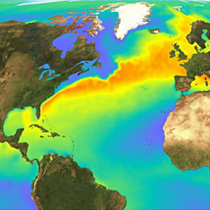 Raises air temperatures, thereby helping to deliver mild winters and cool summers to the British Isles. The warmer waters have a significant impact on North Atlantic temperatures as they give up about one-third of the energy they had previously stored from the sun. The extent of the warmth provided by the Gulf Stream can be seen by comparing the climate of countries at a similar latitude to Britain's - i.e Canada which is a bit colder! It is believed that the UK climate is 5°C warmer than it would be without the Gulf Stream. Warming effect of Gulf Stream prescence enabled agricultral productivity to increase, permitting an acclerated transition through the early stages of the Rostow Model of Development.
Perhaps the easiest way to understand the benefits of having the Gulf Stream nearby is to summarise the impacts on society if it was absent. Whilst there are many extrinsic forcing factors capable of shutdowning THC, thereby causing a southward shift or even complete shutdown of the Gulf Stream, the most likely is a large freshwater input at high latitudes due to melting ice, consequential to global climate change.........
How would the UK cope without the Gulf Stream?
This area is currently recieving a lot of attention (this is what I focused on when at the Met Office) and model simulations suggest that freshwater forcing of a shutdown, as a result of global climate change, could cause:
- 8C cooling
- Increase in wind speed
- Precipitation reduction
- Storms tending further north so hitting UK with increasing frequency
- 1-2 months additional snow cover
- 80cm sea level rise
- 2% reduction in the UK's GDP
 Sea level rise is potentially worrying for the UK as factoring in isostatic readjustment, population growth forcing more onto marginal lands and £130 billion worth of assets currently at risk of coastal flodding, greater than 10% as present, of our coastline would need to be protected. Even factoring in global climate change, the UK would still see reduced precipitation and 3C reduction in temperature. Increased snow cover would drastically decrease mobility, isolate people from an alrady straioned health care amongst other amenities, instigate higher living costs due to restrictions on agriculutre and issues with transporting food (in 2010 one milk company had to throw away 100,000 litres of milk) and cause huge disruption to education (altough, I don't think us students would mind a few more snow days!!!). Lower temperature and prolonged snow cover could cause issues for the UK's ageing population, with 1/4 in the southwest unable to heat their homes, possibly initiating greater urbanisation with cities able to offer facilities in close proximity, more likely to recieve greater funding for protection and the urban heat island effect warming, on average, summar and winter by 5C and 2C respectively. Consequently, a shift in employment could be experienced, with construction work becoming more seasonal and people looking for office-based work that can be completed from home during winter moths. Restricted agricultural and inducstrial productivity, fewer TNC's attracted whose presence stimulats cumulative causation and reduced touristic value, amongst other factors, is projected to generate a 2% reduction in the UK's GDP (-0.1% of global economy) with politicians put under increasing pressure to develop effective contingency plans to prevent societal collapse during protracted snow cover, minimise economci impacts and provide sufficient protection in coastal areas.
Global Impacts???
 The two hemispheres and the atmosphere and oceans are coupled in a way we don't need to understand but this means that, despite centralisation of impacts in the North Atlantic, impacts would be globally experienced. A 1C temperature increase in projected in the Southern Hemisphere, which would only be accentuated by global warming. A southward shift in the ITCZ would occur, reducing monsoon intensity/duration over India - worrying as India's water security is already poor, their rivers are reliant on glaciers, sea-level is threatening to displace millions thus increasing population density and India's population is expected to exceed China's by 2030. A 5% reduction in global NPP would be accompanied by alterations in temperate biome distribution and ecosystem disruption whilst with 20% of the world's fisheries dependent on upwelling systems and risng SST's futher reducing ocea oxygen content, food scarity would become prevalent especially with the global population soaring to 9 billion by 2045.
As you might have guessed, I find all of this stuff really interesting but I get the impression all you really need to know is the basic's of the Gulf Stream formation, a bit about how it has helped the UK and, just that society would struggle to sustain current livestyles without it - so hopefully this all made sense!
Sunday, 4 March 2012
Atmospheric Circulation
Global Heat Budget - Key Points:
- Excess at Equator
- Deficit at Poles
---> Therefore, as basic rules of thermodynamics dictates, all air and ocean currents transport heat polewards
Convection Cells (= essentially the same as that in the mantle)
- Incoming UV radiation heats the ground and is absorbed before being re-emitted as longwave terrestrial radiation.
- Hot air rises, generating low pressure (cloud formation and precipitation results), until it reaches the tropopause where it is forced to diverge.
- As it cools, it starts to sink, generating high pressure (dry conditions)
- Air will then move back to the source region along the surface, from the area of high pressure to an area of low pressure along the Equator

--> If the Earth did not rotate and there was no landmasses on Earth, then two convection cells (one in each hemisphere) would exist, moving heat from the Equator to the Poles. However the Earth does rotate in a anit-clockwise direction, influencing the atmospheric and oceanic circulation pattern......
Coriolis Force
If the Earth didn’t rotate then both the atmospheric and oceanic circulation would circulate to and from the polar regions (high pressure) to the Equator (low pressure) in a continual motion. However, the incessant eastward rotation of the Earth causes a more complex pattern of movement. The circumference of the Earth is greatest along the Equator and so the eastward motion of the Earth’s surface is greatest here; whereas at the poles, where circumference is at is minimum, the velocity is zero. Therefore, if a volume of fluid (or any moving particle) flows north from the Equator; it will sustain its constant eastward momentum but, as it gets within a forever closer proximity to the Poles, the Earth beneath it will gradually slow, thereby provoking air/water to move to the right, in relation to the Earth. Its general effect on flows is to cause them to turn to the right (east) as they progress north from the Equator and to the left (west) as they migrate south from the Equator. This is the Coriolis Effect and its strength increases as the water (or wind) moves further away from the Equator and thus, the distance that the currents flow away from the Equator governs how far, to the left or the right, they ‘bend’.

 - Intense insolation on the Equator starts the process of convection, leading to the formation of Hadley, Ferrel and Polar Cells
- The same pattern is seen in the southern hemisphere
- Wind pattern can be explained by the rule that air moves from excess to deficit as with each example the wind is blowing from areas of high pressure to low pressure, and then deflected by Coriolis
- Winds are named from the direction they are blowing from
- Trade Winds are so named due to their use in early trade, most infamously the Slave Trade - this provides a great synopitic link to development, colonialism and globalisation
Air Pressure Systems
 - Rising air moves in an anti-clockwise direction and spirals upwards = depression = low pressure

 --> The junction near the Equator where the two Hadley cells land based currents meet
I hope this is helpful - let me know if there is something I did not explain very well. On to Jet Streams and Rossby Waves next!!!
- Excess at Equator
- Deficit at Poles
---> Therefore, as basic rules of thermodynamics dictates, all air and ocean currents transport heat polewards
Convection Cells (= essentially the same as that in the mantle)
- Incoming UV radiation heats the ground and is absorbed before being re-emitted as longwave terrestrial radiation.
- Hot air rises, generating low pressure (cloud formation and precipitation results), until it reaches the tropopause where it is forced to diverge.
- As it cools, it starts to sink, generating high pressure (dry conditions)
- Air will then move back to the source region along the surface, from the area of high pressure to an area of low pressure along the Equator

--> If the Earth did not rotate and there was no landmasses on Earth, then two convection cells (one in each hemisphere) would exist, moving heat from the Equator to the Poles. However the Earth does rotate in a anit-clockwise direction, influencing the atmospheric and oceanic circulation pattern......
Coriolis Force
If the Earth didn’t rotate then both the atmospheric and oceanic circulation would circulate to and from the polar regions (high pressure) to the Equator (low pressure) in a continual motion. However, the incessant eastward rotation of the Earth causes a more complex pattern of movement. The circumference of the Earth is greatest along the Equator and so the eastward motion of the Earth’s surface is greatest here; whereas at the poles, where circumference is at is minimum, the velocity is zero. Therefore, if a volume of fluid (or any moving particle) flows north from the Equator; it will sustain its constant eastward momentum but, as it gets within a forever closer proximity to the Poles, the Earth beneath it will gradually slow, thereby provoking air/water to move to the right, in relation to the Earth. Its general effect on flows is to cause them to turn to the right (east) as they progress north from the Equator and to the left (west) as they migrate south from the Equator. This is the Coriolis Effect and its strength increases as the water (or wind) moves further away from the Equator and thus, the distance that the currents flow away from the Equator governs how far, to the left or the right, they ‘bend’.
- Surface winds/currents moving towards the Equator are deflected to the west
- Surface winds/currents blowing towards the Poles are deflected to the east
- Along the Equator majpr currents flow from east to west
Therefore, in reality there are six convection cells in operation on Earth.....
Tri-Cellullar Model of Atmospheric Circulation

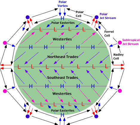 - Intense insolation on the Equator starts the process of convection, leading to the formation of Hadley, Ferrel and Polar Cells
- The same pattern is seen in the southern hemisphere
- Wind pattern can be explained by the rule that air moves from excess to deficit as with each example the wind is blowing from areas of high pressure to low pressure, and then deflected by Coriolis
- Winds are named from the direction they are blowing from
- Trade Winds are so named due to their use in early trade, most infamously the Slave Trade - this provides a great synopitic link to development, colonialism and globalisation
Air Pressure Systems
 - Rising air moves in an anti-clockwise direction and spirals upwards = depression = low pressure
- Falling air moves in a clockwise direction and spirals downwards = anticyclonic = high pressure = stronger of the two movements
ITCZ = Inter-Tropical Convergence Zone

 --> The junction near the Equator where the two Hadley cells land based currents meet
- Its position changes with regards to seasons.....
---> British Summer Time = ITCZ north of the Equator so low pressure over India (=rain!)
---> British Winter Time = ITCZ south of the Equator and higher pressure over India
- Over land the ITCZ shifts furhter north or south of the Equator die to differences in the albedo between land and the oceans
I hope this is helpful - let me know if there is something I did not explain very well. On to Jet Streams and Rossby Waves next!!!
Friday, 2 March 2012
Start of the Climate module!!!
This week we started the much anticipated climate module (at last!). Anyone who knows me will know that this is probably my favourite area we study so apologises to my class if my enthusiasm turns into annoyance! This means that I will definetly be providing you with plenty to read!!! So, lets get started...
WEATHER = the state of the atmosphere at a given time and place
CLIMATE = the average weather in a particular place over at least a 30 year period
The atmosphere is a mixture of gases, solids and liquids held in place by gravity, and it can be split into 4 layers differentiated by temperature changes:
 TROPOSPHERE:- this zone lies closest to the Earth and is weather processes take place. It displays the highest
temperatures as solar radiation warms the Earth's surface which, in turn, warms
the air directly above it (via convection, conduction and radiation). However,
this effect decreases rapdily with distance away from the surface and air
temperature drops by 6.4 degrees Celcius with every 1000m gained in height (= Environmental Lapse Rate or ELR). Wind
speeds also increase with increasing altitude as friction with the
surface decreases. This is the most unstable layer and contains
most water vapour and particulate matter. The end of the troposphere is marked
by the TROPOPAUSE which is an isothermal layer where the temperature remains
constant, despite the increase in altitude. The tropopause marks the upper limit
of the zone of weather and climate and jet streams are found here.
TROPOSPHERE:- this zone lies closest to the Earth and is weather processes take place. It displays the highest
temperatures as solar radiation warms the Earth's surface which, in turn, warms
the air directly above it (via convection, conduction and radiation). However,
this effect decreases rapdily with distance away from the surface and air
temperature drops by 6.4 degrees Celcius with every 1000m gained in height (= Environmental Lapse Rate or ELR). Wind
speeds also increase with increasing altitude as friction with the
surface decreases. This is the most unstable layer and contains
most water vapour and particulate matter. The end of the troposphere is marked
by the TROPOPAUSE which is an isothermal layer where the temperature remains
constant, despite the increase in altitude. The tropopause marks the upper limit
of the zone of weather and climate and jet streams are found here.
STRATOSPHERE:- this zone is characterised by a steady increase in temperature (known as a temperature inversion) as a result of solar radiation by the ozone layer. The ozone layer absorbs much of the incoming UV radiation that would be harmful to humans otherwise. Wind speeds increase with height towards the STRATOPAUSE.
MESOSPHERE:- temperature declines rapidly to c.-90 degrees Celcius in this zone as there is not water vapour or particulate matter to absorb radiation. It is characterised by very strong winds (often approaching 3000km/hr) and its end is marked by the MESOPAUSE.
THERMOSPHERE:- this is so named because of the increase in temperature resulting from the absorption of UV radiation by the atomic oxygen found at this altitude.
Latitude:
- Latitude greatly affects climate i.e rainforest on the Equator and deserts on the tropics, and its influence on climate affects other things too, arguably like development (think about latitudes at which most developed countries are situated.....)
- Latitude should have the same influence on climate in both hemispheres but it doesn't. Why? Well this is where you can link in tectonics - landmass is not equally distributed between the two hemispheres, with most continents in the Northern Hemisphere. Oceans take longer to heat up than land but are better at retaining heat and so different climates are experienced.
Global Heat Budget
 - More solar radiation is always absorbed at low latitudes compared to high latitudes. The Equator recieves more energy as solar radiation strikes the Earth head on.
- At high latitudes more radiation is lost as higher latitudes have a higher albedo so reflect the incoming UV radiation back as longwave terrestrial radiation. The 23.5 degree tilt means that at certain times of the year the poles recieve no insolation, whereas the Equator is always subject to intense insolation. Also, due to the Earth's angle of inclination, at the poels twice the area has to be heated and more atmosphere has to be passed through.
= The net result os a surplus of heat at the Equator
BASIC PRINCIPLE OF THERMODYNAMICS:- Heated substances always move away from their source towards cooler areas, hence the Earths circulatory system. This is the basis of both the atmospheric and oceanic circulation. Remember....
---> Substances ALWAYS move from areas of EXCESS to areas of DEFICIT
Factors affecting the heat budget:
WEATHER = the state of the atmosphere at a given time and place
CLIMATE = the average weather in a particular place over at least a 30 year period
The atmosphere is a mixture of gases, solids and liquids held in place by gravity, and it can be split into 4 layers differentiated by temperature changes:
 TROPOSPHERE:- this zone lies closest to the Earth and is weather processes take place. It displays the highest
temperatures as solar radiation warms the Earth's surface which, in turn, warms
the air directly above it (via convection, conduction and radiation). However,
this effect decreases rapdily with distance away from the surface and air
temperature drops by 6.4 degrees Celcius with every 1000m gained in height (= Environmental Lapse Rate or ELR). Wind
speeds also increase with increasing altitude as friction with the
surface decreases. This is the most unstable layer and contains
most water vapour and particulate matter. The end of the troposphere is marked
by the TROPOPAUSE which is an isothermal layer where the temperature remains
constant, despite the increase in altitude. The tropopause marks the upper limit
of the zone of weather and climate and jet streams are found here.
TROPOSPHERE:- this zone lies closest to the Earth and is weather processes take place. It displays the highest
temperatures as solar radiation warms the Earth's surface which, in turn, warms
the air directly above it (via convection, conduction and radiation). However,
this effect decreases rapdily with distance away from the surface and air
temperature drops by 6.4 degrees Celcius with every 1000m gained in height (= Environmental Lapse Rate or ELR). Wind
speeds also increase with increasing altitude as friction with the
surface decreases. This is the most unstable layer and contains
most water vapour and particulate matter. The end of the troposphere is marked
by the TROPOPAUSE which is an isothermal layer where the temperature remains
constant, despite the increase in altitude. The tropopause marks the upper limit
of the zone of weather and climate and jet streams are found here.STRATOSPHERE:- this zone is characterised by a steady increase in temperature (known as a temperature inversion) as a result of solar radiation by the ozone layer. The ozone layer absorbs much of the incoming UV radiation that would be harmful to humans otherwise. Wind speeds increase with height towards the STRATOPAUSE.
MESOSPHERE:- temperature declines rapidly to c.-90 degrees Celcius in this zone as there is not water vapour or particulate matter to absorb radiation. It is characterised by very strong winds (often approaching 3000km/hr) and its end is marked by the MESOPAUSE.
THERMOSPHERE:- this is so named because of the increase in temperature resulting from the absorption of UV radiation by the atomic oxygen found at this altitude.
Latitude:
- Latitude greatly affects climate i.e rainforest on the Equator and deserts on the tropics, and its influence on climate affects other things too, arguably like development (think about latitudes at which most developed countries are situated.....)
- Latitude should have the same influence on climate in both hemispheres but it doesn't. Why? Well this is where you can link in tectonics - landmass is not equally distributed between the two hemispheres, with most continents in the Northern Hemisphere. Oceans take longer to heat up than land but are better at retaining heat and so different climates are experienced.
Global Heat Budget

- At high latitudes more radiation is lost as higher latitudes have a higher albedo so reflect the incoming UV radiation back as longwave terrestrial radiation. The 23.5 degree tilt means that at certain times of the year the poles recieve no insolation, whereas the Equator is always subject to intense insolation. Also, due to the Earth's angle of inclination, at the poels twice the area has to be heated and more atmosphere has to be passed through.
= The net result os a surplus of heat at the Equator
BASIC PRINCIPLE OF THERMODYNAMICS:- Heated substances always move away from their source towards cooler areas, hence the Earths circulatory system. This is the basis of both the atmospheric and oceanic circulation. Remember....
---> Substances ALWAYS move from areas of EXCESS to areas of DEFICIT
Factors affecting the heat budget:
- The Solar Constant ---> varies slightly and affects longer-term climatic changes rather than shorter-term weather variations
- Eccentricity of Earth's Orbit ---> the eccentric orbit of the Earth around the sun can cause up to a 6% variation in the solar constant (this is linked to Milankovitch cycles which we get to learn about towards the end of the module!).
- Altitude of the sun in the sky ---> Equator receives intense insolation as UV radiation strikes Earth head on. At higher latitudes is approaches at a more oblique angle meaning there is twice the area to heat up and more atmosphere to pass through.
- Length of night and day ---> 23.5 degree tilt of Earth means that regions near the poles will not receive any insolation at certain times of the year.
- Sphericity and the Sun ---> higher latitudes make a lower anlge to the sun and the atmosphere is thicker whilst the poles are further away from the sun than the Equator


Intrusive Igneous Activity
 ---> Not all magma makes it to the surface to be extruded, some of it solidifies underground. The igneous rocks formed can contribute to surface geomorphology through uplift, erosion and exposure at the surface.
  SILLS = concordant (replaces a bedding plane)
i.e Whin Sill, Greenland, Palisades

DYKE = discordant (cuts through other bedding planes)
- A vertical intrusion that cuts through bedding planes, therefore discordant in raltion to bedding plane
- Spines of igneous material formed as where dykes cut through bedding rocks surrounding softer rock is easily eroded
i.e Arran dykes
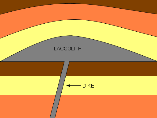
LACCOLITH
- Forms a small upwards, flat-bottomed, dome located within first kilometre of the surface
i.e Montana
BATHOLITH
- slowly cooled igneous rock, greater than 100km2
- produces lots of sandy beaches due to erosion of silica rich granite
- moors very boggy as granite is impermeable to water
- china clay formed by hydrolysis of feldspar within granite
- top of batholith, pressure release cracks, not layers, as weight has been removed
- very popular with climbers and possibilty to exploit geothermal energy = 'Hotrocks' project
i.e Dartmoor to Landsend
VOLCANIC PLUGS
 - Quite a lot of castles are built on old igneous intrusive landforms such as volcanic plugs
i.e Edinburgh
 GIANTS CAUSEWAY/FINGALS CAVE
- largest basltic lava flows that cooled slow enough to form columnar rock joints, forming hexagnol shapes. Middle parts cooled very slowly comapred to outside
- Gaps that appear between rock columns means it is vulnerable to freeze haw amongst other weathering processes
- Produces very steep-sided coastlines, cliff roughly on a 85 degree angle

Thursday, 1 March 2012
Minor Forms of Extrusive Volcanic Activity
Geysers and Hot Springs :- Even in areas where vulcanism does not generate active volcanies, water heated at depth in the crust by magma chambers can periodically escape as steam and hot water. A geyser is an intermittent turbulent discharge of superheated water ejected and accompanied by a vapour phase. Where hot water on its way upwards mixes with muds near the surface, a bubbling, boiling mud volcano may form. In some places hot springs have become tourist attractions: in Pamukkale (Turkey), dissolved salts from the hot water are lard down in spectacular calcium carbonate deposits, though the area is not volcanically active (read past post on this here).
 Geysers
- hot pressurised water, stored in rock cavities underground which increases pressure
- normally find a small mound surrounding a pool of water. The water is very mineral enriched and when it 'splatters' minerals are deposited, forming the mound.
- pools are incredibly colourful due to dissolved minerals
- periodically form a fountain
i.e Old Faithful (Yellowstone National Park), Geysir (Iceland), New Zealand
 RISKS - hot water and sulphurous gases
BENEFITS - tourism and geothermal energy exploitation oppurtunities
Hot Springs
- pool of warm geothermally heated water
- less pressurised water, hence no fountains
- water laden with minerals
i.e Japan, BlueLagoon (Iceland - technically a manmade version)
RISKS - very hot water
 BENEFITS - tourism and social
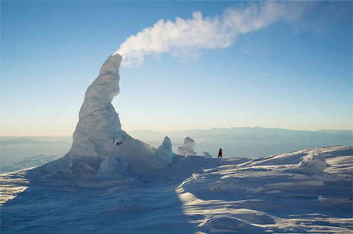
Fumaroles:- Fumaroles are ares where superheated water turns to steam as it condenses on the surface. Personally, I think they look most spectacular when they form in ice, like those on Mount Erebus (this a film review but also contains a description of such fumaroles)
Fumaroles
 - superheated water turns to steam, rises and deposits minerals to form chimney-like structures
i.e Stromboli, Erebus
RISKS - hot steam and sulphorous gases
BENEFITS - tourism and mineral extraction
Mudpots
 - water geothermally heated, interacts and mixes with mud and surface deposits
i.e Vulcano
RISKS - slightly radioactive and very hot
BENEFITS - tourism

Volcanic Hazards and Management
I am sure everyone is aware of the varying impacts of hazards around the world (Millie has written a very interesting post comparing recovery after the Christchurch, Great Honshu and Haiti earthquakes - it is worth checking out!) and volcanic hazards are no different. Much of this variation is dictated by degree of development but it is important to note that, due to our ability to predict them, no one anywhere in the world should really die as a direct consequence of an eruption. Instead it is the secondary impacts that cause the most problems.
Gas
- All volcanic eruptions are caused by gas escaping from magma with the viscosity of magma determing the ease at which gases escape
- High viscosity = explosive eruption with pyroclastics
- Low viscosity = effusive fumaroles with fire fountains and lava
- Active volcanoes produce large volumes of water vapour, carbon dioxide, chlorine, hydrogen sulphide, hydrogen, helium, hydrogen monoxide, hydrogen chloride, amongst other nasty gases. Fortunately they rarely reach lethal levels in populated areas but as carbon dioxide is denser than air it can collect in depressions which allow concentrations to build up to a level capable of suffocation.
- Lake Nyos, 1986, is the only example of gas killing people.
 - August 21st, 1986, limnic eruption occured, triggering sudden release of 1.6 billion tonnes of carbon dioxide. As carbon dioxide is 1.5 times more dense than air, the cloud suffocated some 1,700 people within 20km of the lake and 3,500 livestock. A further 4,000 people fled the area, with many developing health problems a as result of exposure to this hazard.
--> Degassing the lakes is a form of managment as by capturing the gas the risk is minimised. Important to note that 1986 was the first limnic eruption we have known to occur as there is no record of past eruptions. Therefore we were unaware that such a hazard existed. Now, degassing columns have been placed into the lake. The same has been done with Lake Kivu which contains methane. The difference here is that the degassed methane is beign used to run powerstations to provide electricity, aiding development.
Lava Flows
 - Only basaltic lavas are 'runny' enough to travel far from their source. Although all lavas slow as they start to cool, basaltic lavas often destroy property but rarely kill people as flows are predictable
- Nyiragongo is the only example where people have died - in 1977, 70 people were killed. Most recent eruption was 2002 when 300,000 people were forced to flee into neighbouring Rwanda and 15% of Goma was consumed.
--> Management is possible as was seen during the 1973 eruption of Heimaey (Iceland) and Etna. In both cases the lava flows were diverted away from populated areas.
Pyroclastic Flows
 - Mixture of rock, gas, magma blasted out of composite volcanoes.
- Viscous lavas
- Travel at over 300mph with inner temperatures of 500C
- Deadly killers as can affect up to 40km from the vent, travelling in all directions
- Examples = Mount St Helens, Pinatubo and Unzen
--> Only management is effective evacuation, which is reliant on good prediction, as nothing can really stop a pyroclastic flow
Lahars
 - Can be set off by the eruption by the melting of a summit glacier - e.g Nevado del Ruiz and Iceland (jokulhlaup)
- Or caused by rain mixing with ash and causing massive continuous flooding - e.g PInatubo, although eruption was last in 1991, a tropical cyclone passed over the area last year provoking a lahar
Landslides
- Landlisdes set off by the eruption can cause destruction
- Mount St Helens eruption was caused by a landslide
- Landslides also can cause tsunamis on islands and coastal volcanoes i.e Stromboli and Krakotoa
Ash
- Ash causes total destruction for hundreds of square kilometres
- Building collapse is most common cause of death due to volcanic hazards
- Destroys land and kills animals. Contaminates water supplies and sets like concrete with rain
- Can cause global cooling and reduce rate of sea level rise - e.g Pinatubo cooled world temperatures by 1C for 5 years
- Economic impacts with disruption to air travel - e.g Iceland E-15 eruption
Good Managment Case Studies
- Prediction - now very advance with volcanoes
- Hazard mapping i.e of past eruptions
- Monitoring - many of the worlds volcanoes, especially those near densely populated areas, are monitored
- Evacuation plans and procedures
- Education
- Hard engineering management such as lava flow diversion
Key Points:
- The variation of impacts is controlled by the type of volcanic eruption (therefore in an essay on hazards you could slip in some of your knowledge on silica content etc.)
- Further variation is provoked by degree of development
- If we knew were the volcanoes were it is unlikely we would have settled there! However, the offerded fertile lands to earlier settlers and since then many have grown into densely populated cities. It is unlikely that we will just move the cities away from the hazard (will be interesting to see what decision is made with Christchurch though!) and as population continues to expand more people will come into contact with the risk. Therefore there is an increasing need for management.
REMEMBER:- A hazard does not necessarily put you at risk.....
Hazard = the way in which an object or situation may cause you harm
Risk = the chance that harm will occur
Disasters only occur when people come into close contact with a hazard, hence why the risk will increase as global population expands and more are forced onto marginal lands.
- Nowadays people shouldn't really die directly from volcanic hazards due to our ability to predict them, but people do - why?
Gas
- All volcanic eruptions are caused by gas escaping from magma with the viscosity of magma determing the ease at which gases escape
- High viscosity = explosive eruption with pyroclastics
- Low viscosity = effusive fumaroles with fire fountains and lava
- Active volcanoes produce large volumes of water vapour, carbon dioxide, chlorine, hydrogen sulphide, hydrogen, helium, hydrogen monoxide, hydrogen chloride, amongst other nasty gases. Fortunately they rarely reach lethal levels in populated areas but as carbon dioxide is denser than air it can collect in depressions which allow concentrations to build up to a level capable of suffocation.
- Lake Nyos, 1986, is the only example of gas killing people.
 - August 21st, 1986, limnic eruption occured, triggering sudden release of 1.6 billion tonnes of carbon dioxide. As carbon dioxide is 1.5 times more dense than air, the cloud suffocated some 1,700 people within 20km of the lake and 3,500 livestock. A further 4,000 people fled the area, with many developing health problems a as result of exposure to this hazard.
 --> Degassing the lakes is a form of managment as by capturing the gas the risk is minimised. Important to note that 1986 was the first limnic eruption we have known to occur as there is no record of past eruptions. Therefore we were unaware that such a hazard existed. Now, degassing columns have been placed into the lake. The same has been done with Lake Kivu which contains methane. The difference here is that the degassed methane is beign used to run powerstations to provide electricity, aiding development.
Lava Flows
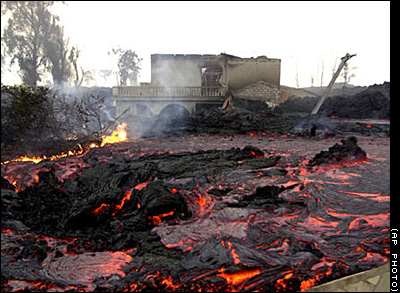 - Only basaltic lavas are 'runny' enough to travel far from their source. Although all lavas slow as they start to cool, basaltic lavas often destroy property but rarely kill people as flows are predictable
 - Nyiragongo is the only example where people have died - in 1977, 70 people were killed. Most recent eruption was 2002 when 300,000 people were forced to flee into neighbouring Rwanda and 15% of Goma was consumed.
--> Management is possible as was seen during the 1973 eruption of Heimaey (Iceland) and Etna. In both cases the lava flows were diverted away from populated areas.
Pyroclastic Flows
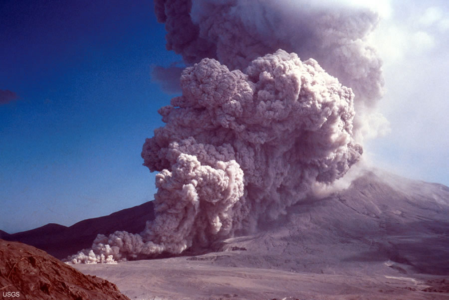
- Viscous lavas
- Travel at over 300mph with inner temperatures of 500C
- Deadly killers as can affect up to 40km from the vent, travelling in all directions
- Examples = Mount St Helens, Pinatubo and Unzen
--> Only management is effective evacuation, which is reliant on good prediction, as nothing can really stop a pyroclastic flow
Lahars
 - Can be set off by the eruption by the melting of a summit glacier - e.g Nevado del Ruiz and Iceland (jokulhlaup)
- Or caused by rain mixing with ash and causing massive continuous flooding - e.g PInatubo, although eruption was last in 1991, a tropical cyclone passed over the area last year provoking a lahar
Landslides
- Landlisdes set off by the eruption can cause destruction
- Mount St Helens eruption was caused by a landslide
- Landslides also can cause tsunamis on islands and coastal volcanoes i.e Stromboli and Krakotoa
Ash
- Ash causes total destruction for hundreds of square kilometres
- Building collapse is most common cause of death due to volcanic hazards
- Destroys land and kills animals. Contaminates water supplies and sets like concrete with rain
- Can cause global cooling and reduce rate of sea level rise - e.g Pinatubo cooled world temperatures by 1C for 5 years
- Economic impacts with disruption to air travel - e.g Iceland E-15 eruption
Good Managment Case Studies
- Lava flows of basaltic eruptions = Etna and Heimaey
- Channelling of lahars = Japan
- Prediction success = Pinatubo, Unzen and Montserrat
- Prediction failure = Nevado del Ruiz, Mount St Helens
- Prediction - now very advance with volcanoes
- Hazard mapping i.e of past eruptions
- Monitoring - many of the worlds volcanoes, especially those near densely populated areas, are monitored
- Evacuation plans and procedures
- Education
- Hard engineering management such as lava flow diversion
Key Points:
- The variation of impacts is controlled by the type of volcanic eruption (therefore in an essay on hazards you could slip in some of your knowledge on silica content etc.)
- Further variation is provoked by degree of development
- If we knew were the volcanoes were it is unlikely we would have settled there! However, the offerded fertile lands to earlier settlers and since then many have grown into densely populated cities. It is unlikely that we will just move the cities away from the hazard (will be interesting to see what decision is made with Christchurch though!) and as population continues to expand more people will come into contact with the risk. Therefore there is an increasing need for management.
REMEMBER:- A hazard does not necessarily put you at risk.....
Hazard = the way in which an object or situation may cause you harm
Risk = the chance that harm will occur
Disasters only occur when people come into close contact with a hazard, hence why the risk will increase as global population expands and more are forced onto marginal lands.
- Nowadays people shouldn't really die directly from volcanic hazards due to our ability to predict them, but people do - why?
Tuesday, 28 February 2012
How are lava type, volcano shape and eruption style linked?
So, I have covered all the boundary types and seeing as I have had a lot of requests on this topic I thought I would move on to the different volcano types and what dictates their formation. Sorry that there has not been much activity on here for a while but there is lots on its way to make up for it!!!
I have to admit that I think the fact that silica, alone, can be used to link all this volcano stuff together is pretty amazing (and surely I can't be the only one!) but how excatly is this the case......
How are lava type, volcano shape and eruption style linked?
I have to admit that I think the fact that silica, alone, can be used to link all this volcano stuff together is pretty amazing (and surely I can't be the only one!) but how excatly is this the case......
How are lava type, volcano shape and eruption style linked?
Wednesday, 8 February 2012
Convergent Boundaries
Oceanic vs Oceanic
 STAGE 1 - Subduction produces partial melting and the formation of a chain of volcanoes = island arc
STAGE 2 - Build up of intrusive and extrusive igneous material, mixed with sediments, forms larger material
STAGE 3 - The island chain joins up and sediments form an accretionary wedge or prism which builds on to the fore arc area
When the plates collide, one is usually slightly denser than the other, or one is moving slightly faster then the other, so subduction occurs. Consequential subduction and its appending processes are much the same as with oceanic vs continental convergence. When volcanoes erupt islands can form and they usually form characteristically curving lines of new volcanic land (island arcs), with deep trenches. They islands can evolve over millions of years to form major landmasses, like Japan and Indonesia.
Hazards
- Volcanoes = wide cariety of typesm explosive and effusive
- Earthquakes = can be very powerful such as in Indonesia in 2004
- Tidal waves = offshore earthquakes generates waves and the steep islands often suffer inundation, the other cause is collapse of oceanic islands i.e Stromboli
Oceanic vs Continental
 STAGE 1 - Weight of continental sediment causes subsidence of the crust
STAGE 2 - Subduction develops and an island arc forms
STAGE 3 + 4 - Compression from plate movement cause the crust to thicken and shorten through folding and thrust faulting. Fold mountain chains are formed i.e the Andes
- Mount St Helens was formed in this way, the Cascades represent the curved line of volcanoes jusr inland on the Western Seaboard
- Thicker the crust the more explosive the volcano is
 Oceanic crust is denser than continental crust so when they collide the oceanic crust is subducted. As oceanic crust descends, friction with the overlying crust builds up, generating powerful shallow-to-deep focus earthquakes that chart the descent of subducting crust. Rocks scraped off the descending plate and folding of continental crust aids fold mountain formation, whereas deep trenches form along the seaward edge of convergent boundaries. Friction generated by subduction processes generates lots of heat that enables partial melting of the crust. Consequently magmas derived from here are less dense than the mantle so it rises up through fissures until it reaches the surface. This magma is also silica enriched, therefore more viscous, hence the explosive volcanic eruptions and presence of intrusions like batholiths.
Hazards
- Very explosive volcanoes i.e Mount St Helens and Popacatepetl
Structure of Subduction Zones

- The shallower the angle of subduction, the greater the Benioff zone, therefore earthquakes can be felt over a larger area. This means it is better/safer to live in an area with a greater angle of subduction.
Characteristics of Subduction Zones
- Trenches - generally 5-8km deep, although Mariana Trench is 11km
- Belt of earthquakes with the shallowest experienced closest to the trench
- Island arcs (archipelago) form, which are usually curved i.e the Aleutian Islands
Continental vs Continental
 --> This is the process of mountain building as it often reffered to as ab Orogeny, and the moutains as Orogenic Belts
- We are currently in the Himalayan orogeny, where the process of continental collision is still active today
 - Over the last 100ma, India has moved northwards. The Himalayan orogeny started well below the equator where an ocean existed to its north called Tethys. The subduction of the oceanic lithosphere thickened the plate to 100km and forced up the fold mountains.
Continental plates have similar densities and their buoyancy means no subduction occurs. Instead, they are associated with orogeny. Volcanics associated with earlier subduction and sediments scraped off the vanishing ocean floor are mixed up and compressed to form young fold mountain chains with deep roots in the lithosphere.
Hazards
- Plate has moved very rapidly (200mm/yr)
- Earthquakes occur often
- Crust is too thick for diapirs of magma to make it to the surface so there are no volcanoes
- Mass movement
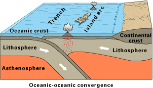 STAGE 1 - Subduction produces partial melting and the formation of a chain of volcanoes = island arc
STAGE 2 - Build up of intrusive and extrusive igneous material, mixed with sediments, forms larger material
STAGE 3 - The island chain joins up and sediments form an accretionary wedge or prism which builds on to the fore arc area
When the plates collide, one is usually slightly denser than the other, or one is moving slightly faster then the other, so subduction occurs. Consequential subduction and its appending processes are much the same as with oceanic vs continental convergence. When volcanoes erupt islands can form and they usually form characteristically curving lines of new volcanic land (island arcs), with deep trenches. They islands can evolve over millions of years to form major landmasses, like Japan and Indonesia.
Hazards
- Volcanoes = wide cariety of typesm explosive and effusive
- Earthquakes = can be very powerful such as in Indonesia in 2004
- Tidal waves = offshore earthquakes generates waves and the steep islands often suffer inundation, the other cause is collapse of oceanic islands i.e Stromboli
Oceanic vs Continental
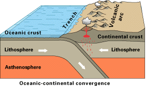 STAGE 1 - Weight of continental sediment causes subsidence of the crust
STAGE 2 - Subduction develops and an island arc forms
STAGE 3 + 4 - Compression from plate movement cause the crust to thicken and shorten through folding and thrust faulting. Fold mountain chains are formed i.e the Andes
- Mount St Helens was formed in this way, the Cascades represent the curved line of volcanoes jusr inland on the Western Seaboard
- Thicker the crust the more explosive the volcano is

Hazards
- Very explosive volcanoes i.e Mount St Helens and Popacatepetl
Structure of Subduction Zones

- The shallower the angle of subduction, the greater the Benioff zone, therefore earthquakes can be felt over a larger area. This means it is better/safer to live in an area with a greater angle of subduction.
Characteristics of Subduction Zones
- Trenches - generally 5-8km deep, although Mariana Trench is 11km
- Belt of earthquakes with the shallowest experienced closest to the trench
- Island arcs (archipelago) form, which are usually curved i.e the Aleutian Islands
Continental vs Continental
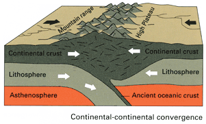 --> This is the process of mountain building as it often reffered to as ab Orogeny, and the moutains as Orogenic Belts
- We are currently in the Himalayan orogeny, where the process of continental collision is still active today
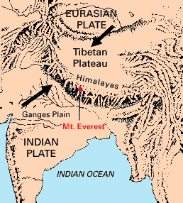 - Over the last 100ma, India has moved northwards. The Himalayan orogeny started well below the equator where an ocean existed to its north called Tethys. The subduction of the oceanic lithosphere thickened the plate to 100km and forced up the fold mountains.
 Continental plates have similar densities and their buoyancy means no subduction occurs. Instead, they are associated with orogeny. Volcanics associated with earlier subduction and sediments scraped off the vanishing ocean floor are mixed up and compressed to form young fold mountain chains with deep roots in the lithosphere.
Hazards
- Plate has moved very rapidly (200mm/yr)
- Earthquakes occur often
- Crust is too thick for diapirs of magma to make it to the surface so there are no volcanoes
- Mass movement
Wilson Cycle = Opening and Closing of Oceans
Rifting controls the opening and closing of oceans. The cycle is known as the Wilson Cycle and it illustrates the balance between new crust being created by volcanic eruptions and destruction of crust at subduction zones, to maintain Earth's fixed size. This helps to explain why there are subduction zones at the edges of most continents.
 There are various stages to the Wilson Cycle and each one can be seen in operation across the world today:
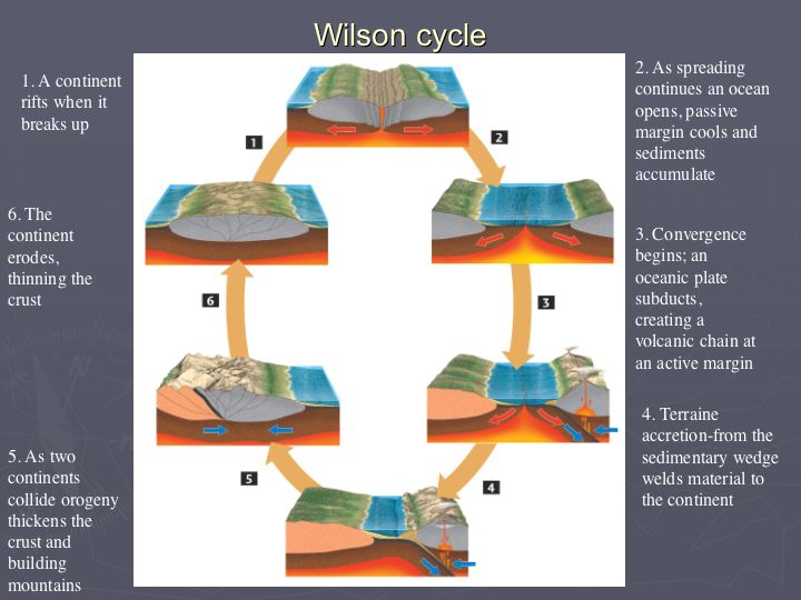
- The embryonic stage, involves uplift and continental crust extention, resulting in the the formation of rift valleys (e.g. the East African Rift System).
- The young stage involves the evolution of rift valleys into spreading regions with thin strips of ocean crust between the rifted continental sections. This forms a narrow, parallel-sided sea, like the Red Sea that is opening between NE Africa and Arabia.
- The mature stage is characterised by widening of basin and its continued development into a major ocean flanked by continental shelves and with the continual production of new, hot, oceanic crust along the ridge (e.g. Atlantic Ocean).
- Eventually, this expanding system becomes unstable and, away from the ridge, the oldest oceanic lithosphere sinks back into the asthenosphere, forming an oceanic trench subduction system, such as the situation in the western Pacific Ocean. Onset of subduction at the ocean boundary marks the subduction stage (e.g. the Pacific Ocean).
- Once subduction overtakes formation of new crust at the constructive boundary, the ocean begins to 'shrink'. Island arc's collide and create young mountain ranges around the periphery of the 'shrinking' ocean. This marks the terminal stage of the cycle (e.g. the Mediterranean).
- The end stage occurs when all the oceanic crust between the continental masses has subducted, and the continents converge along a collision zone characterised by an active fold mountain belt, such as the Himalayas. The plate boundary becomes inactive, but the boundary between the two plates remains as a zone of lithospheric weakness. Therefore it has the potential to the site of a new rift and so the cycle continues.
Divergent Boundaries
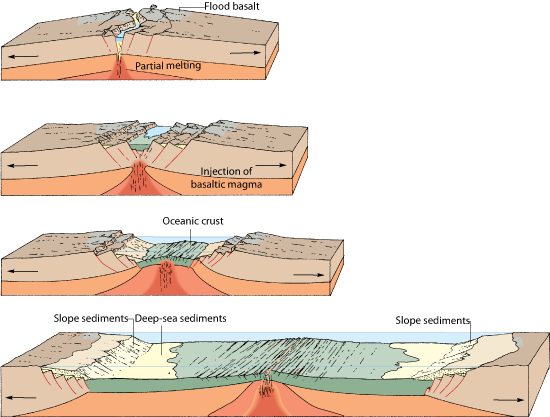 One of the plate margins is divergent (constructive) and this, in short, is when plates move away from each other, thereby generating tensional forces. As such, they are characterised by shallow-focus earthquakes and volcanism, producing volcanoes which erupt basaltic magma (unevolved) via Icelandic and Hawian style eruptions.
 - Start intra-plate
- Upwelling of magma in a plume, driven by thermo-nuclear reactions in the Gutenburg Discontinuity
- Plume rises and convection starts at the base of the lithosphere
- Convection currents rise and then diverge, creating high temperatures that cause updoming of the crust, along with tensional forces that pull it apart
- In continental crust this can produce rift valley systems such as the East African Rift Valley
- In oceanic crust, new oceanic crust is produced as oceanic ridges are created and seafloor spreading occurs
Rifting
- As convection commences the plate is thinned out by a series of extention faults
- As the plate gradually becomes thinner, volcanoes and lakes start to form in the valley
- More volcanoes continue to form until a complete ridge exists, the plate is forced apart and new basaltic oceanic crust begins to form on either side
- As the lakes connect, and the level of the land drops, the ocean floods the valley and forms an elongated sea such as the Red Sea
e.g East African Rift Valley System where eventually a new plate will form (called the Somalia Plate, and the rest of Africa, the Nubia Plate). The sea will eventually flood the valley, connecting to the Red Sea.

 e.g Where spreading occurs beneath major landmasses, heating and subsequent updoming leads to fracturing and rifting. As the sides of the rift move apart, central sections drop down to form rift valleys. The Great East African Rift Valley, indicates where the crust has begaun to pull apart, and active volcanoes such as Mount Kilimanjaro and Mount Kenya are surface evidence of igneous activity beneath. At 4000km long, up to 50km wide and 600m in depth, this feature might widen still, allowing sea inundation. To the north, two rifts have widened into the Red Sea and Gulf of Arabia. Here, the rifting has continued, with new sea floor forming between Africa on the south-western side and Arabia on the north-eastern side.
 - Other examples of past rift zones include the steep-sided valley of the River Rhine, athlough there are ancient volcanoes nearby to show how active this region once was, it is no longer subject to rifting.
Oceanic Ridges
 = Lines of submarine volcanoes that form a continuous feature throughout the world's oceans
= Centres of spreading where the youngest oceanic rocks are fund closest to the ridge
- They form the longest continuous uplifted feature, with a total combined length of over 60,000km

- Occur on divergent boundaries as a weaker zone is exposed to an increase in surface heat. Hotter crust expandsa new ridge forms and the central part of the ridge may feature a central valley if a section of crust has subsided into the magma below. This split in the crust provides a lower pressure zone where, if more lava erupts, submarine volcanoes can form. If such eruptions persist then volcanoes will develop until they reach the surface, with islands formed in this way i.e Iceland!

Transform Faults
- Spreading does not occur at the same rate along the ridge
- Transform faults offset the ridge, giving it a blocky appearance
- Distance between the fault varies and they are responsilbe for many undersea earthquakes, but due to a lack of vertical displacement, tsunami's are rarely generated
Hazards
- Frequent low grade seismicity (earthquakes below 5 on Richter Scale)
- Intense and frequent volcanism
- Ultra slow spreading = 10mm/yr i.e Atlantic, Ultra fast spreading = 100mm/yr i.e East Pacific and Galapagos
Tuesday, 7 February 2012
Back to tectonics (FINALLY!!!) - Conservative Margins and Hotspots summary
Hello everyone! I hope the exam went well for you all! We even got mention in the local newspaper - Twin Sails Bridge part of A-level exam - perhaps it would have been interesting to ask students if they would consider visiting Poole before and after studying the bridge for 2 months, then conduct a Mann Whitney U to see if there was a significant difference between number of students inclined to visit the area! Anyway I can now happily say that we will never have to study Poole/Twin Sails Bridge again!!! This means that we can finally get back to good old tectonics.....

 These margins are sometimes reffered to as passive or slip margins and occur where two plates meet and the direction of plate motion is either parallel or nearly parallel. No crust is destroyed or created, although these are areas of frequent seismic activity as the build up of friction as the plates pass each other is released by earthquakes. This boundary is not associated with volcanism.
- No subduction or abduction
- Plates try ot move laterally past each other
- Most infamous are the San Andreas Fault in the USA and the North Antolian Fault in Istanbul [both are overdue a huge earthquake!]
- No volcanism
- Generates massive earthquakes
Hotspots
- These are not boundaries, as such, but rather a surface representation of surface plumes
- Plates do not always split above mantle plumes, but as the plate moves over the magma source, it generates a chain of islands
- The oreintation of the island gives an indication of the direction of the plate movement relative to the plume
 Hawaii
 = Chain of islands, connected to the Emperor Seamount chain (submerged)
= The islands become progressively older to the northwest, indicating the plate is moving in this direction
= This was anticipated before the discovery of continental drift as the islands become shallower in gradient, more advanced vegetation succession and have deeper soils to the northwest.
Other hotspots
- Yellowstone Caldera is probably the niggest and highest risk
- Iceland is unusual being a large plume underneath a divergent boundary
This mantle plume theory is stil hotly debated and poorly understood - it is one of the few remaining mysteries of tectonic theory, which is otherwise now widely accepted.
Divergent and convergent boundary notes are on the way!
Correct me if I am wrong but I think before Christmas I only got as far as outlining the basics of this module, so I have quite a bit to catch up on! I have already lost count of the number of you who have asked very nicely for some case study orientated posts so I will try and find the time over the coming weeks to go over case studies whilst also finding the time to write about Iceland (apologises but I am starting to get a little excited and a condition of me going was that I don't talk about it at home!). For now though I will leave you with a few brief notes on conservative boundaries and hotspots (sorry if the image quality is a bit poor but I gave up trying to find good diagrams online so just photographed my notes) - I am hoping to cover all the volcano stuff this week so I can focus on earthquakes over half term so be warned that a lot of posts may appear over the coming days!
Conservative Margins
Conservative Margins

 These margins are sometimes reffered to as passive or slip margins and occur where two plates meet and the direction of plate motion is either parallel or nearly parallel. No crust is destroyed or created, although these are areas of frequent seismic activity as the build up of friction as the plates pass each other is released by earthquakes. This boundary is not associated with volcanism.
 - No subduction or abduction
- Plates try ot move laterally past each other
- Most infamous are the San Andreas Fault in the USA and the North Antolian Fault in Istanbul [both are overdue a huge earthquake!]
- No volcanism
- Generates massive earthquakes
Hotspots
- These are not boundaries, as such, but rather a surface representation of surface plumes
- Plates do not always split above mantle plumes, but as the plate moves over the magma source, it generates a chain of islands
- The oreintation of the island gives an indication of the direction of the plate movement relative to the plume

 = Chain of islands, connected to the Emperor Seamount chain (submerged)
= The islands become progressively older to the northwest, indicating the plate is moving in this direction
= This was anticipated before the discovery of continental drift as the islands become shallower in gradient, more advanced vegetation succession and have deeper soils to the northwest.
Other hotspots
- Yellowstone Caldera is probably the niggest and highest risk
- Iceland is unusual being a large plume underneath a divergent boundary
This mantle plume theory is stil hotly debated and poorly understood - it is one of the few remaining mysteries of tectonic theory, which is otherwise now widely accepted.
Divergent and convergent boundary notes are on the way!
Subscribe to:
Posts (Atom)