Just to ease you all into the subject, here is a little clip produced by the Met Office; on their youtube page they have lots of similar animations/videos for different parts of the climate module that cover the basics.....
 Jet Stream = fast flowing, meandering winds found at high altitudes (top of the troposphere), moving west to east (I find it easiest to think of them as 'rivers of air' - my reasoning should become clearer later!). They can travel up to 250km/hr and there are two in each hemisphere:
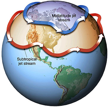
- Polar Jet = between polar and ferrel cells, 7 - 12km and fast moving
- Sub-tropical Jet = between hadley and ferrel cells, 10-16km and weaker due to greater circumference around the Earth
Why do Jet Streams exist?
 They are caused by extreme pressure differences in the troposphere generated by the decreasing height towards the poles
- Hadley Cell = 16km high
- Ferrel Cell = 12km high
- Polar Cell = 9km high
This high pressure gradient causes strong winds and as this pressure gradient is greatest at the junctions between the cells it is here that the jet streams are found. As with any moving substance it is deflected by the good old Coriolis Force so they move from west to east.
However, their path is not simple as they meander (just like rivers!). These meanders are known as Rossby Waves - the posh way of describing Rossby Waves is that they are undulations in the path of the Jet Stream that, when become more sinuous (again, just like rivers!) over time, cells of polar air break free.

- The crest of the wave (poleward end) starts to turn back towards the equator so the winds are slowed by Coriolis and so piles up. This causes convergence, therefore some air must move down towards the surface = anticyclones
- Where a trough (equatorward end) of the wave swings back to the poles, the winds are accelerated by Coriolis, leaving behind less air that the rest of the jet steam, and as such, sucks air up from the surface creating a low pressure system (divergence) = depressions
---> Generally more Rossby Waves occur in winter than in summer (normally 4 in summer, 6 in winter) as north/south pressure gradient is greater over winter when the poles are icy and this increasing strength of the pressure gradient generated more intense and frequent Rossby Waves
That is kind of the sciency bit out of the way but why should we care I hear you all cry! Well, these Jet Streams have great influence over weather.....
- The subtropical jet is found 25 -30 degrees north and south of the equator but does not cover Asia in the summer. This jet is associated with high levels of converging winds which create constant high pressure at the surface (air is sinking) - a crucial characteristic as winds are then forced to diverge, completing the Hadley and Ferrel Cells - this means practically constant anticyclonic conditions at this latitude, leading to formation of deserts
- The polar jet is found 40-60 degrees north and south - yes thats, right, that means it affects UK climate alot! When the polar jet is more southerly, it brings cold air down to the surface (high pressure). The warmed jet then travels northwards (rises, thereby generating low pressure) and brings rain = formation of depressions! Essentially the path of the ket stream steers cyclonic storms in the lower atmosphere and so are useful in relation to weather forecasting i.e 2007 UK floods result of polar jet moving south for the summer where it became stuck under trough of a Rossby Wave. Here is a Met Office blogpost explaining why the jet stream is to (partly) blame for unusual weather these past few months in the UK.....
So thats about it for jet streams I think, I hope it makes sense! Next up is depressions!
Thank you for your fascinating, well-written blog. After retiring, I got an iPad. Rather than vegetate, of an evening, or tv (same thing), I trawl around for something interesting. Your blog is by far the most riveting piece of work I have encountered in over two years. I send my best wishes to you and your teacher and greatest encouragement I can muster for you both to continue this wonderful dissemination of information. I was a deep sea diver and, being err... deeply involved with the elements, resolved to discover as much as I could before I croak.
ReplyDeleteWow, thanks, it is always so refreshing to here that people find this blog interesting! Well hopefully, if my exam results go to plan, I will be off to university in October so I will be able to blog about a lot more interesting things and to a higher level!
DeleteAll the best with everything
Delete