After much request, I am going to write a short post purely on the idea of rejuvenation in rivers (to those of you who I said that I would do it on Wednesday/Thursday, I apologise but blogger hasn't been working properly over the last few days). So, better late than never, here goes........
What is rejuvenation?
Rejuvenation is the renewal of a rivers energy in response to a relative fall in base level. Base level is the same as current sea level and so a drop in base level can be caused by either eustatic sea level fall, isostatic rebound or tectonic activity. Due to the fact that all rivers try to reach the graded profile (a theorectical concept where all three river processes are in equilibrium and calibrated to current base level), a drop in base level usually provokes a restart of erosion, predominantly in the form of vertical erosion. Rejuvenation always starts at the mouth of a river and works its way towards the soure, therefore headward erosion is also active.
How does rejuvenation affect rivers?
The restart of erosion and reduction in deposition, provoked by a fall in base level, leads to the formation of landforms that would not normally be found in rivers.
INCISED MEANDERS:
There are two types of incised meanders, ingrown and entrenched and they can be found in areas like the Grand Canyon.
Ingrown meanders:
:- form when lateral erosion operates too (therefore indicates a more gradual drop in base level) and so the valley floor is deepened which means that the channel only occupies part of it.
:- they have an asymmetrical cross section
Entrenched meanders:
:- created, purely, by vertical erosion (their presense indicates a rapid fall in base level) and often form in hard rock areas.
:- they are deep cut and gorge like
they have a symmetrical cross section
KNICK POINTS:
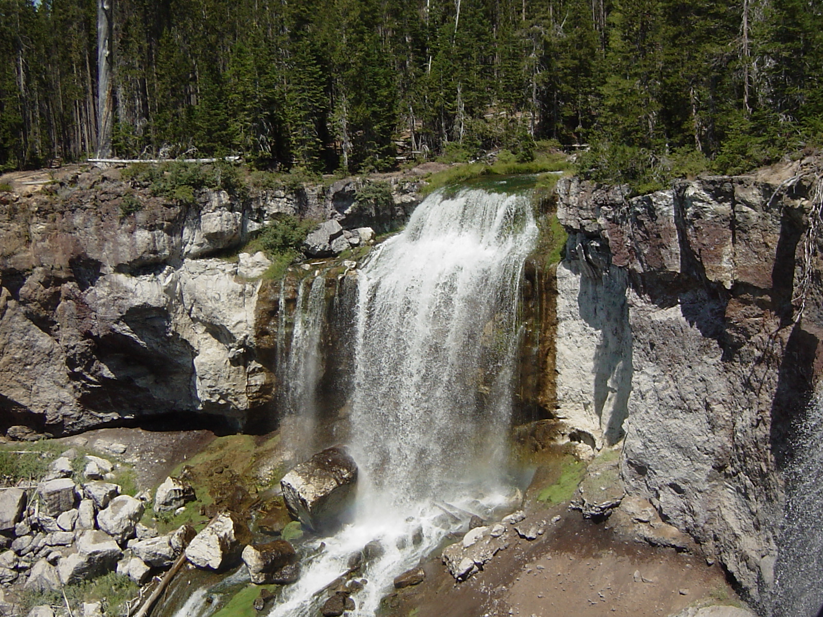
:- they can be identified by a break in slope and so are often marked by a waterfall
:- they reflect the process of headward erosion aswell as vertical erosion as the river has a renewed ability to erode vertically
:- Knick points often form waterfalls and, in areas where they form but there is no alteration in rock type, they clearly show rejuvenation has occured as waterfalls normally form due to differential erosion resulting in undercutting
RIVER TERRACES:
There are two types of river terraces, paired and unpaired, and they are the remains of the former floodplain which has been abandoned because the river has eroded too deeply for the floodplain to be accessed. London sits on river terraces and by looking at terraces it is possible to work out how many relative falls in base level have occured.
Paired:
:- they are on the same level on each side of the channel and so indicate rapid down cutting
Unpaired:
:- occur when the fall in base level is slower
:- the terraces will be present on different sides of the channel at different levels. This is because lateral erosion, through meander migration (so mainly hydraulic action and abrasion), has had time to occur
I hope this is helpful and in enough detail. It is quite a tricky area of the rivers model, especially if you are faced with a 15 mark question like 'Describe and explain the formation of landforms resulting from rejuvenation' as it is hard to think of enough to write about but hopefully this will give you an idea on where to start.
Good Luck with the revision over the weekend!
Can I ask what exam board you are doing? Is it OCR? if so this is so useful for my AS geography :)And would you be able to provide me with a link to your geography teacher's link as well please?
ReplyDeleteWe are actually doing AQA (I think!) but I am guessing there is quite a bit of overlap between different exam boards. At AS we study Rivers, Population, Engery and Coasts and then at A2 Development and Globalisation, Plate Tectonics and Associated Hazards and Climate and Associated Hazards, with skills exams in both years - hopefully therefore some of this may still be relevant to the OCR course. There is also stuff on here about other modules we don't study within our syllabus like glaciers etc.
DeleteMy teachers blog is called 'What I Taught in Geography This Week' and there is a link to it at the bottom of this blog, under Blogs I Read.
Good luck with AS Geography - I hope this blog is of some help!!!
Very well drafted post and self explanatory images used!
ReplyDeleteVein removal
this is very helpful..as i am working on Chambal Geomorphology
ReplyDeleteI am pleased you are finding it useful!
Delete