So, firstly, a bit of glacial terminology........
- ICE :- (I thought that frozen water would be enough, but apparently not) Ice is snow which has been compacted so that the air passages between the individual crystals of snow become sealed, thereby increasing the density. The density has to be greater than 0.85 for it to be classed as ice.
- GLACIER :- A moving mass of ice on a land suface
- ICE SHEET:- An ice sheet covering a plateau region, over an extensive area. Movement around the edges may be faster because of steeper gradients.
- CIRQUE GLACIER:- After snow has continued to accumulate in a hollow on a mountain side, ice forms and thickens with time. Ice fills the cirque (also known as a corrie) hollow, which is deepened. the glacier may grow to the point where it spills out of its semi-circular hollow into the valley below.
- VALLEY GLACIER:- A glacier following the line of a pre-existing river valley, fed by cirque glaciers or ice caps. These can be extremely deep and the moving tongue of ice can extend from some distance, down the valley, until it reaches the lowlands or the sea.
- PERIGLACIAL:- Applied to land areas which lie around the margins of ice sheets. They are cold areas where permafrost exists either continuously (everywhere) or discontinuously (in patches only).
- PERMAFROST:- Permanently frozen ground of which only the surface layer thaws breifly during summer. This layer is known as the active layer.
- 2 million years ago = the onset of the Pleistocene Ice Age
- There have been four major ice advances known as glacials
- These were seperated by warmer periods , called interglacials, where the ice retreated
- Anglian is the name given to the first glacial advance in Britain and it occured around 500,000 years ago
- The maximum ice advance was during the third glacial advance, known as the Wolstonian glaciation in Britain, which ended about 125,000 years ago
- The Ipswichian (also known as Eemian) interglacial period was particularly warm and so provoke great ice retreat
- The fourth and last ice advance ended around 25,000 years ago and was called the Devensian glaciation
- Progressive warming of the Earth (although there have been a few notable fluctuations) has occured since the end of the Devensian glaciation and the end of the Pleistocene Ice Age is usually dated as around 10,000 years ago
 Glaciers form when the amount of snow that falls throughout the year exceeds the amount which melts and they can only form above the permanent snow line. Most glaciers originate from a snow patch in a hollow on a mountain side. Once this hollow becomes filled with snow, the hollow itself, is enlarged by various types of weathering and nivation (the proper collective term for all the erosional processes that occur under a snow patch). This weathered material is then easily washed away by snow melt.
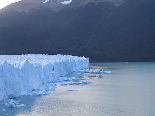
Freshly fallen snow has a low density (under 0.5) due to the large amount of air trapped between the individual crystal. However, as more snow falls and the snow patch enlarges, the old snow becomes compacted. More air is then expelled by the successive melting and refreezing and if the snow manages to last a year it turns into higher density firn or neve (which has a density of around 0.7). After further annual snowfall the firn becomes more and more compacted due to the sealing of further air spaces. The crystals start to grow larger, again increasing density, until the density grows to above 0.85 - the point at which snow is considered to be ice. This transition from snow to ice can take up to 200 years in areas like Antarctica as the continually low temperature prevents melting and refreezing, which speed up the process, or only around 5 to 10 years in slightly warmer martime environments such as Alaska.
Glaciers are examples of open systems. Their main input is snow, either from direct snowfall or from avalanches. This snow accumulates in the upper part of a glacier and is stored, in the system, as glacier ice which is carried downslope by the glaciers movement. The main output of this system is water (no surprise there!) and, although some water does evaporate directly from the surface, most water loss results from the ice melt as lower altitudes, or latitudes with higher temperatures, are reached. Further melting occurs at the sides, where the glacier meets rock with a much lower albedo than the glacier ice itself, and as internal or basal melting. On top of this you also get calving where icebergs break off into streams, lakes and the sea.
 Ablation is the term for the net loss of ice and above the snowline, the accumulation of snow is greater than ablation. The point where the systems outputs exceeds the inputs is reached when the zone in the course of a glacier where accumulation is replaced by the zone of ablation has been reached. When the amount of new snow and ice is excatly balanced by the amount that has melted, a steady state is said to exist and the glacier remains stationary. However, often the position of the break point between the zones of accumulation and ablation changes from year to year (or sometimes over a longer period of time). When the balance is lost the snout (the front of the glacier) of the glacier either advances or retreats. Despite the warming of the Earth over the last 10,000 years provoking greater retreat; colder interludes have allowed for local ice advances. One such interlude was the 'Little Ice Age', which lasted for around 500 years (starting in 1350) and reached its worst in the late seventeenth century when it was nearly cold enough for the re-development of the Laurentian ice sheet in North America (during this period the River Thames, famously, kept freezing over). However, current global warming is encouraging glacial retreat everywhere and calving great icebergs off the Antarctic ice mass with some ice masses being equivalent to size of smaller European countries and Mediterranean islands.
So, thats kind of the beginnings of the the stuff about glaciers that I am trying to understand - sorry I realise that it is a bit long and wordy but I am still banned from talking about anything Geography related at home and so I am kind of just blurting it out on here instead. Next, I think I will move on to the processes and lanforms in valley glaciers and then the glacial processes that exist - with a lot more pictures and diagrams, I promise!
No comments:
Post a Comment