- Excess at Equator
- Deficit at Poles
---> Therefore, as basic rules of thermodynamics dictates, all air and ocean currents transport heat polewards
Convection Cells (= essentially the same as that in the mantle)
- Incoming UV radiation heats the ground and is absorbed before being re-emitted as longwave terrestrial radiation.
- Hot air rises, generating low pressure (cloud formation and precipitation results), until it reaches the tropopause where it is forced to diverge.
- As it cools, it starts to sink, generating high pressure (dry conditions)
- Air will then move back to the source region along the surface, from the area of high pressure to an area of low pressure along the Equator

--> If the Earth did not rotate and there was no landmasses on Earth, then two convection cells (one in each hemisphere) would exist, moving heat from the Equator to the Poles. However the Earth does rotate in a anit-clockwise direction, influencing the atmospheric and oceanic circulation pattern......
Coriolis Force
If the Earth didn’t rotate then both the atmospheric and oceanic circulation would circulate to and from the polar regions (high pressure) to the Equator (low pressure) in a continual motion. However, the incessant eastward rotation of the Earth causes a more complex pattern of movement. The circumference of the Earth is greatest along the Equator and so the eastward motion of the Earth’s surface is greatest here; whereas at the poles, where circumference is at is minimum, the velocity is zero. Therefore, if a volume of fluid (or any moving particle) flows north from the Equator; it will sustain its constant eastward momentum but, as it gets within a forever closer proximity to the Poles, the Earth beneath it will gradually slow, thereby provoking air/water to move to the right, in relation to the Earth. Its general effect on flows is to cause them to turn to the right (east) as they progress north from the Equator and to the left (west) as they migrate south from the Equator. This is the Coriolis Effect and its strength increases as the water (or wind) moves further away from the Equator and thus, the distance that the currents flow away from the Equator governs how far, to the left or the right, they ‘bend’.
- Surface winds/currents moving towards the Equator are deflected to the west
- Surface winds/currents blowing towards the Poles are deflected to the east
- Along the Equator majpr currents flow from east to west
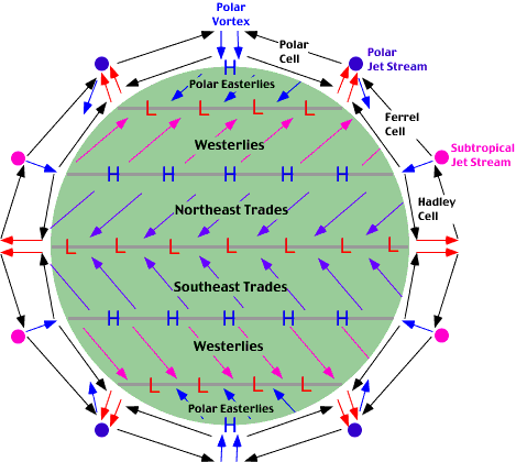
Therefore, in reality there are six convection cells in operation on Earth.....
Tri-Cellullar Model of Atmospheric Circulation
 - Intense insolation on the Equator starts the process of convection, leading to the formation of Hadley, Ferrel and Polar Cells
- The same pattern is seen in the southern hemisphere
- Wind pattern can be explained by the rule that air moves from excess to deficit as with each example the wind is blowing from areas of high pressure to low pressure, and then deflected by Coriolis
- Winds are named from the direction they are blowing from
- Trade Winds are so named due to their use in early trade, most infamously the Slave Trade - this provides a great synopitic link to development, colonialism and globalisation
Air Pressure Systems
- Falling air moves in a clockwise direction and spirals downwards = anticyclonic = high pressure = stronger of the two movements
ITCZ = Inter-Tropical Convergence Zone
- Its position changes with regards to seasons.....
---> British Summer Time = ITCZ north of the Equator so low pressure over India (=rain!)
---> British Winter Time = ITCZ south of the Equator and higher pressure over India
- Over land the ITCZ shifts furhter north or south of the Equator die to differences in the albedo between land and the oceans

I hope this is helpful - let me know if there is something I did not explain very well. On to Jet Streams and Rossby Waves next!!!


No comments:
Post a Comment